The past, present and future of the Mesopotamian marshes
Published: Sep, 2021 · Categories: Publications, Iraq
Overview
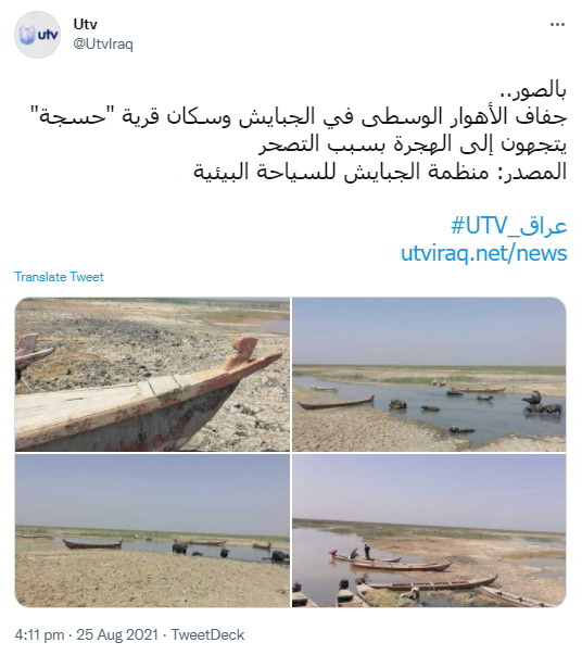
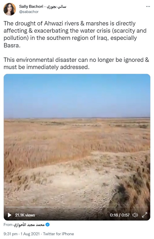
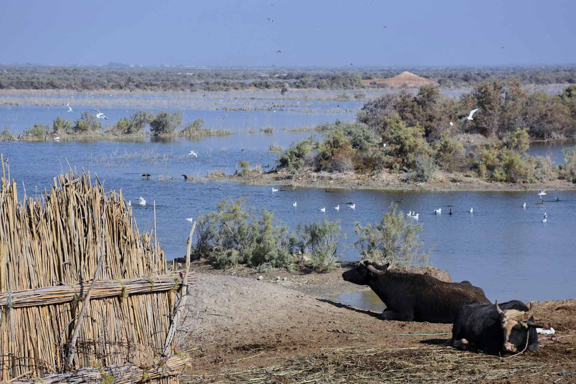
The Mesopotamian marshes carry huge environmental and cultural significance, yet have been ravaged by conflict, oil, pollution and despotism, and face an uncertain present and future. This report presents new visualisation-led perspectives on the marshes, based on CEOBS’ research that was part-funded by the Nahrein Network, and undertaken in association with the University of Thi-Qar, Iraq.
Although much has been written about the marshes, new insights can still be found. Our comparison here of 1967 declassified spy satellite imagery with that from the present day brings to light the scale of the cultural erasure of the Marsh Arabs. We also provide new perspectives on the current threats to the marshes – from pollution, fire, saltwater intrusion and the oil industry – although much remains unknown. This is particularly true for the future climate of the Mesopotamian marshes, which may provide crucial ecosystem services for the region, amidst the alarming temperature projections we show. Finally, an exploration of the potential of eco-tourism shows the kind of locally driven nature-positive steps that could help the marshlands recover and flourish.
Key findings
-
New insights into the scale of marshland drainage and cultural erasure from 1967 to the present day, and the relative roles that oil exploration, agricultural expansion, conflict and state-sanctioned ecocide have played.
-
The marshes face significant and existential challenges from climate change and poor environmental governance, which leads to pollution from the oil sector and sewage, saltwater intrusion and fires.
-
Coupled climate-hydrological modelling is required to build the evidence base to inform government policy on how to protect and restore the marshes, to ensure that communities benefit from the ecosystem services they provide.
-
Ecotourism has the potential to help protect and monitor the marshes, provide sustainable livelihoods, and educate a global audience.
Contents
1. Introduction
The Mesopotamian marshes are found in southern Iraq on the floodplains of the Euphrates and Tigris rivers, bound by the cities of Basra, Nasiriyah and Amarah. They are subdivided into three distinct marshes – Hammar, Central, and Hawizeh. The unique wetland landscape is home to the Marsh Arabs, descended from the Ur, Sumer and Babylon civilisations, who have developed a unique culture tightly coupled to the landscape – harvesting reeds and rice, fishing and herding water buffalo.
The marshes provide a habitat for important endemic and endangered wildlife, and water levels are greatest in early Spring time owing to a pulse of freshwater from snowmelt upstream in the Turkish and Syrian mountains. It is for this reason that the majority of imagery presented here are from the first quarter of each year. More detail and graphics on the marshes geographic setting, biodiversity and role in antiquity are presented in the Appendix.
2. New perspectives on the past
The first earth observation imagery of the marshes was taken in the 1960s, through the American CORONA reconnaissance satellite programme. This data was only declassified in 2002. The first cloud free overpass of the marshes was in September 1963 and is presented in Figure 1, showing the marshes at close to their maximum extent. When compared to the lowest recorded extent in 2003, the loss of marshland is phenomenal.
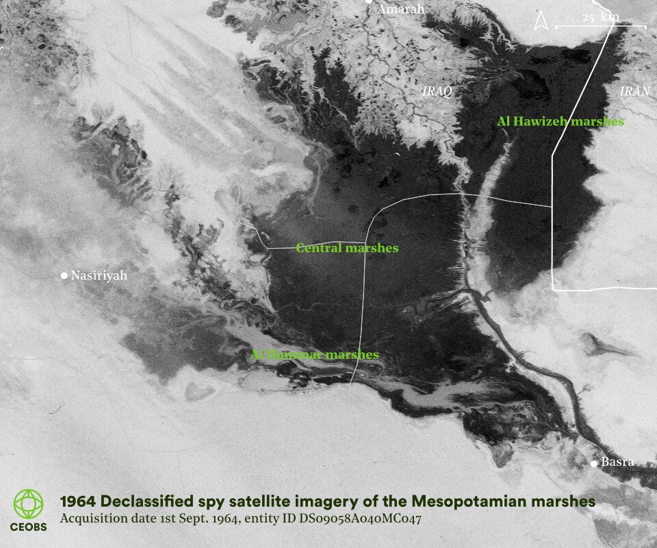
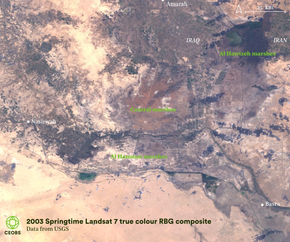
Figure 1. Comparison of Mesopotamian wetland extent before large-scale interventions in 1963, and at its minimum in 2003.
Although the 1964 image doesn’t have a fine enough resolution to give a detailed view of life in the marshes, a reel of high-resolution images from January 1967 does. Unfortunately, these insights have remained unseen for the marshland area as a whole, owing to the difficulty of working with the data. That is, until now – CEOBS has manually georeferenced and mosaiced together the nearly 30 film frames encompassing the area.
This was a painstaking and challenging task – and remains imperfect. The scale of the landscape change has made more automated approaches unworkable. Yet incredibly, in some instances, the level of detail is even better than the current base imagery in Google Maps. What this high-resolution satellite imagery reveals is remarkable – the near total collapse of the Marsh Arabs culture. The stories of the eight locations highlighted in Figure 2 are told below, as seen from space.
To augment these top-down views, we point readers in the direction of the photography of Tor Eigeland, who also visited the marshes in 1967 and captured a Marsh Arab culture he described as feeling timeless. His photos are collated in the book ‘When All the Lands Were Sea’, with many viewable in an accompanying National Geographic article. This glimpse into life in the marshes is captivating, showing canoes gliding along the waterways, ancient weaving techniques, gatherings around an open fire in a mudhif reed house and swimming water buffalos.
The georeferenced 1967 satellite imagery is likely of great use for future research and educational work – it is available to download on request.1
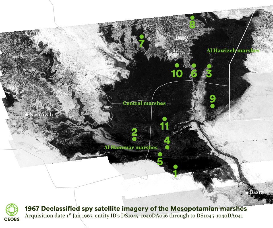
Figure 2. Extent of the Mesopotamian marshes in 1967. Numbers refer to the examples locations investigated further in this article.
2.1 Oil
Across the marshes there are many large oil deposits, the prospecting and refining of which have led to marshland clearance and pollution. Figure 3 illustrates the strong relationship between the marshland area cleared and the oil fields.
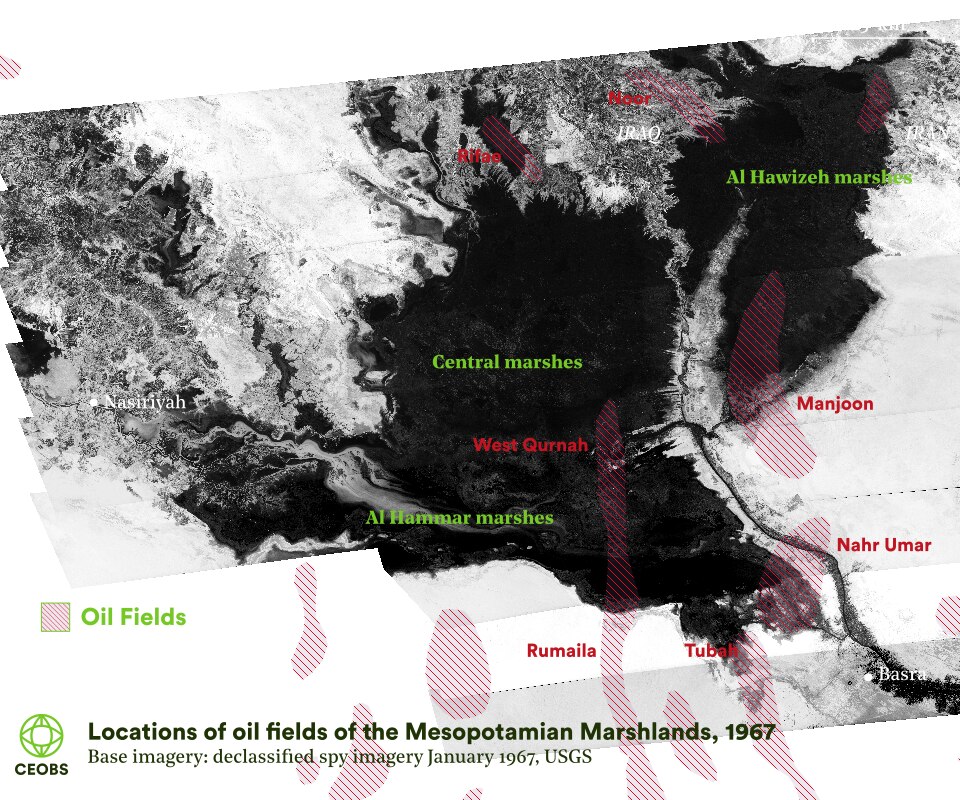
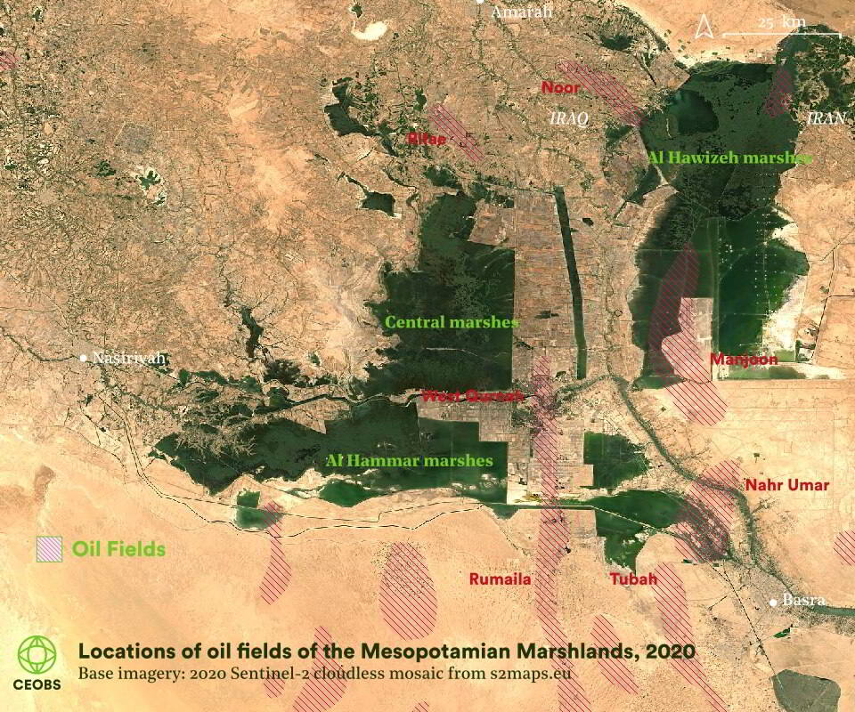
Figure 3. Imagery of the Mesopotamian marshlands in 1967 and 2020, with the locations of oil fields overlain. Oil data source: Library of Congress Geography and Map Division Washington, digital ID: http://hdl.loc.gov/loc.gmd/g7611h.ct002114.
For example, in the southern Hammar marshes, development of the north Rumaila field resulted in a loss of around 800 km2 of marshland – clear in Figure 4. Although discovered in the early 1950s, full-scale production did not commence until the 1970s, with production peaking in 1979. During the 1980s there was a 150 km2 expansion of the Rumaila fields, into the western part of the Central marshes.
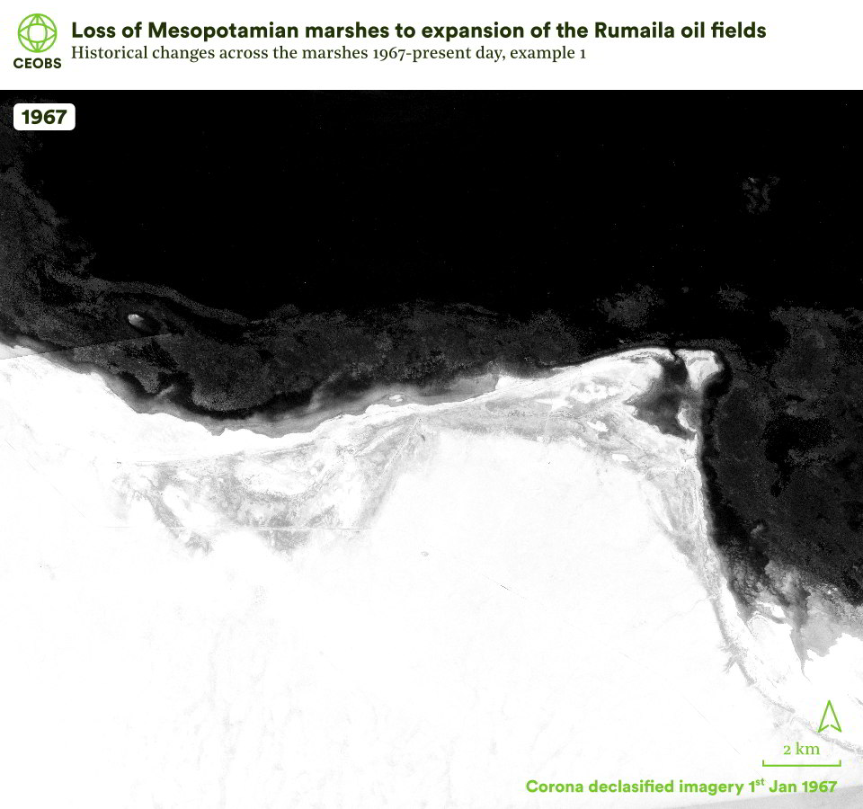
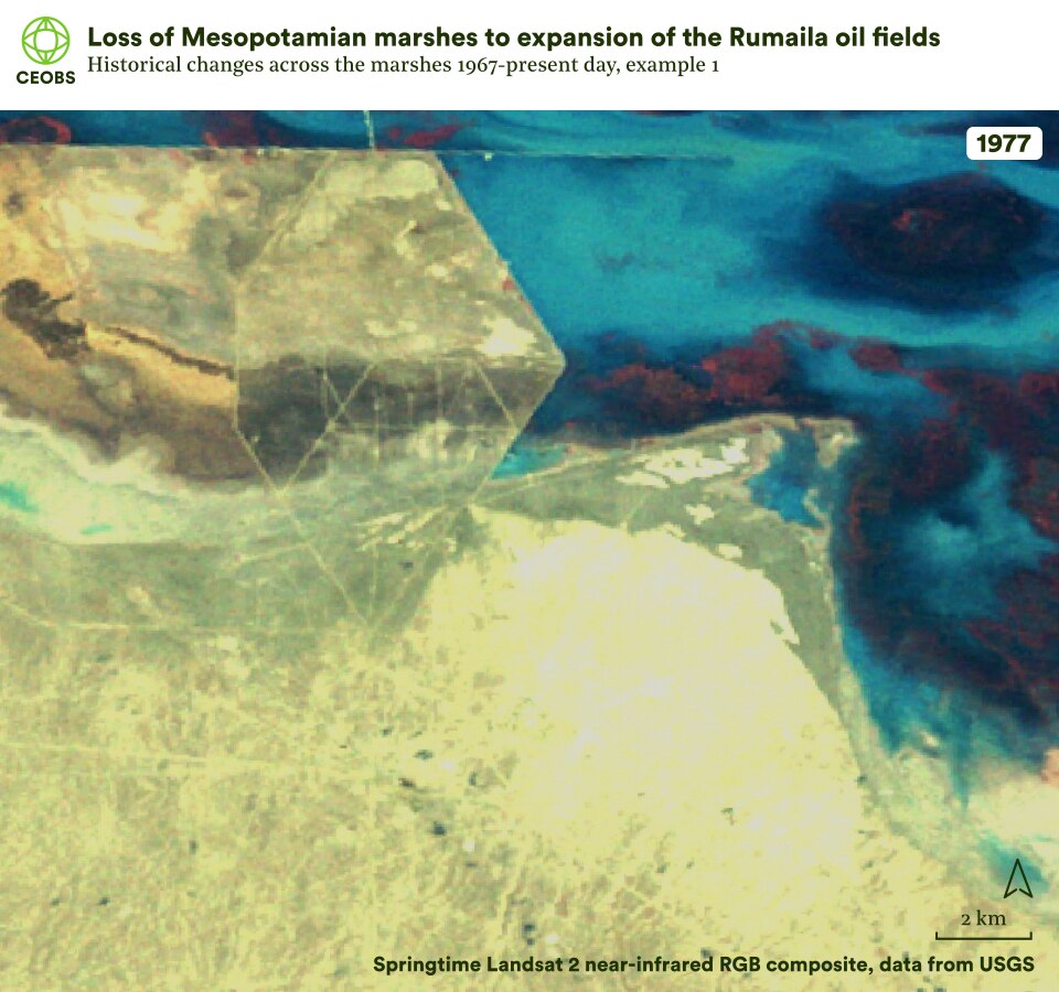

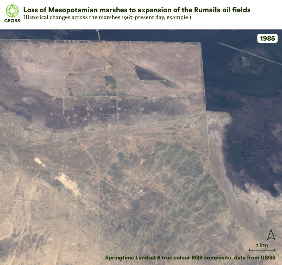

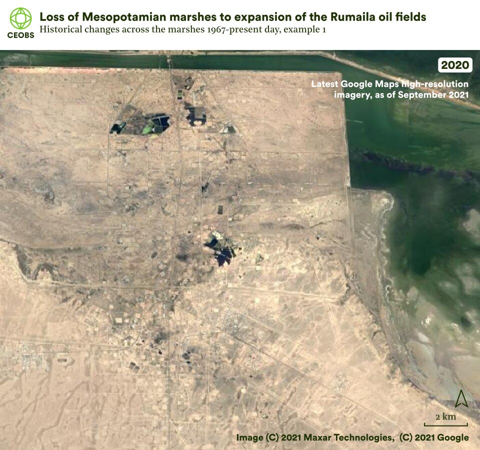
Figure 4. Example location 1, the Rumaila oil fields, comparing satellite imagery of Mesopotamian marshes in 1967 with that in the subsequent years following land cover change. Use the slider to compare the imagery, and use the left/right arrows to change the year of comparison.
Another location of interest is the Noor oil field in the north of the Hawizeh marshes. Here, we can see how a settlement of approximately 150 huts was cleared in the mid-1980s to allow oil prospecting. Further to the south, the Majnoon oil field grew in the 1980s, despite sitting on the front-line of the Iran-Iraq war.
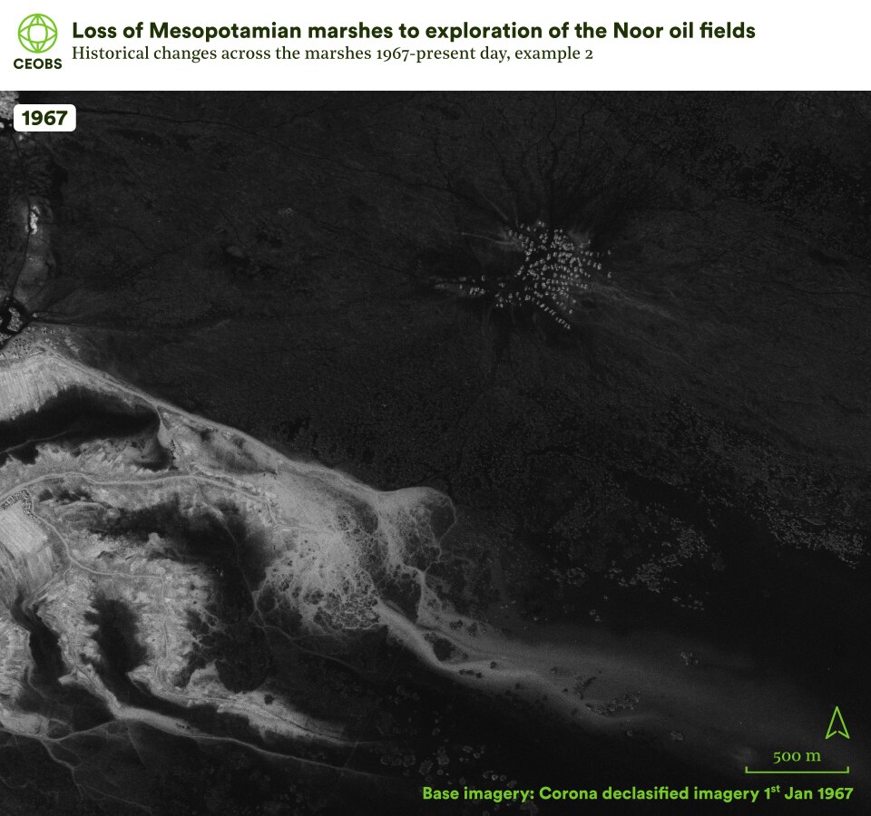
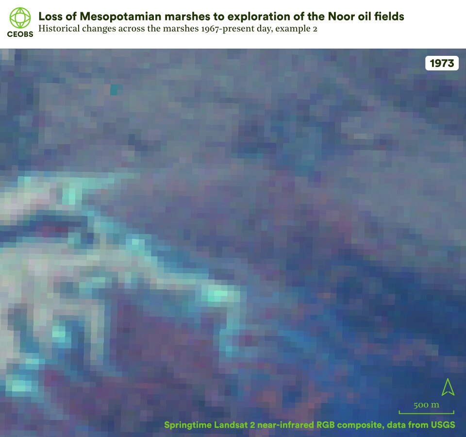

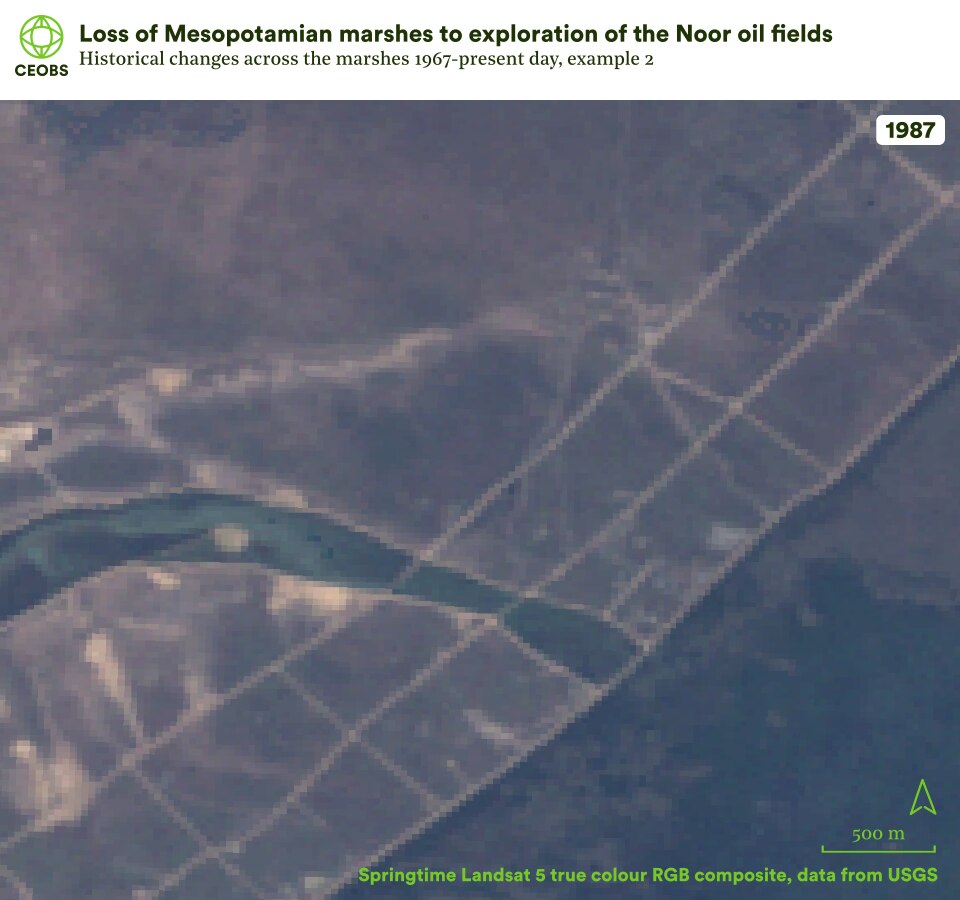

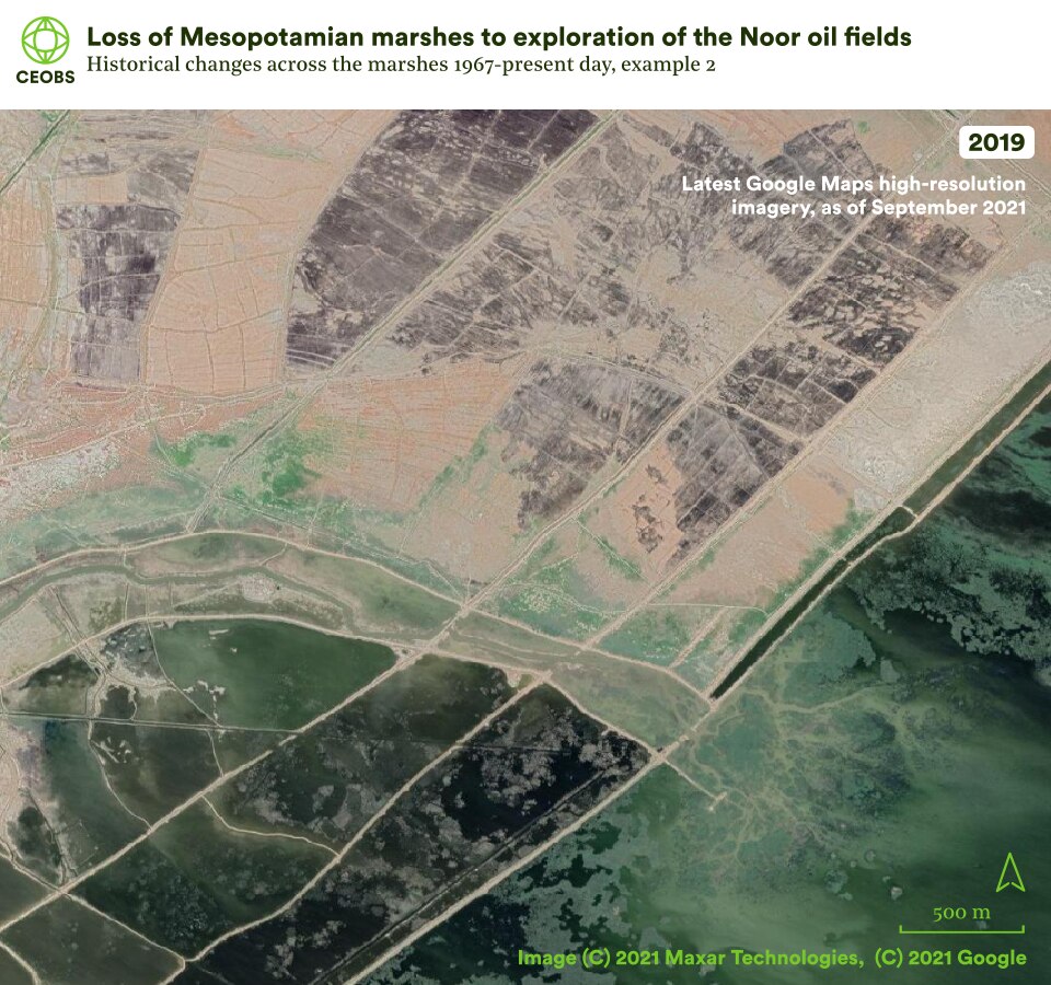
Figure 5 . Example location 2, the Noor oil fields, comparing satellite imagery of Mesopotamian marshes in 1967 with that in the subsequent years following land cover change. Use the slider to compare the imagery, and use the left/right arrows to change the year of comparison.
2.2 War
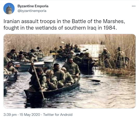
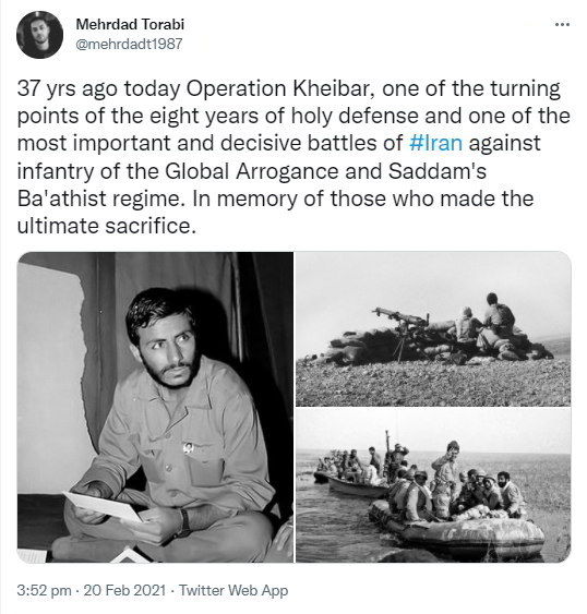
The marshes sustained significant ecosystem damage during the Iran-Iraq war in the 1980s. Large battles took place in Al Hawizeh, where there was burning, bombing, and the widespread use of chemical weapons. War correspondent Robert Fisk described some of the destruction:
“Al-Fakhry [Iraqi commander] brought huge tanker trucks down and pumped fuel into the marshland and then fired shells into the water and started the biggest fire I’ve seen in my life. He burned and killed everything, the whole environment.”
Large areas of reed-beds were removed in the hunt for deserters, damaged by armoured boats, or simply burned. A Washington Post article grimly reports how the water in the wetlands itself was used as weapon, and the war dead were used to re-landscape the marshes. Amongst the dead were innocent Marsh Arabs. Photographs from the marshes during the 1980s illustrate the militarisation and weaponisation of the environment. Figure 6 illustrates how the front lines of the war were directly on the marshes, and involved large-scale engineering works that are still visible on the landscape today.
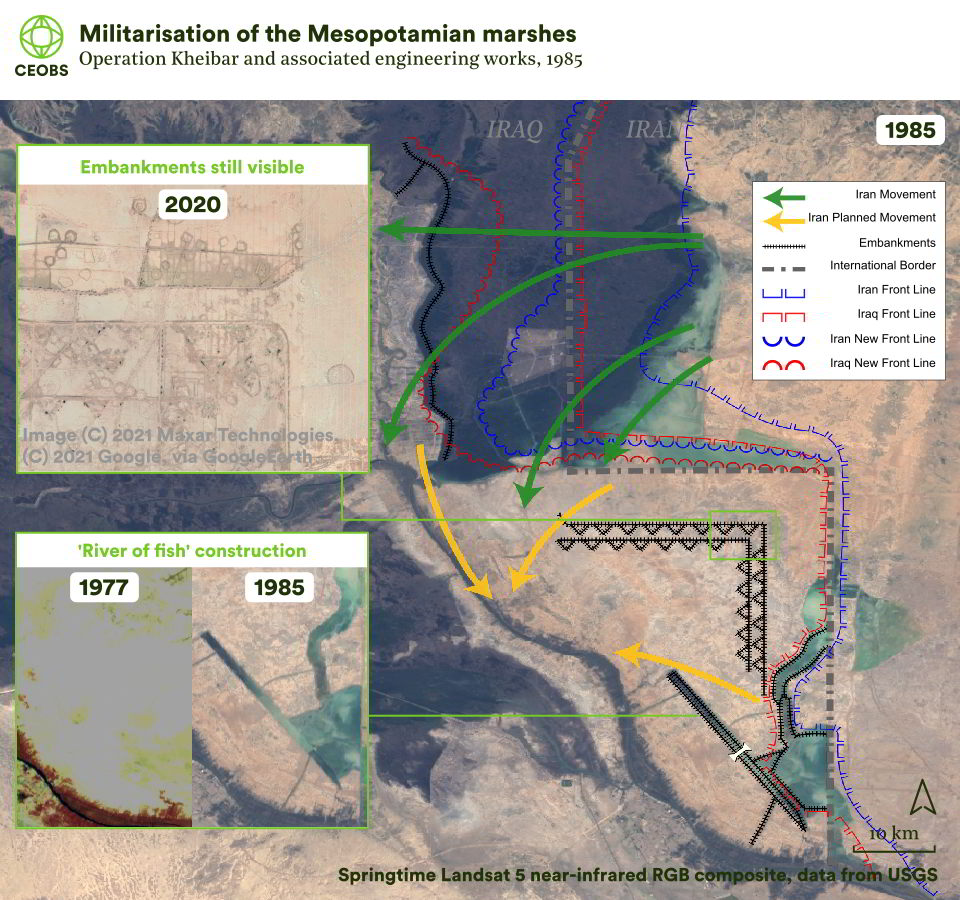
Figure 6. Militarisation of the Mesopotamian marshes as visible from space in the 1980s and present day. Operation Kheibar frontlines, movements and embankments adapted from a map produced by Wikimedia users AnonMoos and Gire_3pich2005, based on Colonel Jafari, Mojtaba (2006) “Chapter 4: Fourth year; Political forces for imposing peace” in Atlas of Unforgettable Battles, Tehran: Operations Holy Defence Research Center, p. 96 ISBN: 964-06-5515-5. Adapted under the terms of the Creative Commons Attribution 3.0 Unported license.
One of the key events that eventually led to the end of the war were the ‘Tawakal ala Allah’ operations, which led to Iraq retaking the Manjoon oil fields and pushing Iran back. The conventional understanding is that this was decisively facilitated by a drying of the marshes – this is borne out by the satellite imagery, which shows a vast area of former marshland now dry and Manjoon ‘island’ accessible to tanks in 1988. Where water was an issue, thousands of tonnes of gravel were poured into the marsh.
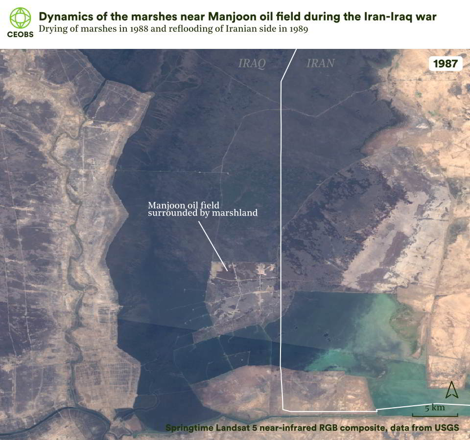
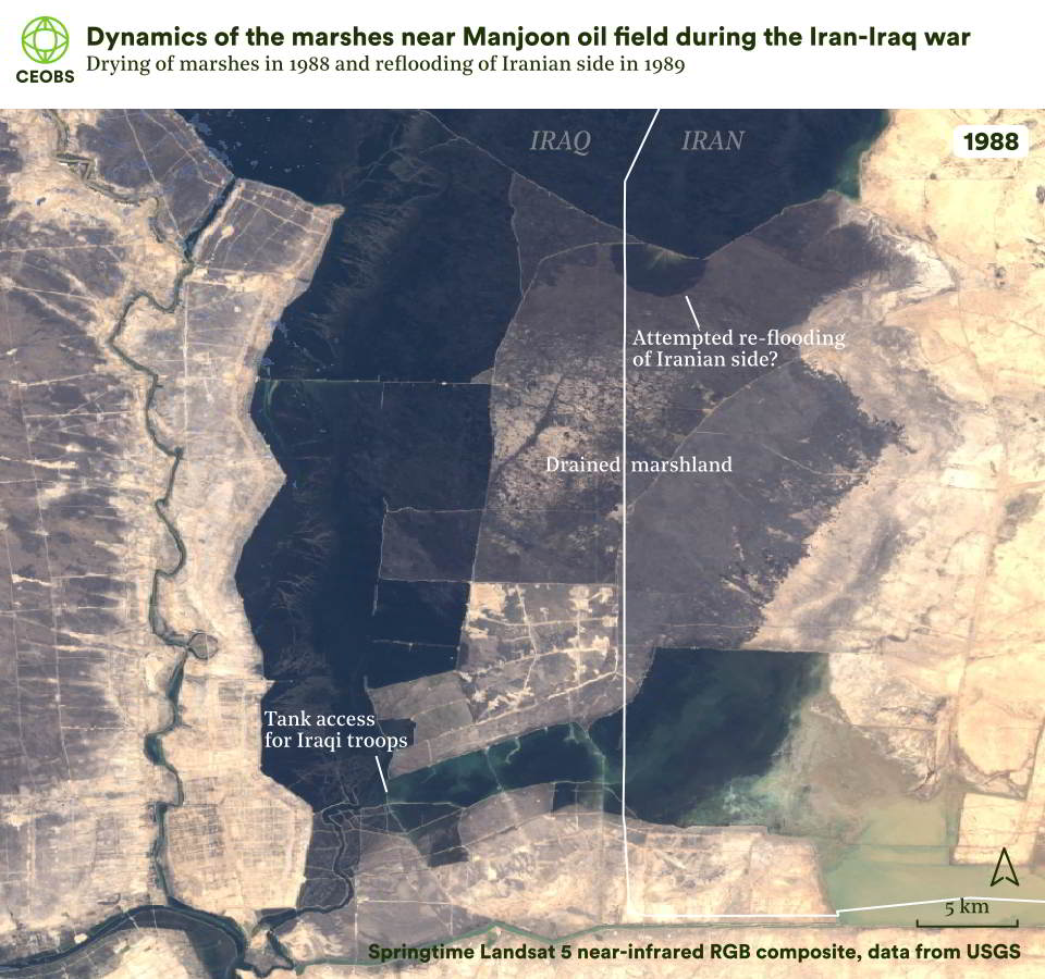
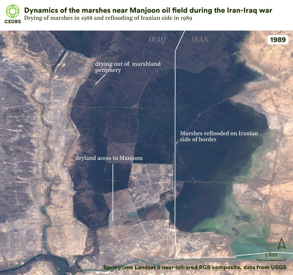
Figure 7. Satellite imagery showing the dynamics of the marshland surrounding Manjoon oil field, the locus of the ‘Tawakal ala Allah’ military operation.
But what caused this drying out of the marshes? There are few authoritative sources, but according to Wikipedia it was a mix of drought and engineering. With the benefit of longer-term meteorological datasets, our analysis shows that for the period leading up to the battles in Spring 1988, the Tigris and Euphrates watershed had above average rainfall. What’s more, the satellite imagery indicates that the extent of the Central and Hammar marshes were greater in 1988. Together, this suggests a more significant role for engineering – with the success perhaps providing the blueprint for the more drastic widespread drainage in the 1990s.
In the spring following the ‘Tawakal ala Allah’ operation, engineering works had opened a 10 km wide land strip to Manjoon, likely assisted by the now rainfall, and reflooded the eastern area to create a boundary with Iran. Altogether, hydrology and manipulation of the marshes had become key to the war, especially drainage where it allowed access to oil.
Deportations of Marsh Arabs had begun in 1983, under the euphemistic title “Operation Peace”. The population was placed under economic siege, with registration required for boats, the prohibition of fishing and hunting, the monitoring from above by helicopters, and revocation of food rations – compounded by the loss of nearly a quarter of the buffalo herd to disease and fighting. Figure 8 illustrates the razing of a large Marsh Arab settlement between 1980 and 1985, and then the militarisation of the area between 1985 and 1989. Following the end of the war, thousands of homes and canoes were destroyed, while some locations had suffered this fate due to the fighting itself.
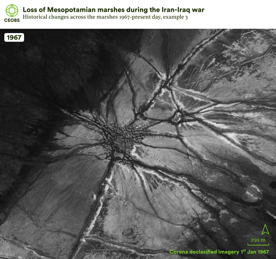
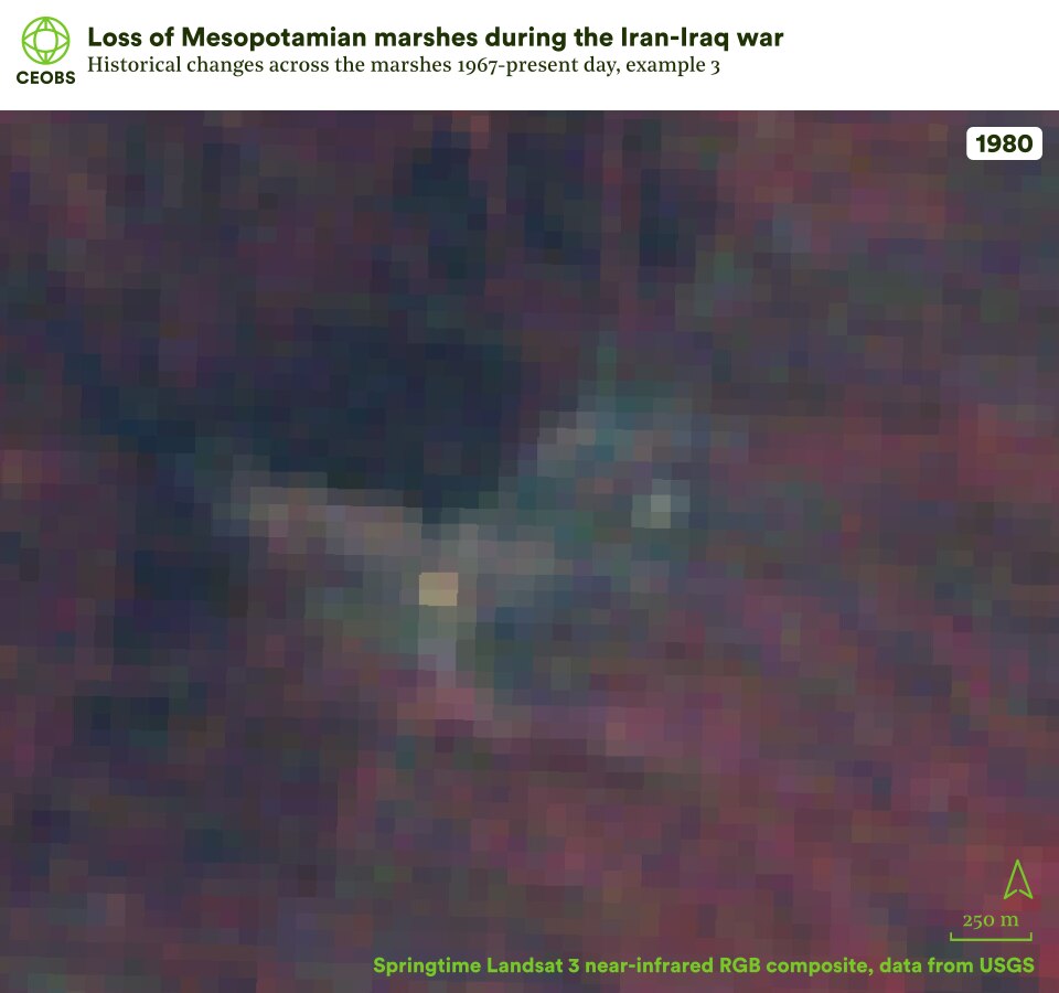

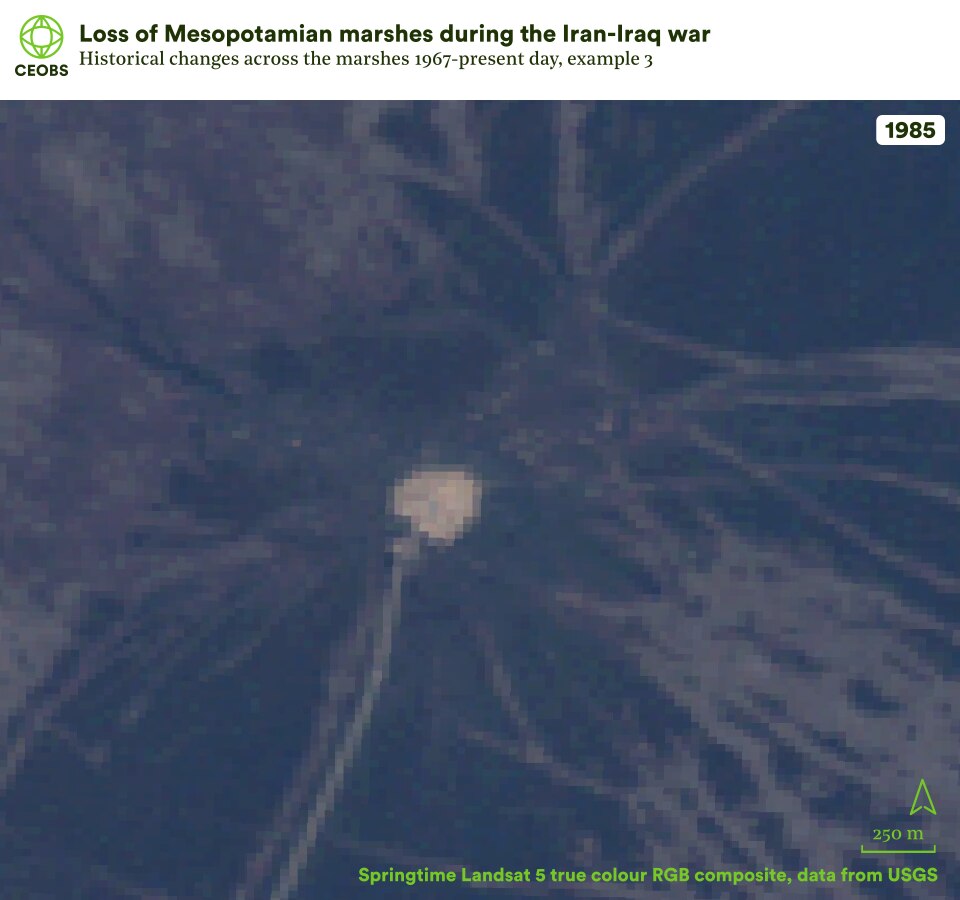

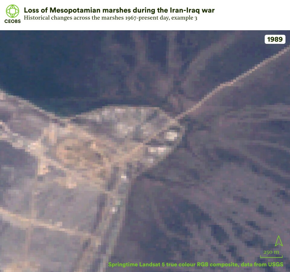

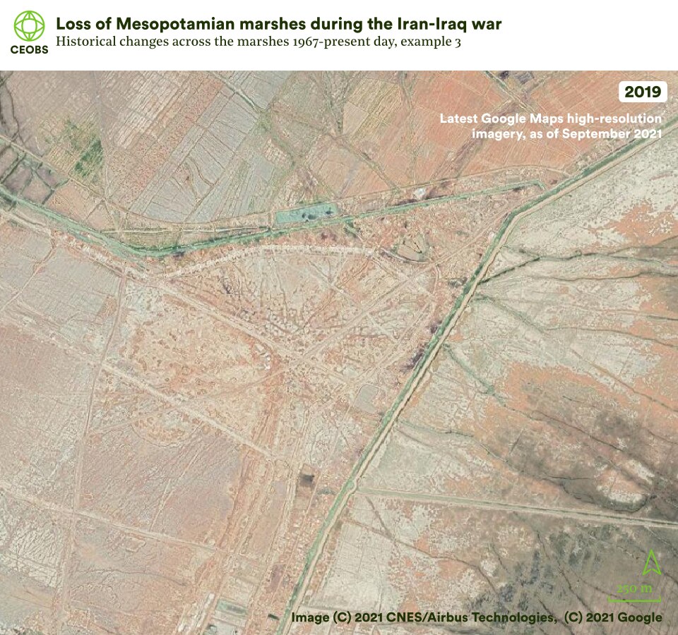
Figure 8. Example location 3, a front of the Iran-Iraq war, comparing satellite imagery of Mesopotamian marshes in 1967 with that in the subsequent years following land cover change. Use the slider to compare the imagery, and use the left/right arrows to change the year of comparison.
Amid the political motivations for the conflict, there was also the prize of oil reserves. However, the war had a long-lasting effect on the industry. From a peak production of 3.5 mb/d (million barrels per day) at the end of the 1970s, the Iran-Iraq war reduced production down to 1 mb/d, owing to regional geopolitics and the significant damage sustained to export and storage infrastructure.
2.3 Agriculture
The 1970s and 1980s saw increasing pressures on the marshlands from hydrological projects upstream. In Turkey, major dams were constructed, reducing the flow of the Euphrates, whilst in Iraq work on the Main Outflow Drain through the country was progressing and many local irrigation channels were constructed to facilitate agricultural expansion.
Coincident with the wartime damage were the ongoing consequences of development in Iraq and further afield. In particular, large areas of the marshes were being rapidly converted into agricultural fields – whilst agriculture upstream took an increasing share of the diminishing Tigris and Euphrates flow. Indeed, although the marshes had historically been considered freshwater systems, from the 1980s salinity increased, particularly in the southern Al Hammar marshes. The primary cause was attributed to the continuous flushing of salts from cropland into the Al Basrah Canal, agricultural wastewater that was then directed into Al Hammar.
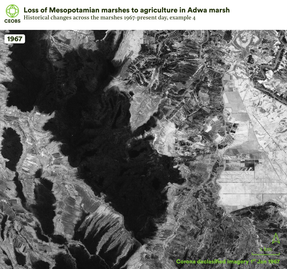
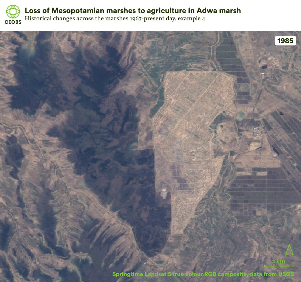

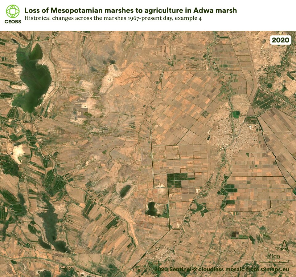
Figure 9. Example location 4, agricultural expansion in Adwa marsh, comparing satellite imagery of Mesopotamian marshes in 1967 with that in the subsequent years following land cover change. Use the slider to compare the imagery, and use the left/right arrows to change the year of comparison.
2.4. Cultural erasure
In 1991, amidst the aftermath of the Gulf War, the marshes and the Marsh Arabs faced their most serious threat to date. Saddam Hussein began a massive drainage programme, redirecting the Tigris and the Euphrates into a ‘Third River’ that bypassed the marshes. This involved a myriad of gates, locks, sluices and levees to re-route marshland water. The project was a punishment act to assert his power, following an uprising from the Marsh Arabs and other Shi’a groups.
During the 1990s there were widespread and systemic attacks on Marsh Arabs, including torture, murder, persecution and forced displacement. In 2003 Human Rights Watch summarised these as constituting crimes against humanity, and estimated that of the 250,00 Marsh Arabs in 1991, only 40,000 remained in their ancestral homeland. The drainage projects were sold to the public as agricultural improvement, but given the associated artillery attacks and mass arrests, it was clear the aim was to quash dissent by erasing a culture and a landscape.
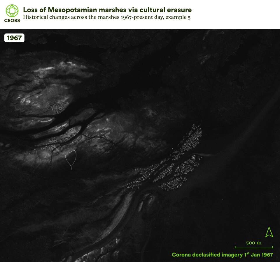
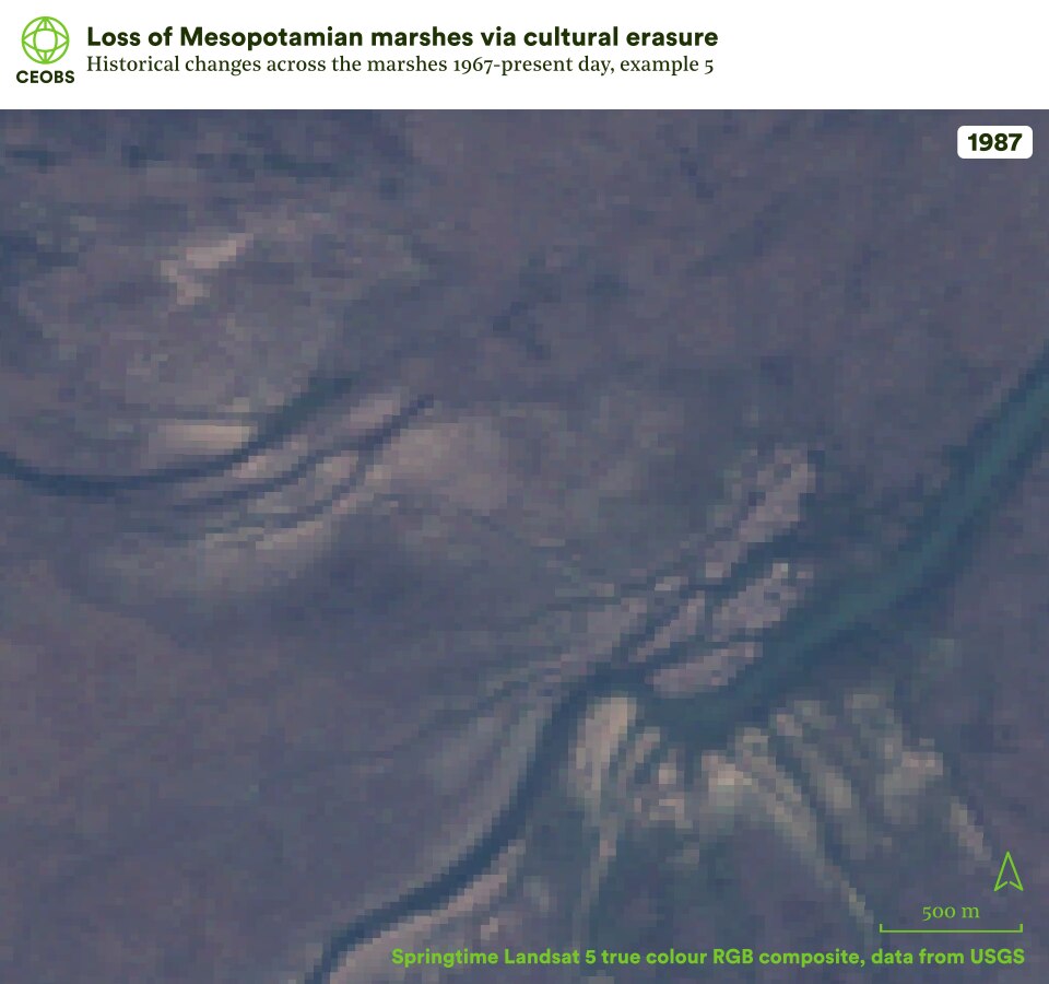

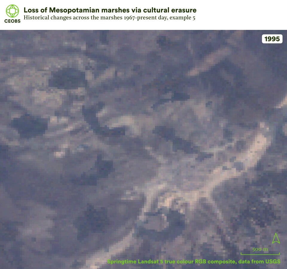

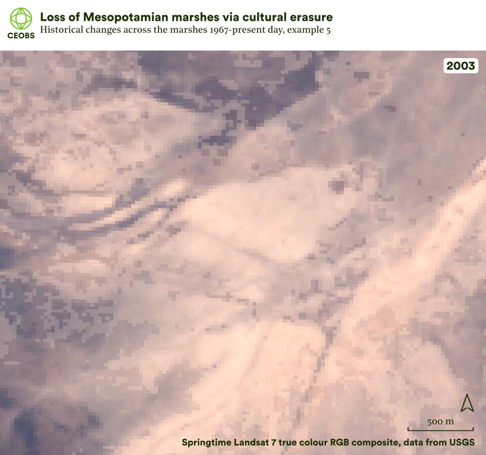

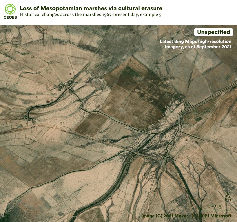
Figure 10. Example location 5, cultural erasure (i), comparing satellite imagery of Mesopotamian marshes in 1967 with that in the subsequent years following land cover change. Use the slider to compare the imagery, and use the left/right arrows to change the year of comparison.
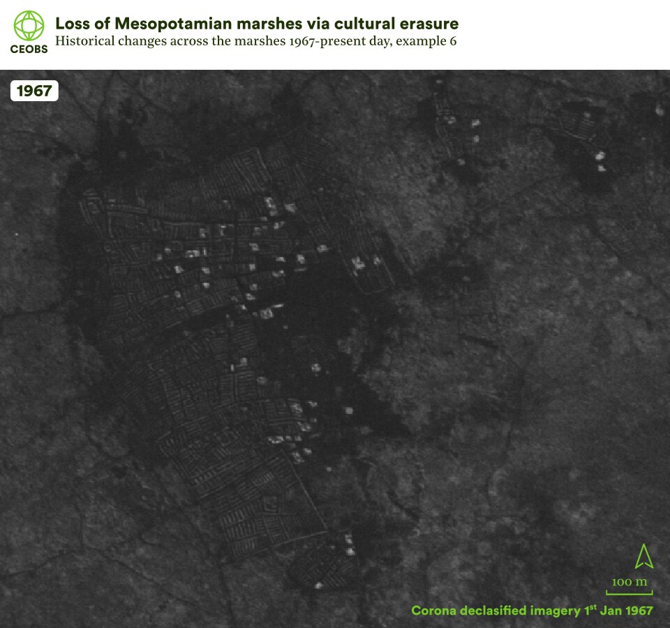
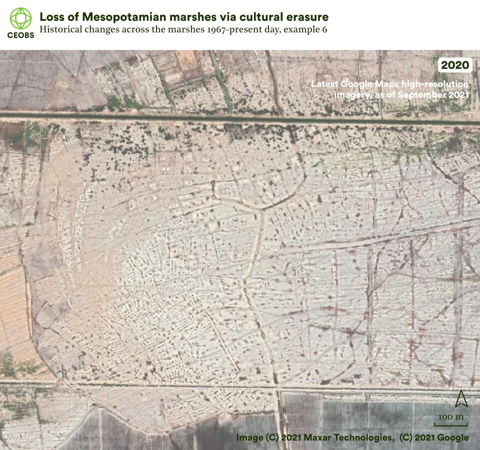

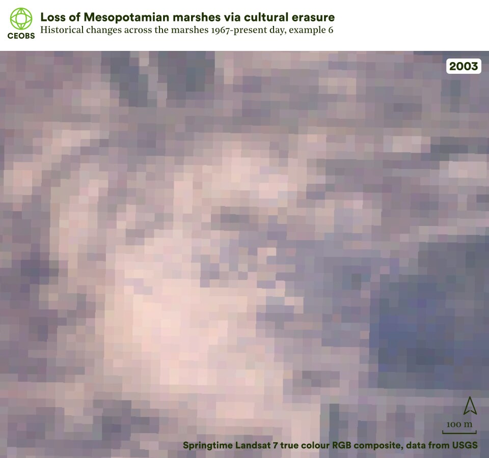
Figure 11. Example location 6, cultural erasure (ii), comparing satellite imagery of Mesopotamian marshes in 1967 with that in the subsequent years following land cover change. Use the slider to compare the imagery, and use the left/right arrows to change the year of comparison.
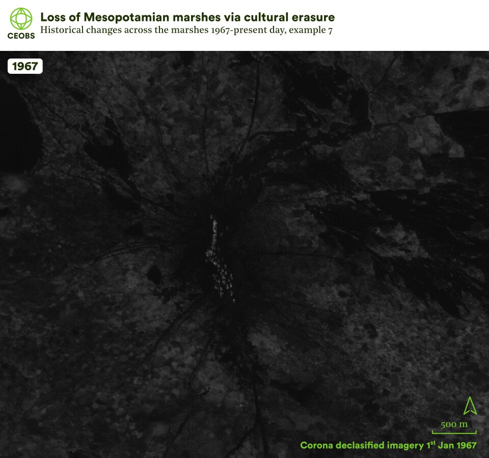
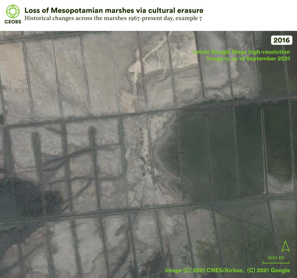

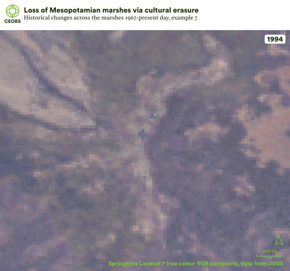

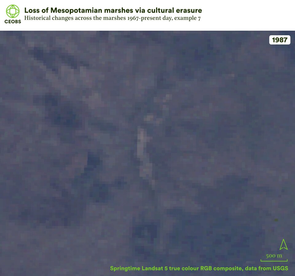
Figure 12. Example location 7, cultural erasure (iii), comparing satellite imagery of Mesopotamian marshes in 1967 with that in the subsequent years following land cover change. Use the slider to compare the imagery, and use the left/right arrows to change the year of comparison.
The location of the key engineered waterways are illustrated by the pink lines in Figure 13, many of which were ostentatiously named to empower the regime. This drainage plan was not a new one – it leaned on the Haigh report, written in 1951 by British engineers during the period of the British Mandate. They believed marsh water was wasted and would be better used as irrigation water to help avoid soil salination. It was on the back of this report that Saddam Hussain could undertake and justify one of the worst man-made ecological disasters in history.
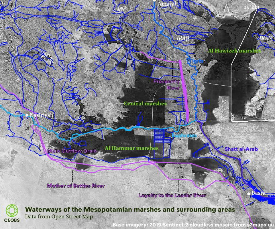
Figure 13. Waterways of the Mesopotamian marshes. The largest canal is the Main Outfall Drain or Third River or Saddam River, which was completed in 1992 after nine months of round the clock shifts. This originates near Baghdad, diverting both Tigris and Euphrates water into a channel that travels beneath the Euphrates, around the southern extent of the marshes and into the Gulf. The most striking waterway is the 2 km wide Prosperity River or Glory River, which flows north to south, it was built in 1993 to prevent any overflow into the marshes from the Tigris. The Mother of Battles (1994) and Loyalty to the Leader (1997) rivers both divert Euphrates water to the south of the marshes. Not included on the map, as it lies to the north of the marshes, is the Crown of Battles River, which diverts the Tigris away from the Al Hawizeh marshes. Further to the new waterways were 70 km of embankments built along the Euphrates to separate the Central and Al Hammar marshes.
2.5 The 2003 reflooding
With the fall of Saddam Hussain and his government in 2003, a unique opportunity opened up to restore the marshlands. This happened not with a carefully coordinated programme, but spontaneously with the triumphant destruction of dams, dikes and levees by the marsh communities, allowing the water to flow from the Tigris and Euphrates back towards the marshes.
By 2006, it was estimated that approximately 39% of the former extent of the marshes had been reflooded, with native species of flora and fora returning – but the full ecological restoration of the marshes remained unknown. The displaced Marsh Arabs started to return back to the marshes, hoping to resume their buffalo herding and fishing. To our knowledge numbers on the scale of this return are not available.
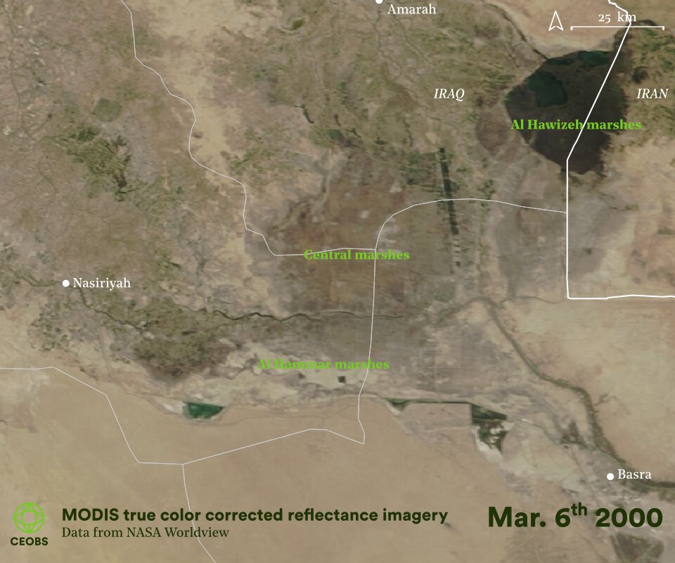
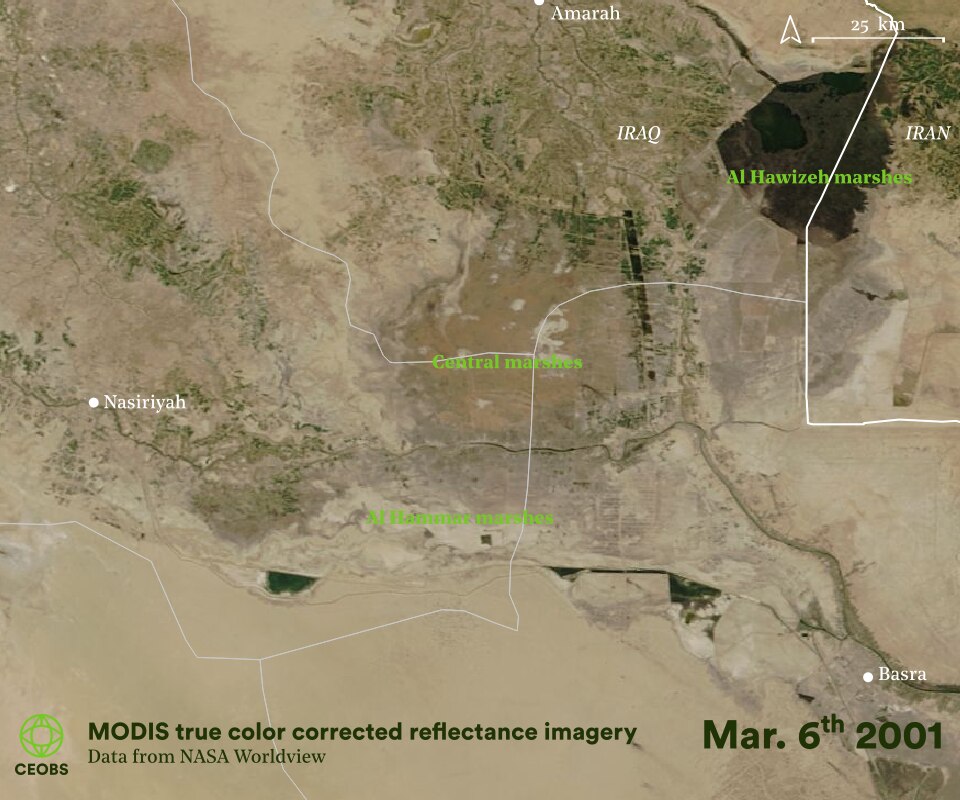
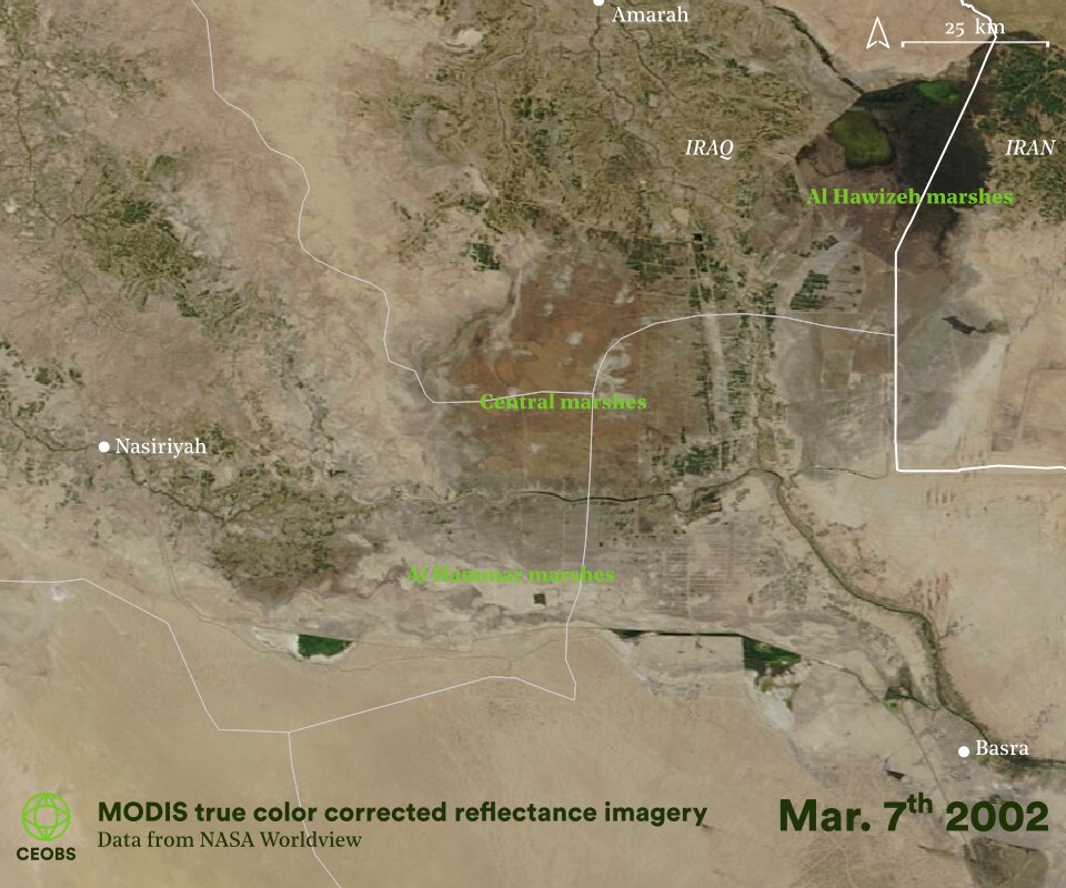
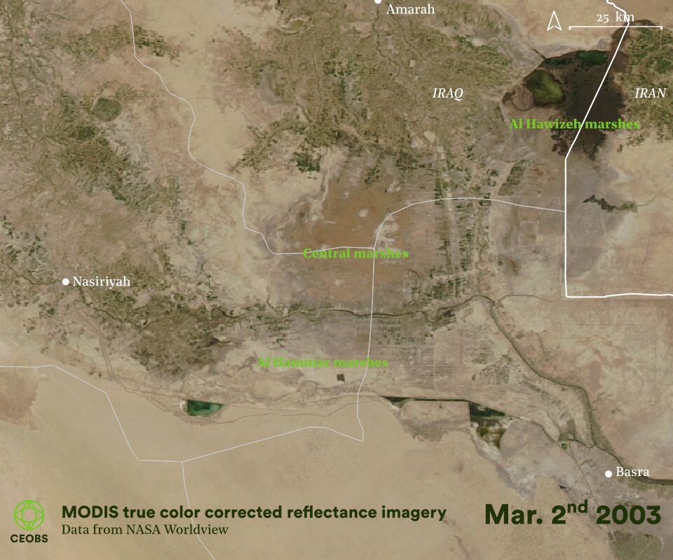
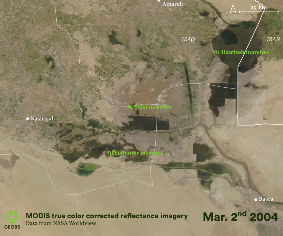
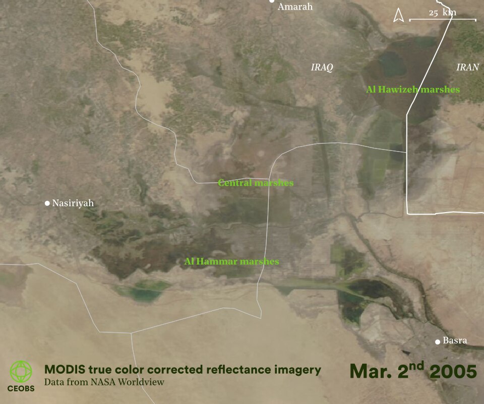
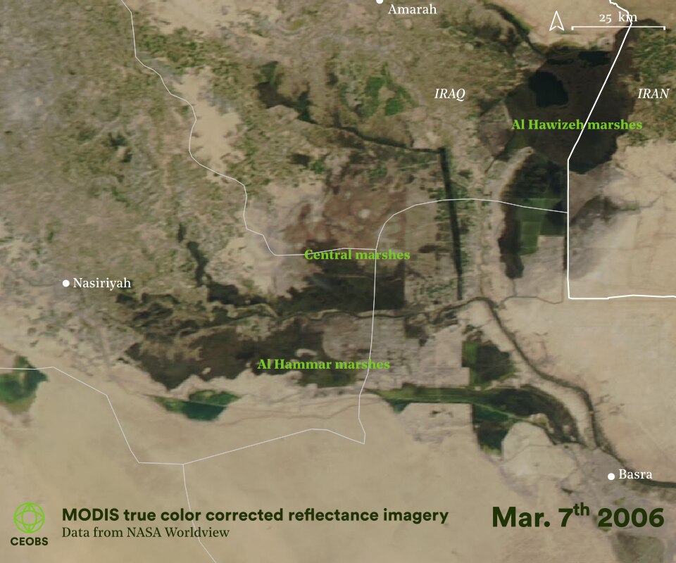
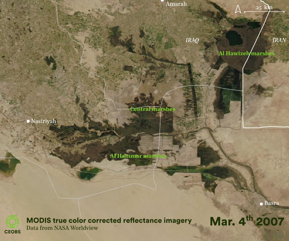
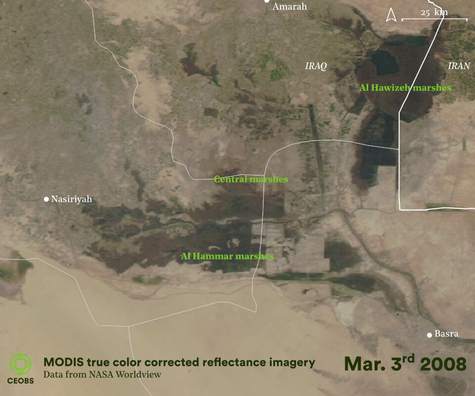
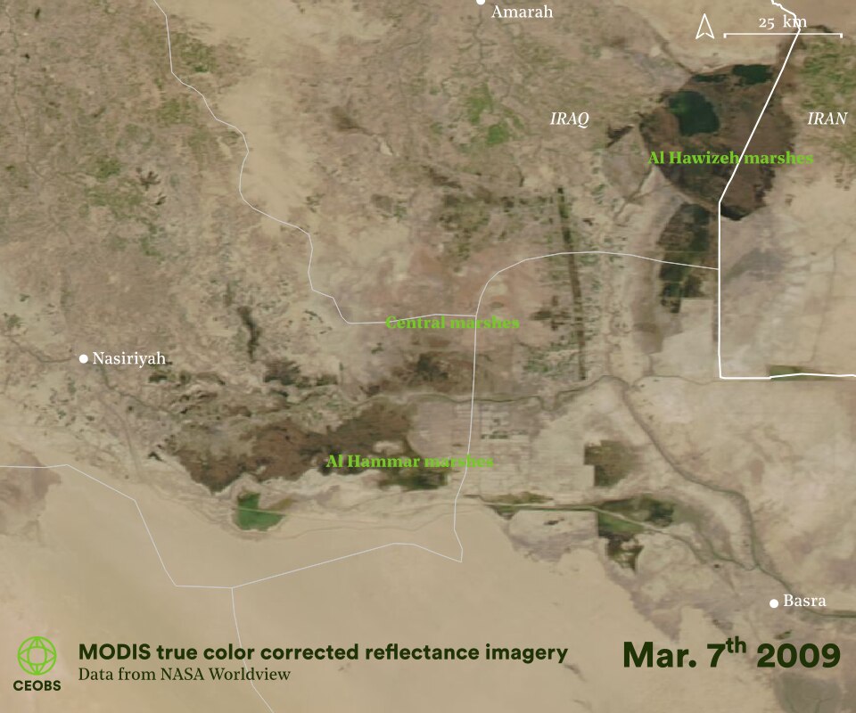
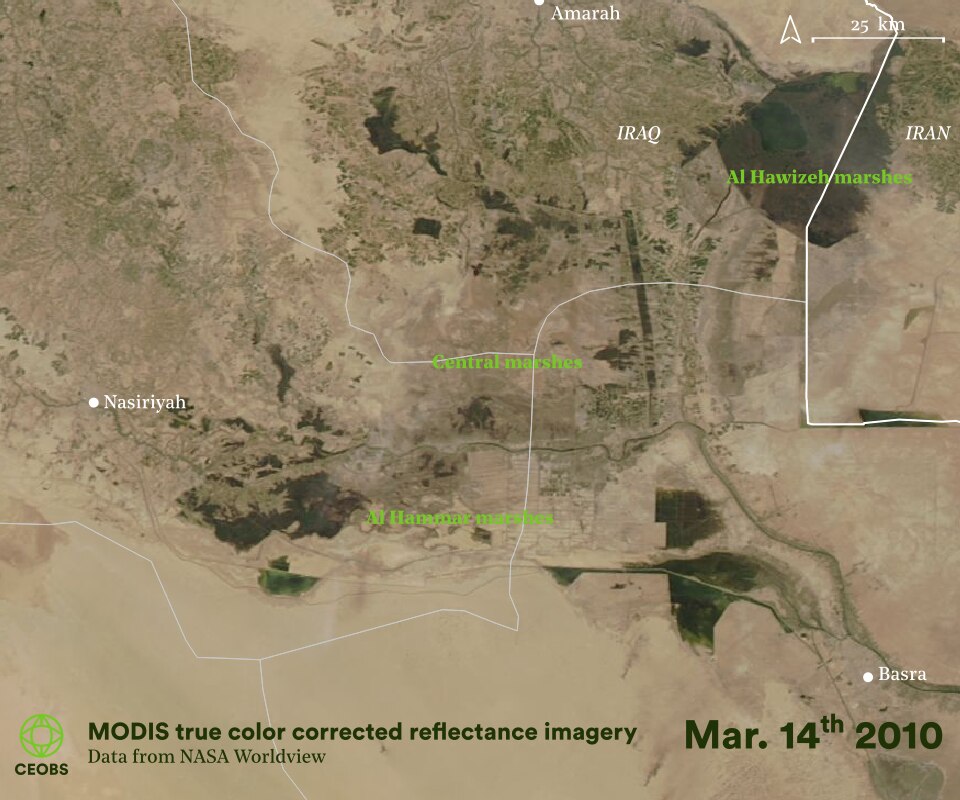
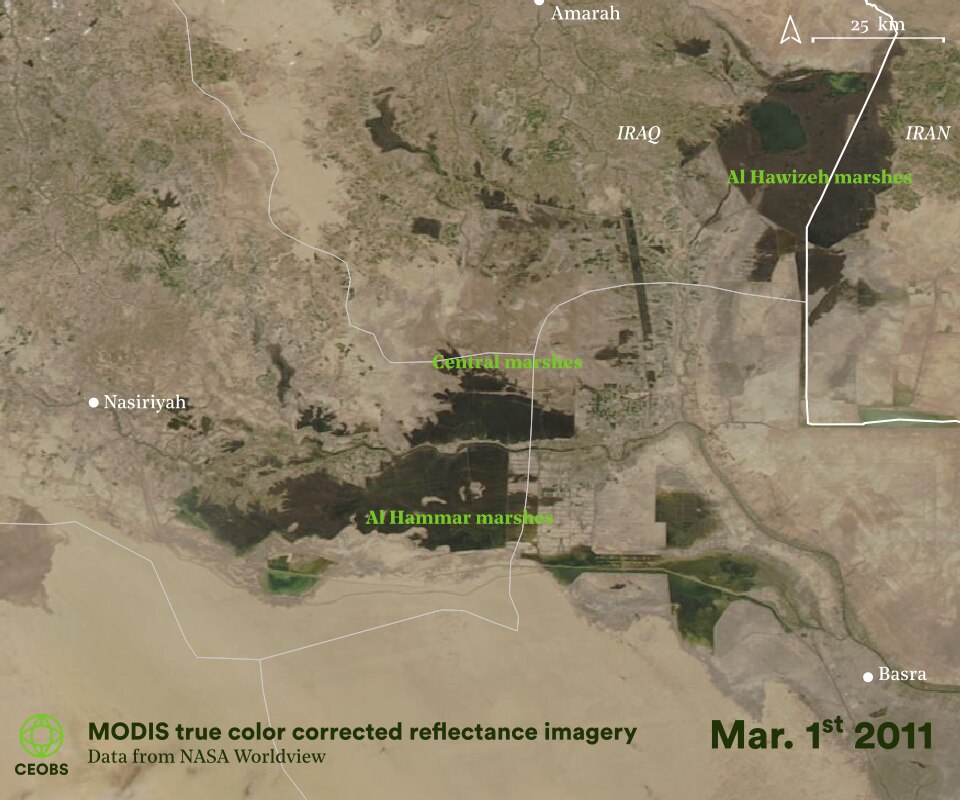
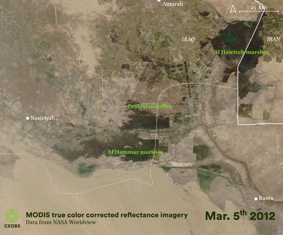
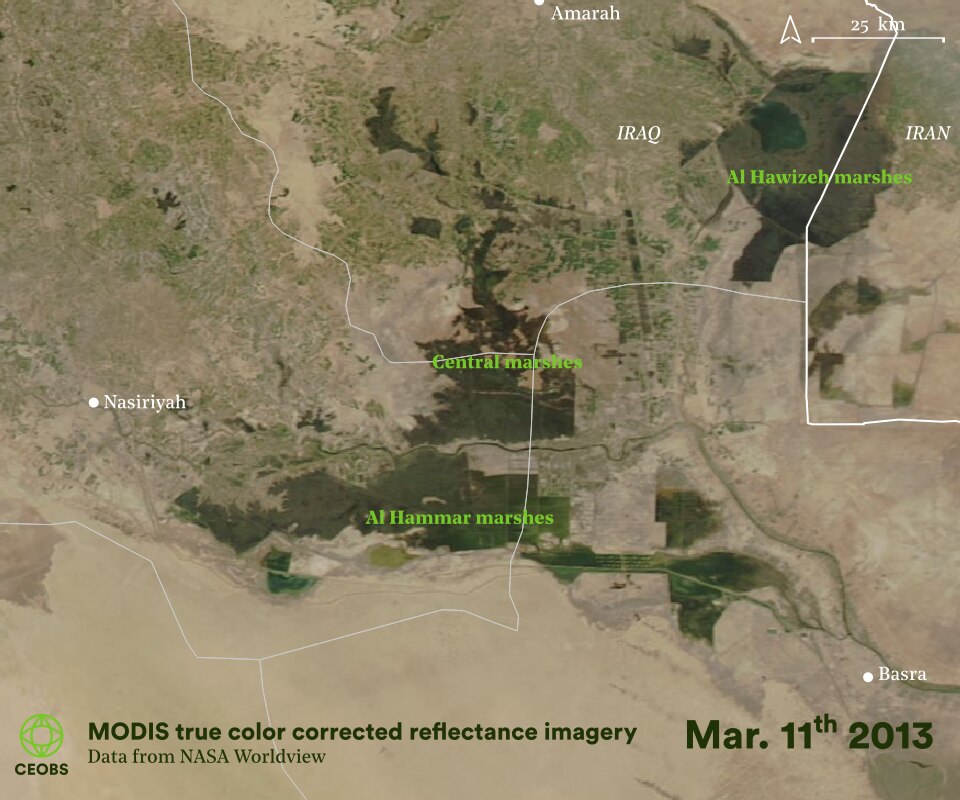
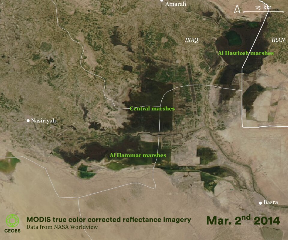
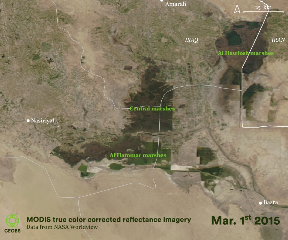
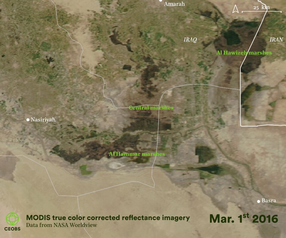
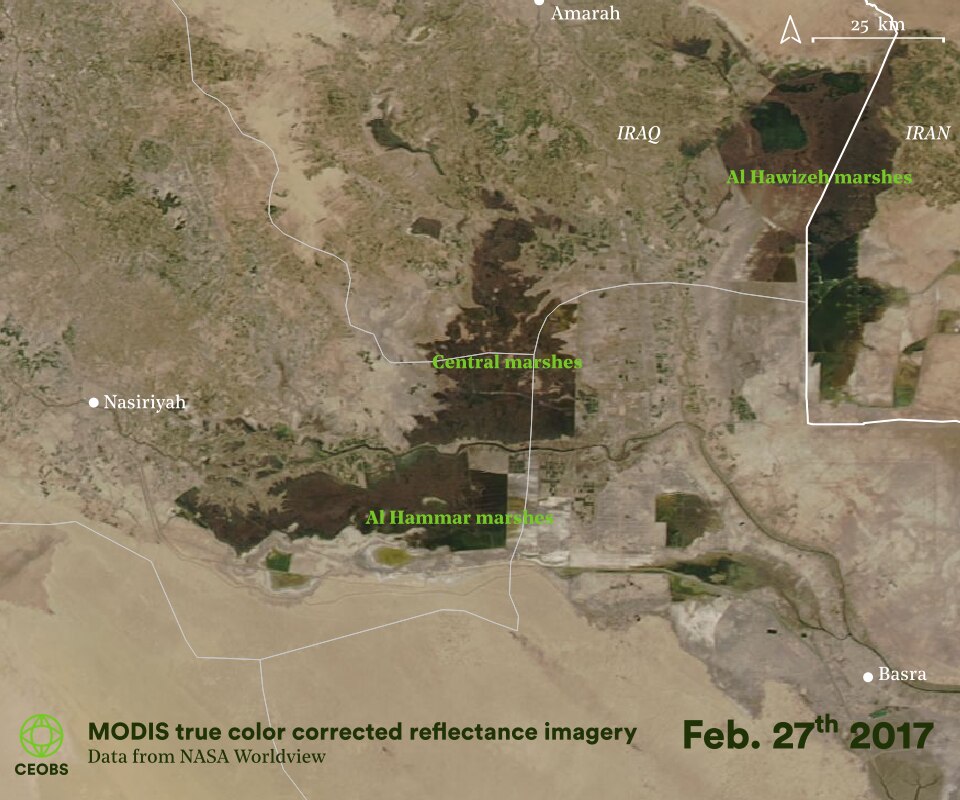

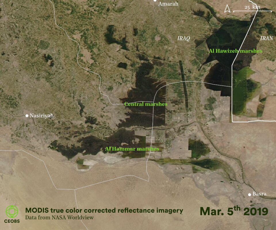
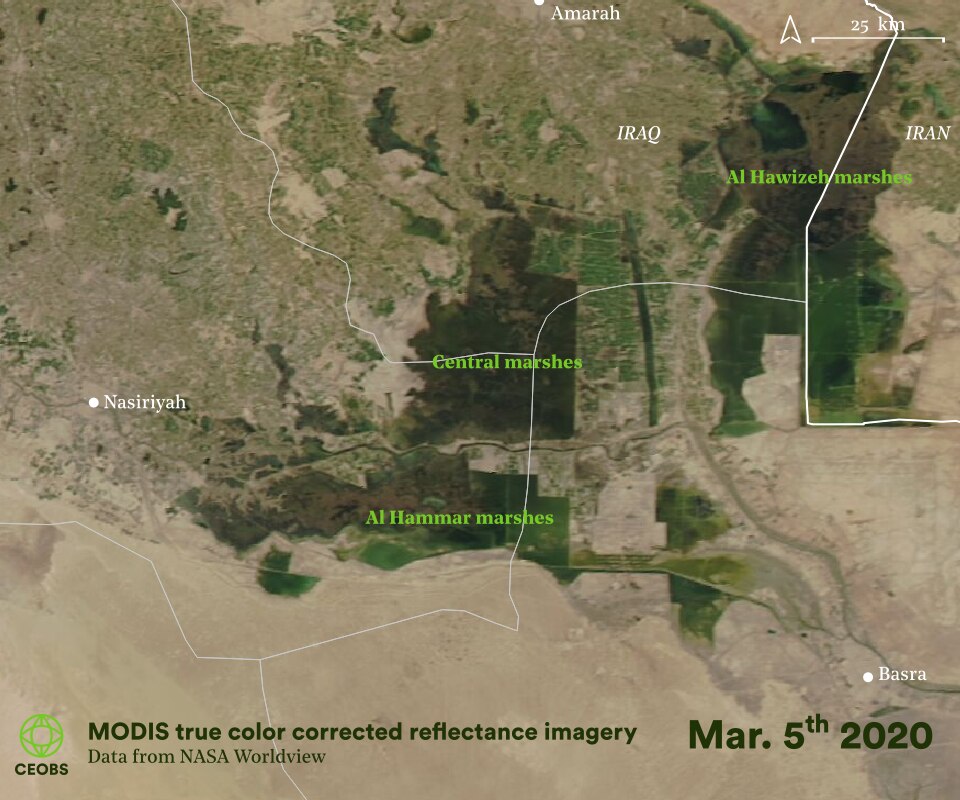
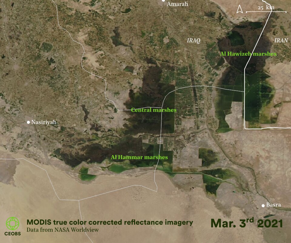
Figure 14. Annual springtime satellite imagery in the marshes from 2000 to the present day, from the MODIS instrument onboard the Terra (1999 launch) and Aqua (2002 launch) satellites. Hover over image to pause animation.
For most of the following decade, the marshland vegetation extent has remained stable, following the peak in 2007 after the rapid growth between 2003-2005. Against rising threats from conflict-related pollution and water insecurity, the Marsh Arabs continued to return – this included government support for infrastructure, and dredging up mud to create 43 islands. These are illustrated in Figure 15, although to date these islands remain relatively free of settlements, and the success of this top-down approach remains an open question.
One contributing factor may have been the stark situation in the extremely hot summer of 2018, where southern Iraq faced a serious drought and water levels dropped significantly. However, the spring of 2019 and 2020 saw vastly increased water levels in the marshes as a result of far above average rainfall. Our analysis found water coverage reached its largest springtime extent since at least the early 1990s, and the largest non-springtime extent since the start of JRC surface water dataset in 1984.2
Overall cultural signs appear positive, with the reappearance of Sumerian boats and growth of water buffalo herding. Recent video footage showing the reflooding of the marshes, and what they look like from the waterways rather than space, was taken by BBC News in September 2020. Furthermore, a recent photo essay in the New York Times painted a picture of serenity and a return to normality.
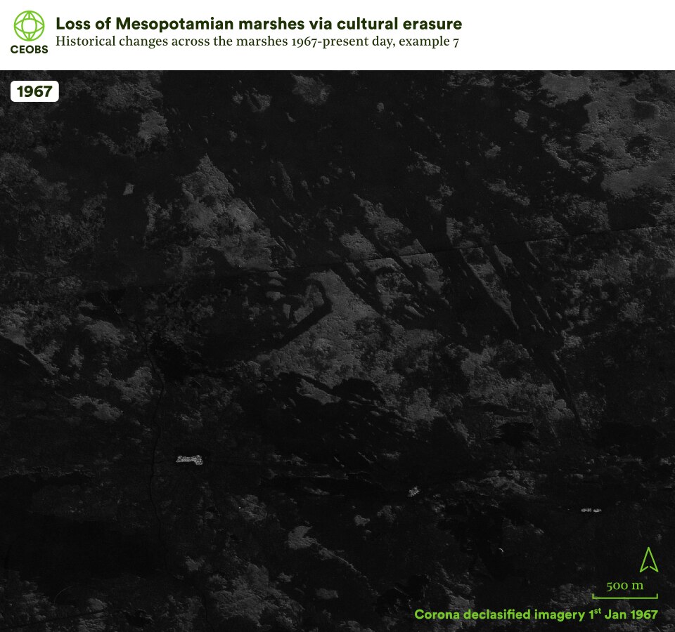
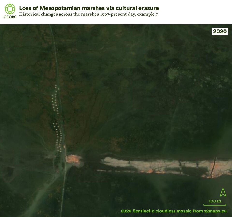

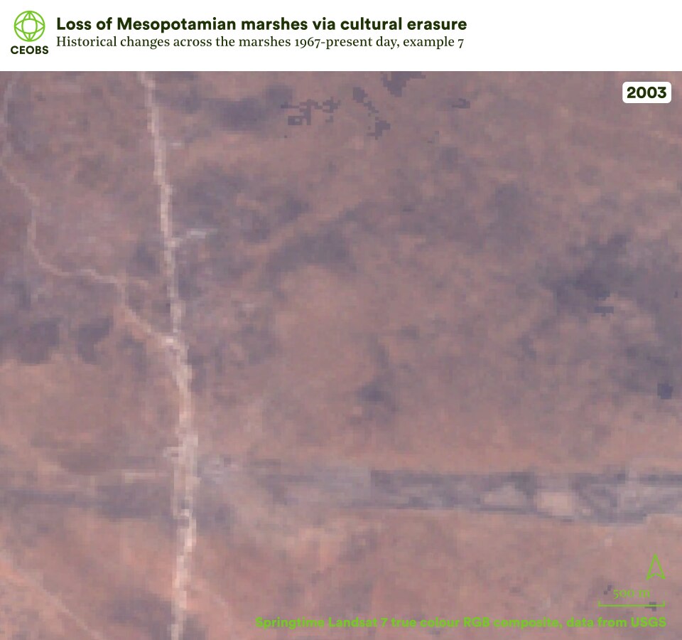
Figure 15. Example location 8, resettlement project in the central marshes, comparing satellite imagery of Mesopotamian marshes in 1967 with that in the subsequent years following land cover change. Use the slider to compare the imagery, and use the left/right arrows to change the year of comparison.
3. New perspectives on the present: Ongoing threats
The widespread reflooding and signs of the Marsh Arab’s return represent a rare good news story, but 2020 may be literally and metaphorically the high-water mark – we now investigate some of the manifold threats to the marshes.
3.1 The availability of fresh water
One big challenge facing the marshes is sustaining the fresh water input to continue to match the reflooded area extent of 2019 and 2020. This is especially the case given the size of the precipitation anomaly in 2018 and 2019, which was the greatest since 1981 (see Figure 16). This has not continued into 2021 – in fact rainfall has been below average for the first half of the year. There are reports that the river levels of the Tigris in Iraqi Kurdistan have dropped by more than half, it is a similar case for the Syrian Euphrates where there have been alarming drops in water levels for the Tishrin Dam.
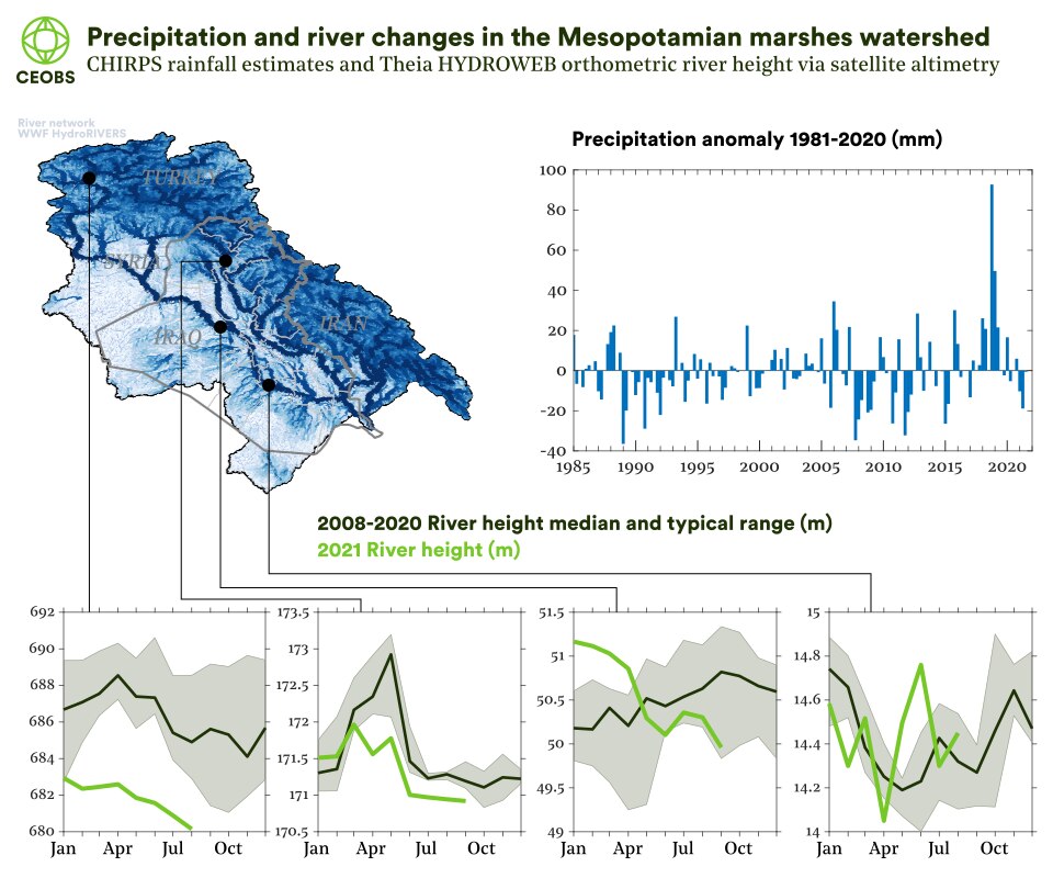
Figure 16. Top panel: Precipitation anomaly over the basin for the Mesopotamian marshes, relative to the 1981 to 2020 average, from CHIRPS precipitation data. Bottom panels: average monthly change in river height (2008-2020) and so far in 2021 for four locations along the Tigris and Euphrates, from satellite altimetry data accessed via the Theia HYDROWEB platform. The map illustrates the extent and main rivers within the Mesopotamian marshes watershed, based on WWF HydroSHEDS and HydroRIVERS data.
The media reports of upstream drying are somewhat borne out by satellite measurements of river levels via radar altimetry. Of the four historical measurements going back over a decade on the Theia HYDROWEB platform, there is a clear trend from furthest upstream to downstream. The role of climate versus upstream water management is hotly debated. The building of dams in upstream countries, such as the recently completed and filled Ilisu Dam in Turkey, has led to political confrontation, rivalry and environmental disinformation. More authoritative hydrological modelling is urgently required to understand these relationships and help inform burgeoning regional co-operation.
But what do the current water level trends mean for the Mesopotamian marshes? Again, we can track the situation using satellite data. Figure 17 indicates that the water area of the marshlands is already approximately 30% lower in summer 2021 than in 2020. Without favourable precipitation, especially if upstream management plays a significant role, the coming years may once more be difficult in the marshes.
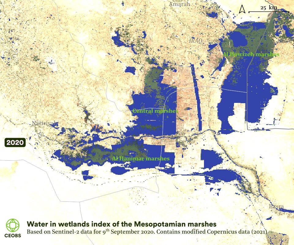
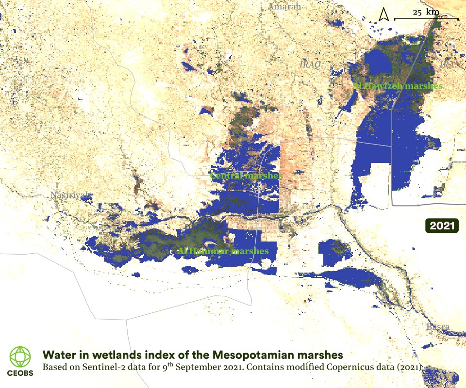
Figure 17. Water in Wetlands Index for 2020 and 2021, using Sentinel-2 satellite imagery as developed by Lefebvre et al., (2019).
3.2 Salinisation
One significant threat facing the marshes and the Shatt Al-Arab is saline water, which is particularly harmful for agriculture and aquaculture, but also impacts a range of industries requiring freshwater including fertiliser, petrochemical and oil facilities.
The most severe salt water intrusion on record occurred in 2018, with seawater reaching 150 km inland. This resulted in a loss of crops worth 30 billion dinars (approximately US$20 million), and destroyed 30,000 trees. There was also mass fish mortality, leading to a loss of livelihoods and complex socioeconomic outcomes that had the potential to lead to political unrest.
Historically the marshes acted as a saltwater source for the Shatt Al-Arab, owing to the significant evaporation from the shallow waters, and so their drainage reduced salt concentrations. However, the inundation of the marshes in 2019/20 did not further increase the salinity of the Shatt Al-Arab – the high levels of water pushed the tidal intrusion downstream. This was welcome, as salt levels in the Shatt Al-Arab had been rising.
The contrast between marshland extent in 2018 and 2019 again illustrates the sensitivity to climate and upstream management, and how in years when river flow is low there is a significant susceptibility to saline water.
3.3 Pollution
Despite the partial recovery of the marshes in the past few years, southern Iraq in general is suffering a freshwater crisis, stymying socioeconomic development, and it results from decades of conflict. There are even worries the water shortages will destabilise the country, already under the strain of exacerbated by COVID-19 and with a growing population expected to double by 2050.
There is a near total reliance on the flow of the Tigris and Euphrates for agricultural livelihoods and irrigation. As these have suffered over recent years, the ability of Iraqis to feed themselves and export food has reduced, leading to loss of livelihoods, migration and further economic strife. The collapse of agricultural livelihoods in northern Iraq was a
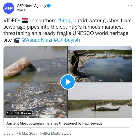
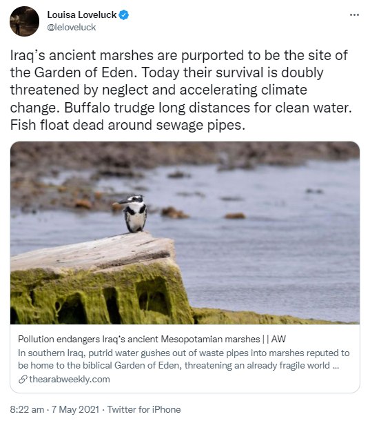
There are many other Sewage releases are a particularly significant threat. In April and May of 2021, widespread releases of untreated sewage were reported in the Chibayish district in the Hammar marshes, near to Marsh Arab settlements. Such releases have clear environmental health implications, in addition to impacting the marshland environment and the livelihoods it supports. Dead fish were visible in video footage of the sewage release, and buffalo were forced kilometres away to drink. However, managed sewage treatment may be one of the ecosystem services the marshes could provide, and one The Eden in Iraq Wastewater Garden project, also in Chibayish district, hopes to pilot.
The oil industry in the vicinity of the marshlands also presents a threat, both through the release or spillage of produced water into soil and water,3 and through air pollution, in particular from flaring. Figure 18 illustrates how widespread produced water is in the area of marshland dried for the West Qurna and North Rumaila oil fields, whilst Figure 19 shows the location of flaring within the marshes. Poor practice within the oil industry remains an ongoing threat to the marshes. The environmental effects of the recently announced $27 billion investment by TotalEnergies at the Ratawi, West Qurna, Majnoon, Luhais and Tuba fields have so far received little attention, the plans include seawater injection into oil wells to increase production, and reducing flaring.
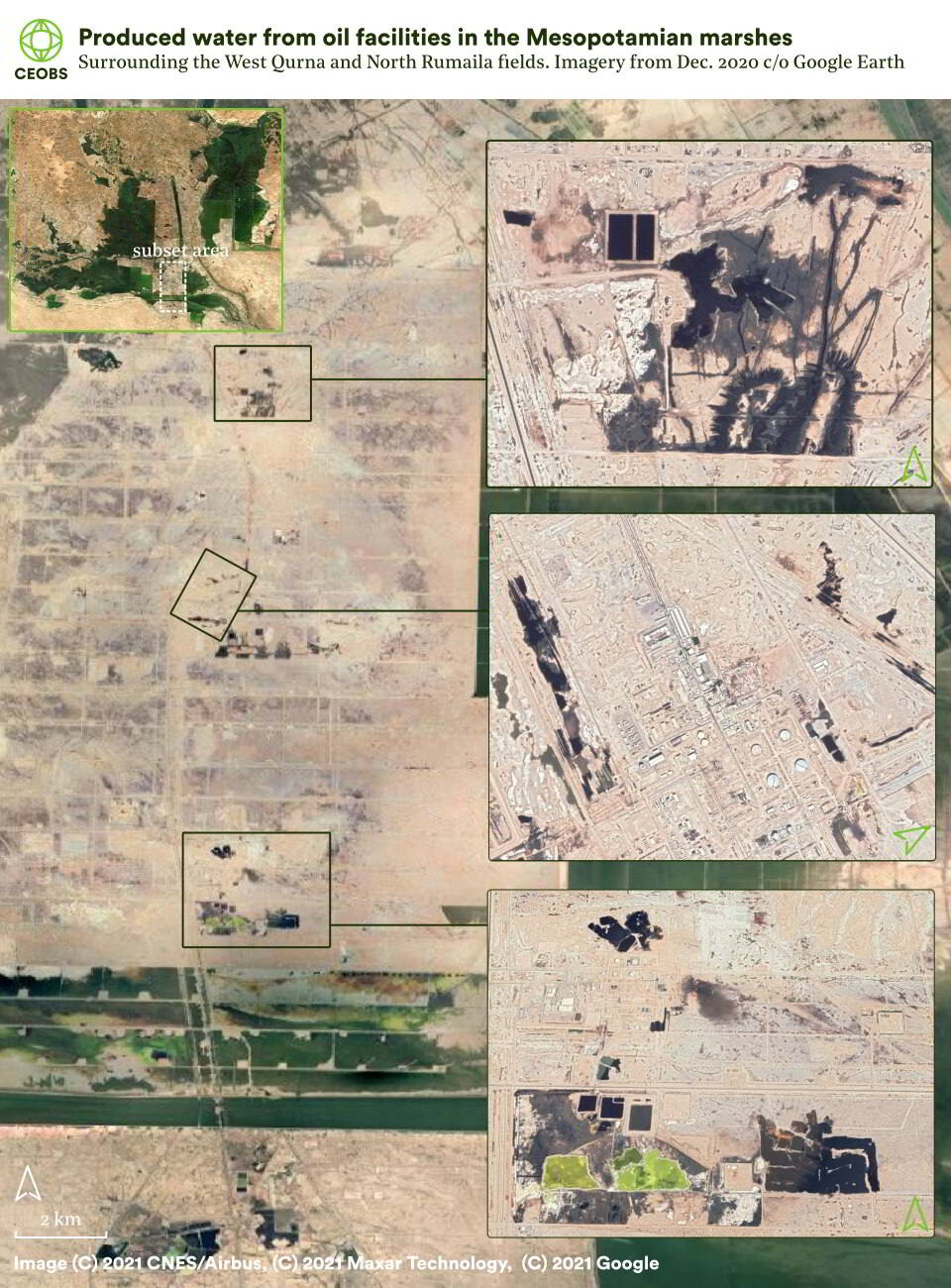
Figure 18. Produced water from the West Qurna and North Rumaila oil fields, visible on the surface of the desiccated marshland landscape from satellite imagery.
3.4 Fire
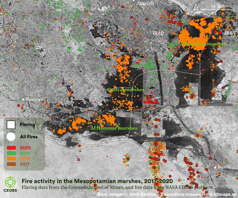
Figure 19. Fire activity in and around the Mesopotamian marshes. Circles indicate landscape fires, and square indicate flaring fires. 2017-2020 flaring data from the Earth Observation Group at Colorado School of Mines, as described in Elvidge et al., (2015). 2017-2020 fire data from Suomi NPP Near Real-Time, processed by the Land, Atmosphere Near real-time Capability for EOS (LANCE) Fire Information for Resource Management System (FIRMS) from NASA.
Figure 19 also illustrates the number of landscape fires, with 2018 being a year of widespread fires of marshland vegetation owing to the drought conditions. These burns resulted in local health issues and a political dispute between Iran and Iraq. Although fires are lit by the Marsh Arabs, 2018 was an unprecedented year. This is indicative of a general trend of increasing fire activity across the whole of Iraq.
Indeed, 2021 is set to be another year of significant fire activity. At the time of writing, there have been large fires in the Al Hawizeh marshes, on both sides of the Iraq-Iran border, with at least 26 km2 of marshland burned between 23rd August and 7th September 2021. Figure 20 shows how clear the burned marshland is from space. It is unknown how these fires will impact the function of the marshes in long-term – to our knowledge there is no academic research for the Mesopotamian marshes, or other wetlands in desert areas, nor the knock-on effects for Marsh Arab livelihoods as grazing area is lost.
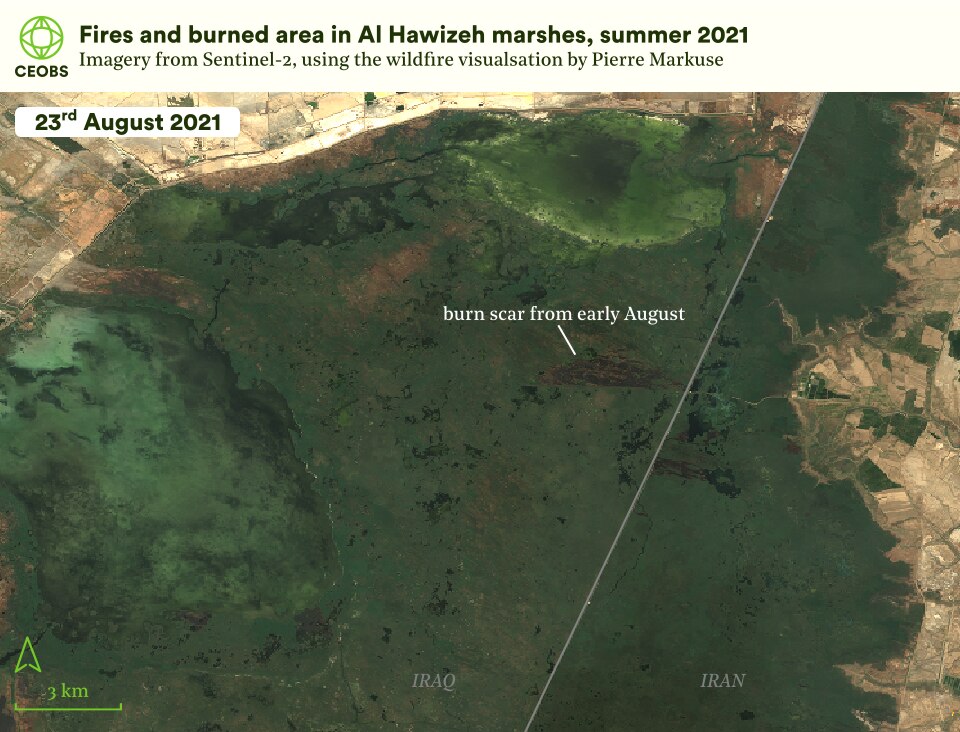
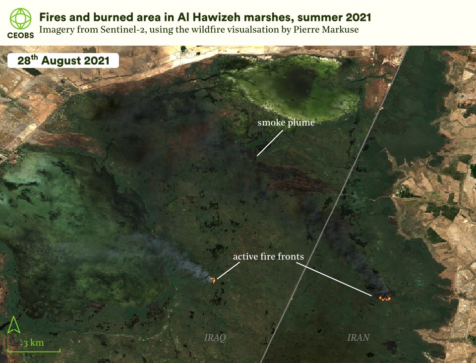
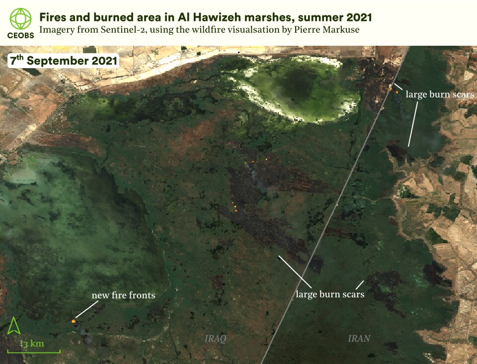
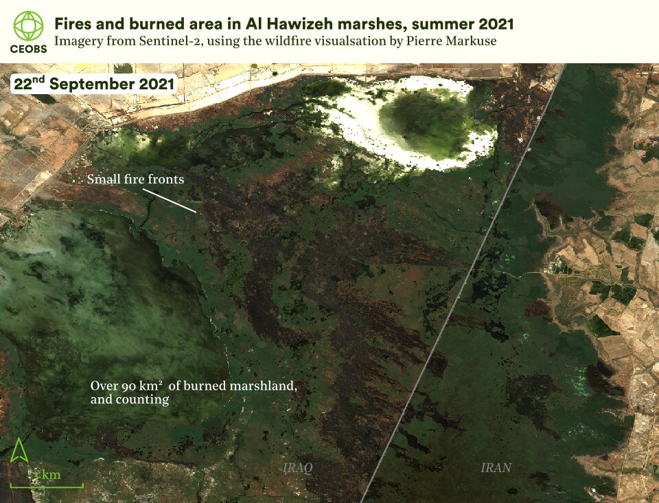
Figure 20. Satellite imagery showing fires and burned vegetation in Al Hawizeh marshes during summer 2021. Visualization of Sentinel-2 imagery using the custom script of Pierre Markuse. Contains modified Copernicus Sentinel data (2021).
Following the decades of conflict there also remains an environmental threat from unexploded ordnance through the leakage of toxic heavy metals, energetic materials or chemical warfare agents. Significant areas of the marshland are believed to be contaminated, especially along the border with Iran and along the former military fronts, in particular the Majnoon oil field.
3.5 Insecurity
A further threat to the marshes is the ongoing insecurity in Iraq. Figure 21 shows the increasing trend in violent incidents within and surrounding the marshes. How the violence manifests into the future may pose an existential threat to the marshes if the security situation deteriorates further.
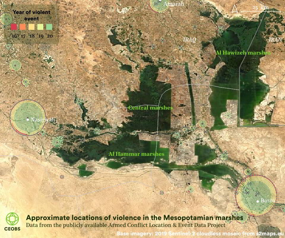
Figure 21. Location and year of conflict events in the proximity of the Mesopotamian marshes. Data from the Armed Conflict Location & Event Data Project (ACLED) database.
4. New perspectives on the future
What next for the Mesopotamian marshes? Despite the reflooding in recent years, challenges lie ahead in preserving the unique landscape and livelihoods, amid climatic, security and economic challenges. As a high value environmental resource in a post-conflict area – what happens in the marshes may be a benchmark for other landscapes in insecure settings.
4.1 Climate threat
Iraq is already feeling the heat from climate change. Following record breaking temperatures of 53°C in Basra last summer, this summer saw a drought reported and was the second driest in 40 years, threatening millions in the north of the country.
In the recent GEO-6 report, Iraq ranked fifth most vulnerable to decreased water and food availability, and extreme temperatures. However, there remain significant knowledge gaps in how climate change will affect the country – this is also true of the Mesopotamian marshes.
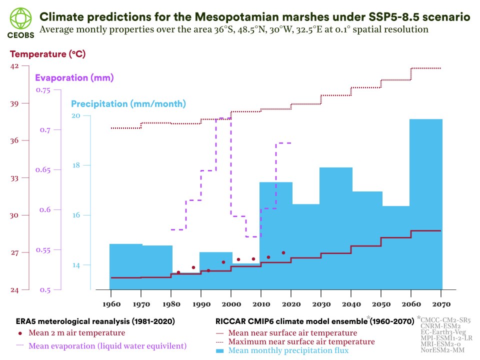
Figure 22. Time-series of temperature, precipitation and evaporation over the Mesopotamian marshes.
We show climate projections for the marshes in Figures 22 and 23, based on the averages of six high-resolution downscaled bias-corrected regional climate models from CMIP6,4 kindly provided by RICCAR.5 The simulations are run under the shared socioeconomic pathway (SSP) 5, which assumes continued development of fossil fuels, with scenario 8.5 representing the highest emissions no-policy situation – i.e. the worst-case scenario.
The temperature results are clear – they will increase, and significantly. Compared to the last decade, by the 2060s the decadal average monthly temperatures will have risen by 1.81°C, and decadal maximum monthly temperature by 3.28°C. These temperature results may at first not seem too serious – only 41.8°C by the 2060s – but because these are monthly average temperatures, they include the cooler temperatures during night time and do not accurately reflect what the maximum temperature over a few days heatwave could be. So, these values are better imagined as a baseline, upon which extremes will occur.
As a crude comparison with last year, the 53°C in Basra would be more like 56°C. This puts temperatures close to what is survivable by humans. Every degree of mean warming is matched by an increase in the wet-bulb temperature, which when above 35°C means we cannot sweat and cool down. Last year in Basra, the wet-bulb temperature reached 32°C, and using the same crude comparison, by the 2060s, wet-bulb temperatures of 35°C are possible. As context, the 2003 heatwave in Europe was characterised by wet-bulb temperatures of only 27°C.
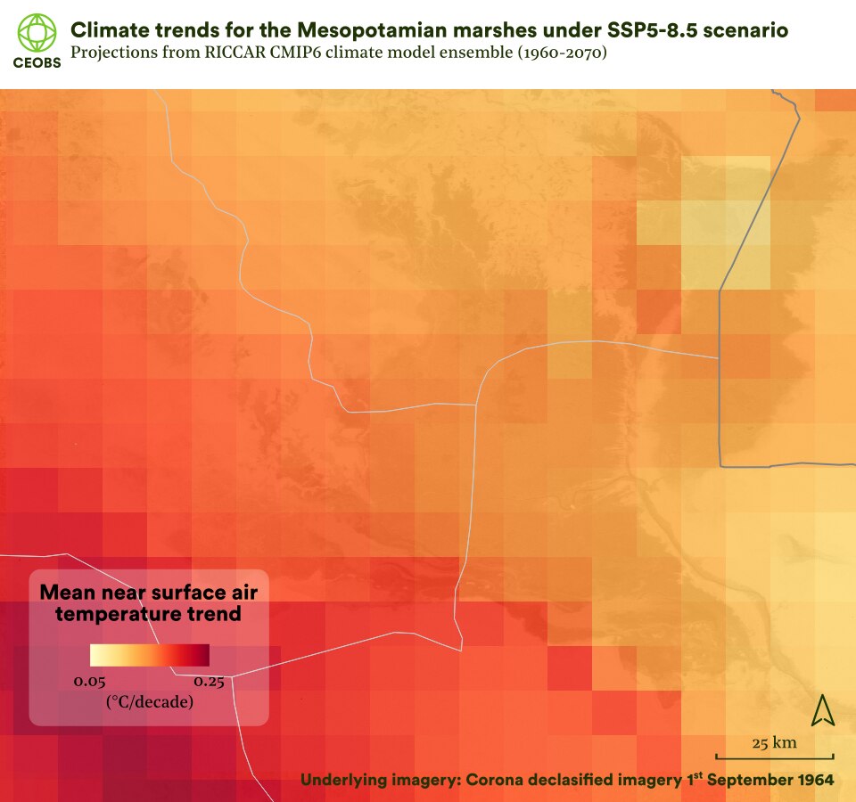
Figure 22. Map of average monthly decadal surface air temperature trend over the Mesopotamian marshes 1960-2070.
The temperature trend is less severe over the marshes than the surrounding desert, and especially so over the deeper lakes of Hawizeh marsh. Averaged across the whole year, wetlands at tropical latitudes have been found to have a cooling effect, whilst in a large Californian delta the air temperature over the wetlands was up to 5.1°C cooler than nearby cropland. Thus, the ecosystem services provided by the Mesopotamian marshes may be particularly important in the coming years as temperatures become unliveable – this makes their preservation and rehabilitation even more important.
To test benchmark the temperature increases against observations, Figure 21 also includes data points based on reanalysis data since 1981, and the same trend is observed.6 This reanalysis data also includes evaporation, which reveals intriguing changes – whilst the marshes were being drained in the 1980s and 1990s, evaporation was increasing, but following the reflooding a steep decrease occurred in the 2000s, before a rise in the past decade.
Interpreting this data is difficult – what is the role of climate, drainage changes and vegetation change – and just how reliable is the data anyway? Evaporation from wetlands is generally site-specific and temporally-variable. Sometimes vegetation cover reduces evaporation compared to open water, whereas sometimes it is greater. One of the main threats to wetlands worldwide is said to be ignorance. We could find no data on the evaporative behaviour of the Mesopotamian marshes – one of the legacies of conflict that still needs addressing is diminished in-situ environmental data collection. Not knowing if rising temperatures are to cause increased evaporation and thus an existential risk to the marshes is a major knowledge gap.
There is a projected trend for increasing precipitation over the marshes by about 25% by the 2060s – a positive sign for their survival. However, it is basin-wide rainfall that is likely more important in the water-balance of the marshes, and some projections indicate a reduction of precipitation in Turkey and Syria.
Together, the uncertainty and unknowns outlined so far indicate the urgent need for more work on the future of the Mesopotamian marshes under different climate and upstream management scenarios. One way to achieve this is through regional hydrological modelling that couples the climate and atmosphere with the terrestrial water cycle, through models like HydroJULES. To our knowledge, no such modelling has yet been undertaken. These approaches could also include an integration of groundwater resources – which have fallen significantly during the last decade, and are an important part of the hydrological system. Modelled scenarios could also include indirect climate threats to the marshes, such as increased upstream use by agriculture. Recent reports suggest climate change is already hitting the competitiveness of Iraqi farmers.
The data collection and modelling approach we advocate here could be developed under the recently launched National Adaptation Plan, which aims to identify and assess knowledge gaps that are barriers to effective long-term climate planning.
The contribution that biophysical changes to the marshes and southern Iraq may make to climate-related insecurity remain uncertain and not extensively discussed, but they have the potential to be a significant threat multiplier in a country where the population is expected to double to 80 million by mid-century.
4.2 Ecotourism as a sustainable solution?
If developed considerately, eco-tourism could help protect and rehabilitate the marshland ecosystem,7 maintaining its ecosystem services and preserving cultural heritage, whilst creating new sustainable livelihoods for disenfranchised Iraqi youth.
However, to date, there has been relatively little tourism in the marshes,8 and despite repeated UNESCO requests to “develop and implement an overall tourism plan” with “sustainable […] practices, infrastructure and facilities”,9 the Iraqi government has not done so.10
There is a burgeoning eco-tourism sector – the typical day involves hiring a local to paddle a reed raft downriver, followed by lunch in a mudhif guesthouse. The US$2 m UNDP and Un Ponte Per Sumereen project was recently established to create shops, parks and displays, alongside capacity building. In light of this increased funding, we considered two alternative eco-tourism approaches to address the key challenges facing the sector: Covid-19,11 marshland interannual variability,12 insecurity,13 and the traditional model of eco-tourism.14 Our approaches are summarised in brief here and published in the journal of the Iraqi marshes organisation by Zeyad Ahmed.
Eco-tourism citizen science
Incorporating citizen science into eco-tourism could be educational,15 useful for monitoring, and provide a sense of environmental stewardship. Such a participatory approach may give tourists a greater stake in, and provide valuable data to help ensure, the health and future protection of the marshlands.
Tourists could choose the activities that they are most interested in, be that biodiversity surveys, water quality sampling or something associated with archaeology. The development of these low-cost and low-resource citizen science approaches must involve co-creation with the Marsh Arabs and a burgeoning civil society, for example Save the Tigris, Waterkeepers Iraq, Nature Iraq, and the recently launched youth-led Marshes Advocates Network.
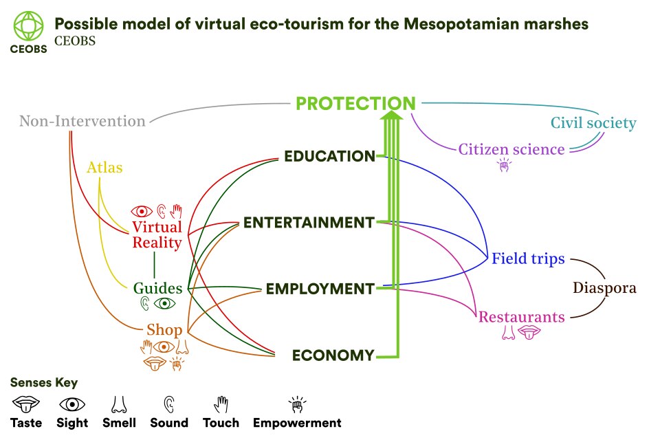
Figure 23. A potential novel model for ecotourism in the Mesopotamian marshes
Virtual eco-tourism
Our project conceptualised a model of virtual eco-tourism that aims to provide an engaging and interactive touristic experience that is provoking and emotional (Figure 23). We sought for it to feature as many of the human senses as possible, whilst helping to educate and grow the local economy – all key to ensuring the ongoing protection of the marshes.
We envisaged tourists using a virtual reality headset and digitised marshland landscape to travel in a boat along the marshes, whilst speaking to a real tour guide in Iraq, buying locally produced reed woven goods, tasting and smelling authentic cuisine prepared by diaspora, and even partaking in remote citizen science using camera traps and satellite imagery. On the horizon technology may even allow one to feel the reeds or water via haptic technology, the wind, the scents, or go for a walk.
Done well, virtual eco-tourism potentially democratises the sector and, by removing financial and accessibility barriers, opens up the experience to a more diverse group of people, and generates more revenue. In general, virtual eco-tourism is a nascent and growing market, no longer seen as a gimmick, with experiences ranging from simple videos through to virtual reality,16 even Amazon has entered the fray.17
Thus far there is no fully immersive virtual experience as conceptualised here, yet with some ambition it could be a success and a trailblazer for eco-tourism in other insecure areas. Before any next steps, consultation and co-design of the virtual eco-tourism model with Marsh Arabs is essential.
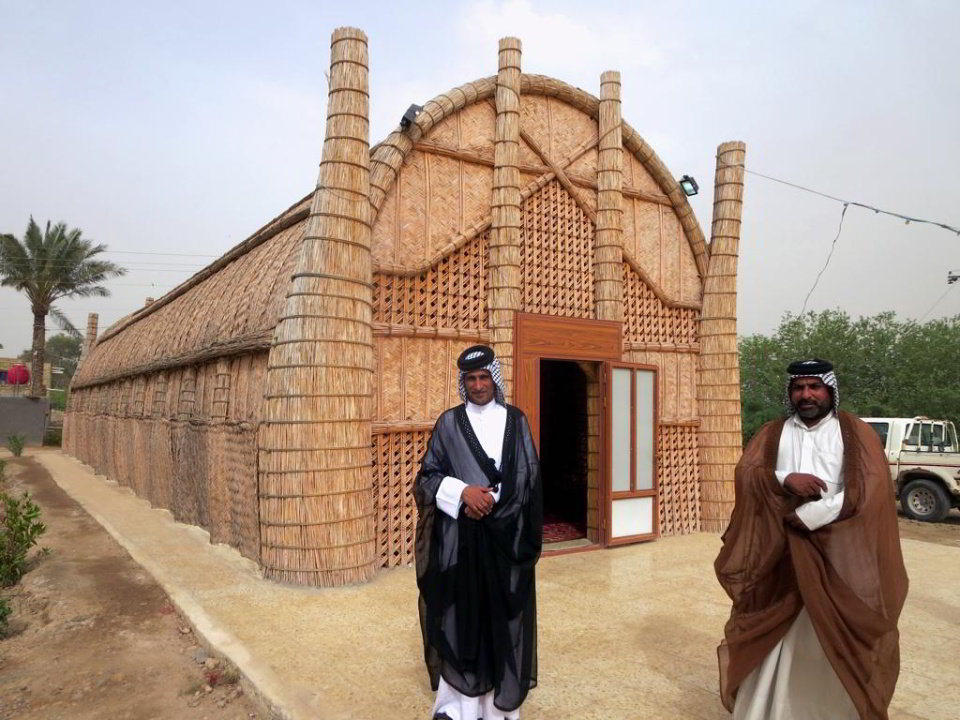
Figure 24. A Marsh Arab Mudhif Reception Hall. Credit David Stanley, Flickr
5. Close
The Mesopotamian marshes have been the subject of much intrigue and research, and are in many ways the poster child for ecocide, with new insights still to be found – as our 1967 comparison imagery shows, bringing to light the scale of the cultural erasure.
As a UNESCO World Heritage and Ramsar site, the marshes ought to be well protected. However, they remain under attack from many angles – water supply and evaporation, pollution, salinisation, oil exploration, fire, governmental indifference and climate change. As one of the most famous and culturally cherished natural resources in a post-conflict setting, if the Mesopotamian marshes cannot be adequately protected, then what hope for similar sites in other conflict-affected areas?
Clearly more work is needed to continue the marshland restoration and ensure new protections are future-proof. There is responsibility both domestically and internationally, and across the spectrum of stakeholders: from local civil society to continue advocating for the marshlands, from academia to ensure the whole hydrological system is understood, from the Iraqi government to regulate water-use and pollution, from the oil-industry to ensure environmental standards are met, and from upstream nations to ensure water is fairly distributed.
The brief perspectives presented here indicate that more focused studies are required, particularly into the climatic future of the marshlands, how it can support more livelihoods through tourism, and how its ecosystem services in regulating a micro-climate and treating waste can be better understood and utilised.
Dr Eoghan Darbyshire is CEOBS’ Researcher. He would like to thank Marlene Ann Tomaszkiewicz from the Arab Centre for Climate Change Policies for the RICCAR climate data, all the other open data providers used, the Nahrein network, Zeyad Ahmed and Raheem Abed Al-Sadoon from the University of Thi-Qar, Jaafar Jotheri at Al-Qadisiyah University, and Mehyar Kadhem at Thi Qar Heritage Organisation.
6. Appendix: Geographic context of the Mesopotamian marshes
Surrounded by arid desert, the marshes are situated in a triangular region of southern Iraq on the flat floodplains of the Euphrates and Tigris rivers. The two great rivers originate in Turkey and flow through Syria before entering Iraq and creating a flat alluvial plain to the south of Baghdad. The shallow slope and narrowing of the plain near the Persian Gulf have caused the rivers to meander, into many branches, deposit silt, and generate complexes of shallow and deep lakes, marshes, and seasonally inundated mudflats. This is particularly true of the Euphrates, and near Nasiriyah the main river channel even dissolves completely into marshes, before remerging more clearly downstream. Springtime pulses of snowmelt are key to replenishing and regulating the dynamics of the marshes. At the town of Al-Qurnah the rivers merge and become the Shatt al-Arab, a more tidal and saline waterway that flows into the head of the Persian Gulf.
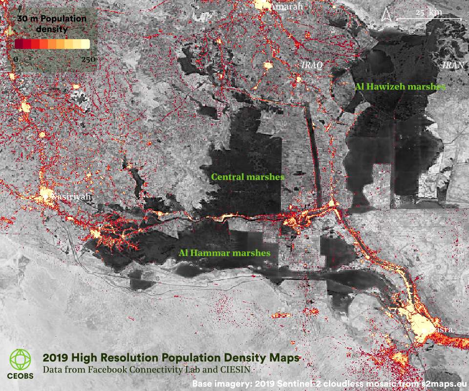
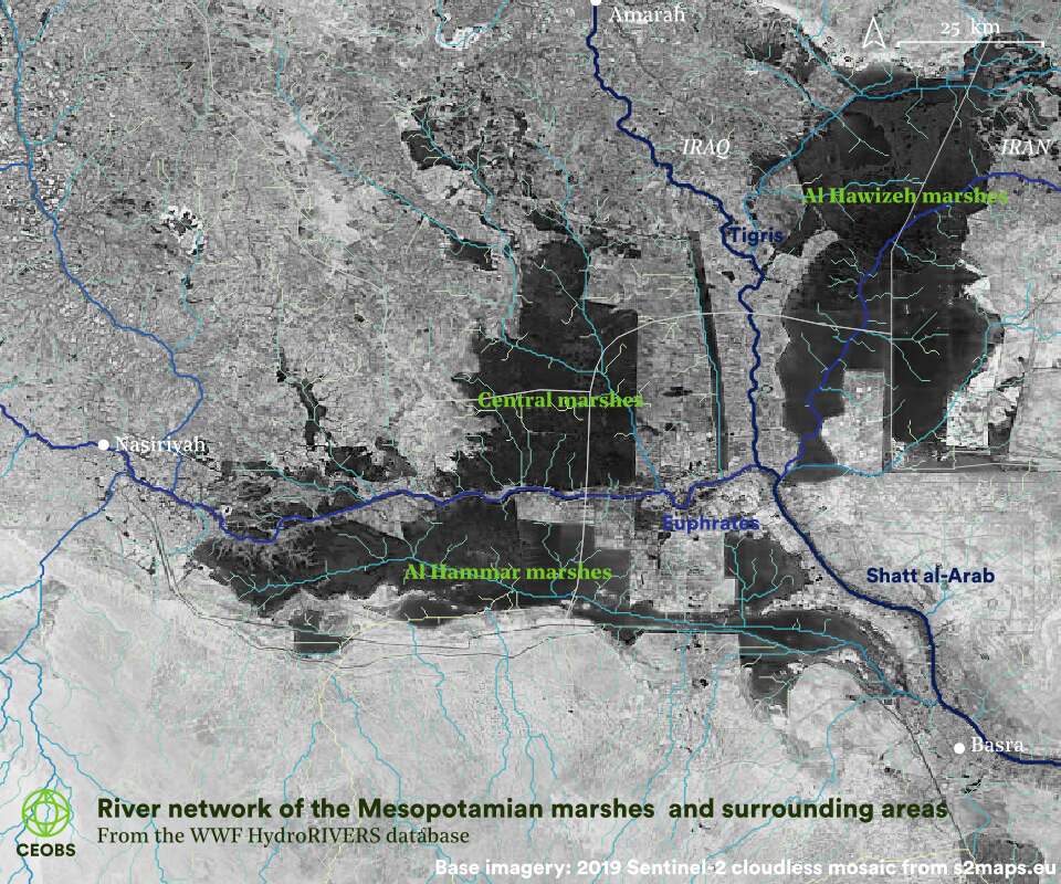
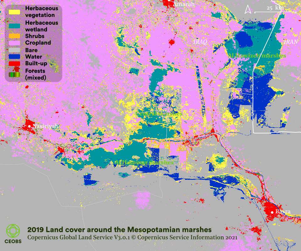
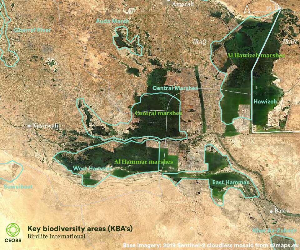
Figure A1. Geographic situation in the proximity of the Mesopotamian marshes, a) 2019 population density, b) river network, c) land cover and d) biodiversity zones.
The marshes – known locally as Al-Ahwar – are bounded by three large cities, Basra to the south, Nasiriyah to the west, and Amarah to north-east. Although a mosaic of nearly interconnected marsh and lake complexes, the marshes are typically subdivided into three distinct areas: the Hammar marsh in the south, the Central marsh between the Tigris and Euphrates, and the Hawizeh marsh to the east of the Tigris and bordering Iran.
The Central marshes are primarily fed by the Tigris and interspersed with many open water bodies, lakes approximately three meters deep (e.g. Al Zikri), characterised by tall reed beds and recognised as the ecological core of the marshes. The Hawizah marshes, fed mainly by the Tigris and Iran’s Karkeh river, has the densest vegetation and the deepest lakes (up to). Approximately thirty percent of the marshes are in Iran, where they are known as the Hawr Al Azim, and is the area of marshland to survive most unscathed. Given its proximity to the sea, the Hammar marsh is more tidal, brackish and eutrophic, creating an ecological niche for marine fish to breed. It is fed primarily by the Euphrates.
Historically, the three marshes were interconnected by chains of seasonal and permeant marsh and lake complexes, especially during periods of high floods, when large tracts of desert would also be under water. However, because of developmental and political landscaping decisions, a number of drainage channels now run between the marshes, as illustrated in Figure A1. In the drained areas, there are now vast tracts of irrigated agriculture.

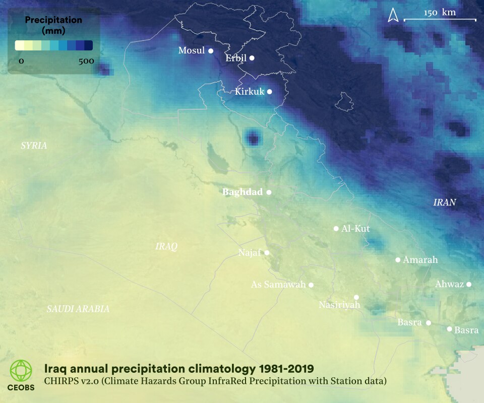
Figure A2. Geographic situation in the proximity of the Mesopotamian marshes a) topography and b) precipitation climatology.
- The raw geotiffs for each frame and the georeferencing points can also be supplied if any researchers want to improve the georeferencing. Analysis was undertaken in QGIS.
- The return of vegetation has not been at the same pace, but it has been increasing, with 2019 having the highest average Normalised Difference Vegetation Index (NDVI) on the MODIS satellite record (since 2000).
- Water is often been used to flood oil wells, in order to increase the pressure and make extraction easier. The water remaining after this process is known as produced water and can be very polluted with oil, heavy metals and brine.
- Coupled Model Intercomparison Project.
- The Regional Initiative for the Assessment of Climate Change Impacts on Water Resources and Socio-Economic Vulnerability in the Arab Region.
- Meteorological reanalysis data is a blend of observations of past short-range weather forecasts rerun with modern weather forecasting models, and offers the most complete picture of past weather and climate.
- According to the International ecotourism Society it is defined as “Responsible travel to natural areas that conserves the environment, sustains the well-being of the local people, and involves interpretation and education”. In other words, it offers a different model to traditional tourism as it minimises impact to the destination, builds cultural awareness and mutual respect, and creates more authentic tourist experiences, where the money spent filters more back to the local communities, aiding economic growth and creating jobs.
- Prior to UNESCO inscription, the 2014 Nomination Dossier stated that the marshes received fewer than a thousand tourists a year – although this number was higher before the 2003 war. Although the marshes are now visited by between 10-20,000 tourists per year, this remains a very small number for such a large area and a UNESCO site – where inscription can often lead to over tourism, especially where used as a marketing tool rather than a route to preservation. The numbers of international tourists is very small, and they are mainly employees of oil companies or Christian pilgrims to Ur.
- In the second and third State of Conservation reports.
- The government tourism website has been offline since December 2016 – seemingly not a priority sector.
- COVID-19 has reduced visits, as elsewhere – threatening livelihoods and conservation progress. How will international travel and the needs of tourists change?
- The risk that interannual variability in the marshland water-level leads to cancellations, disappointments, or prohibitive costs, especially with rising summer temperatures.
- Insecurity poses a disincentive or blockage for foreign tourism. Although not insurmountable – see Rwanda – it feels unlikely in the near-term.
- Aspects of eco-tourism are coming under scrutiny – it may alter wild animal behaviour, decrease biodiversity, or harm indigenous communities, whilst many question the compatibility of carbon emissions from flying and conservation.
- Approaches could include low-tech surveys when wildlife spotting, to high-tech phone apps of games – for example Wildeverse, an augmented reality experience where the citizen scientist can virtually experience forest wildlife.
- For example: 360° videos, e.g. Virtual Helsinki; 360° videos with movement in street-view style and narration, e.g. Google Arts and Culture; Virtual world re-enacting the Battle of Culloden through to modern day archaeology, in association with the National Trust for Scotland; Interactive online eco-tourism tours of locations in Kenya, Uganda, Sumatra and Virunga; Narrated virtual reality videos, e.g. of Iceland’s glaciers; Integration of Google street-view and Wikipedia for VR headsets – Wander; Virtual renderings of iconic locations, e.g. Manco Picchu, for VR headsets with National Geographic Explore.
- Amazon explore – a new platform offering short one-to-one online travel experiences and tours. It incorporates the idea of buying local goods, which can be automatically added to your Amazon basket. Given the companies record, one wonders how much goes to the sellers and into the local economy – there is a danger this model could be the antithesis of eco-tourism. Nonetheless, reviewers have been impressed with the high production value and unique platform, with integrated graphics, maps, labels and conversation with your guide.


