Examples of environmental harm in Ukraine | return to map
Name: Irpin Dam
Location: Kozarovychi, Kyiv Oblast
CEOBS database ID: 10489
Context
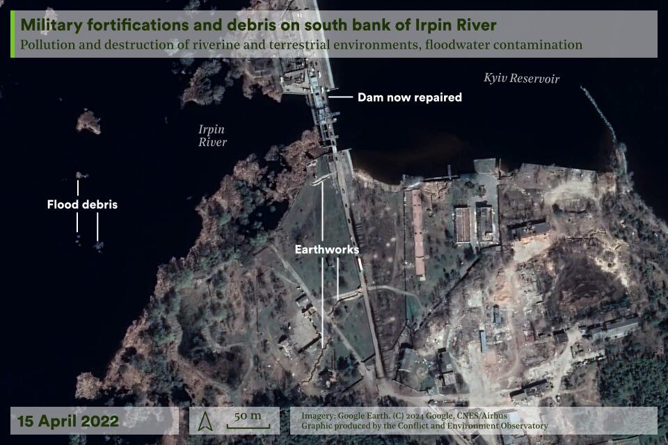
Irpin Dam is located near the village of Kozarovychi, 30 km north of central Kyiv. The dam was built at the point where the River Irpin meets the River Dnipro, which was impounded forming the Kyiv Reservoir. As the level of the Kyiv Reservoir is three metres higher than the Irpin, the dam was built to reclaim the Irpin’s floodplain, allowing water to be pumped from the Irpin into the reservoir.
Timeline of key incidents
The floodplain saw intense battles in the early weeks of the invasion as forces sought to reach Kyiv from the northwest. The River Irpin provided a natural obstacle in the path to the city and the destruction of the dam offers insights into the use of the environment as an instrument of war and of the role environmental risks play in military decision making.
26th February 2022
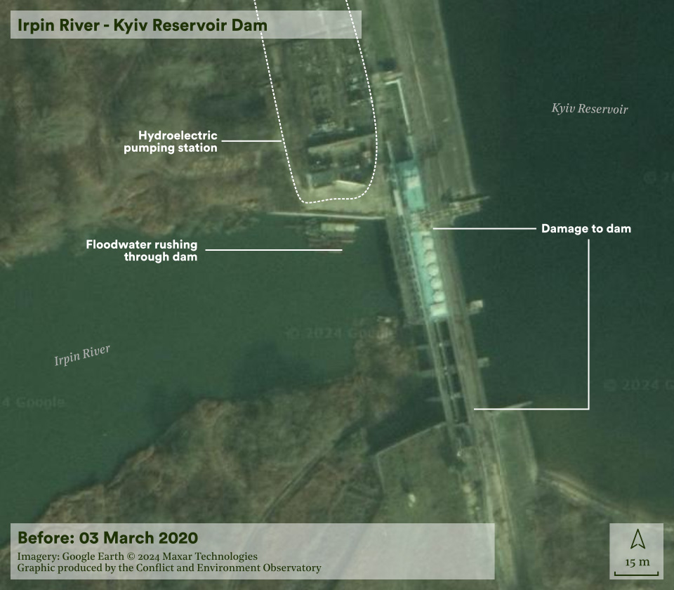
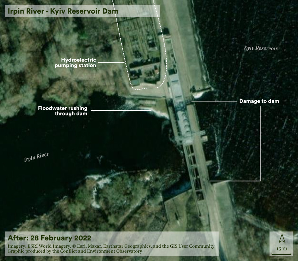
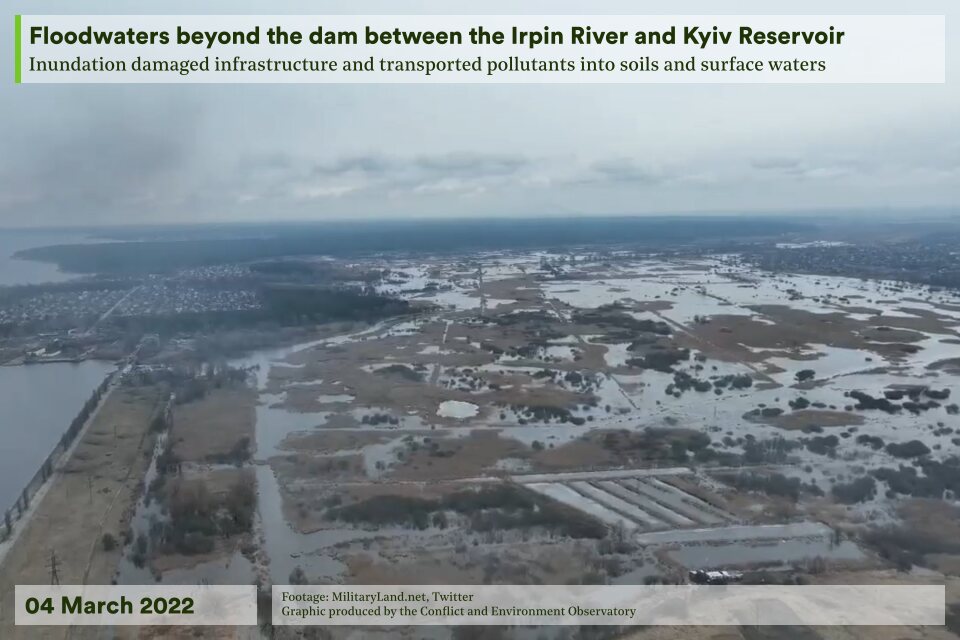
In the opening days of the full-scale invasion, a number of bridges were destroyed in order to impede the movement of heavy military equipment. A decision was subsequently made to flood the Irpin floodplain to render the river impassable and impede access to Kyiv. High water pressure meant that neither opening the floodgates nor destroying the dam wholesale were possible. Instead, a small explosion was used to introduce a steady outflow of floodwater from the reservoir.
On the morning of the 26th February it was reported that the dam breach threatened to flood villages upstream. Satellite radar imagery from the 28th February shows the extent of the initial flooding,1 which whilst severe in the immediate vicinity of the dam, left the Irpin shallow enough for military crossings by the village of Moschun.
5th March 2022
Pontoon bridges had been emplaced across the Irpin near Moschun, enabling heavy equipment to cross. Six days later, one pontoon bridge remained but onwards military movement towards Kyiv appeared likely.
The increased military risk, paired with the fact that the initial explosion reduced water pressure, prompted a reassessment and a larger explosion was carried out to destroy the dam entirely. The floodwaters prevented further crossings, contributing to preventing the capture of Kyiv.
Damage assessment
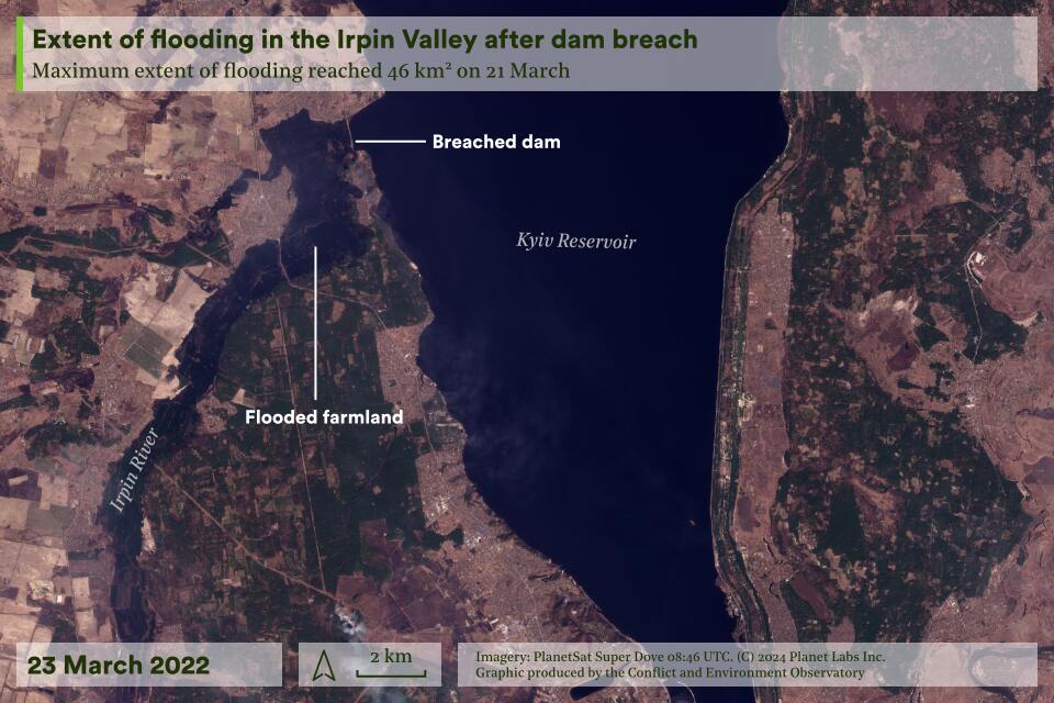
The maximum flood extent was approximately 46 km2 on the 21st March, reaching just south of Moschun, receding to a more stable level of 28 km2 by mid-August. The villages of Dymer and Kozarovychi to the north of the dam experienced some flooding on their outskirts but the most affected settlement was Demydiv, where around 70 houses were flooded.
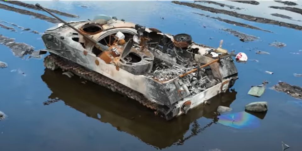
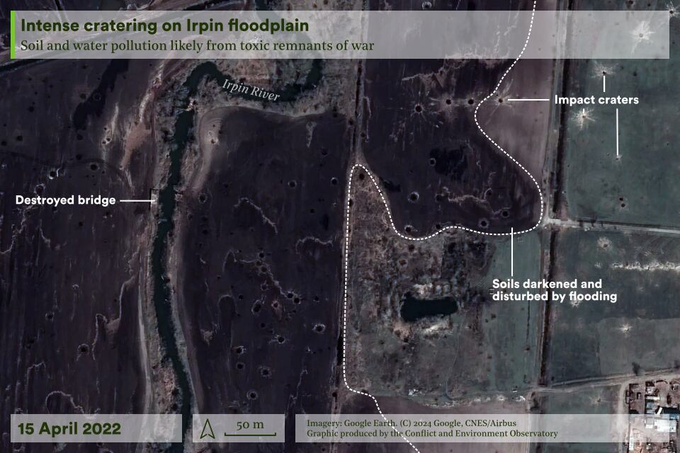
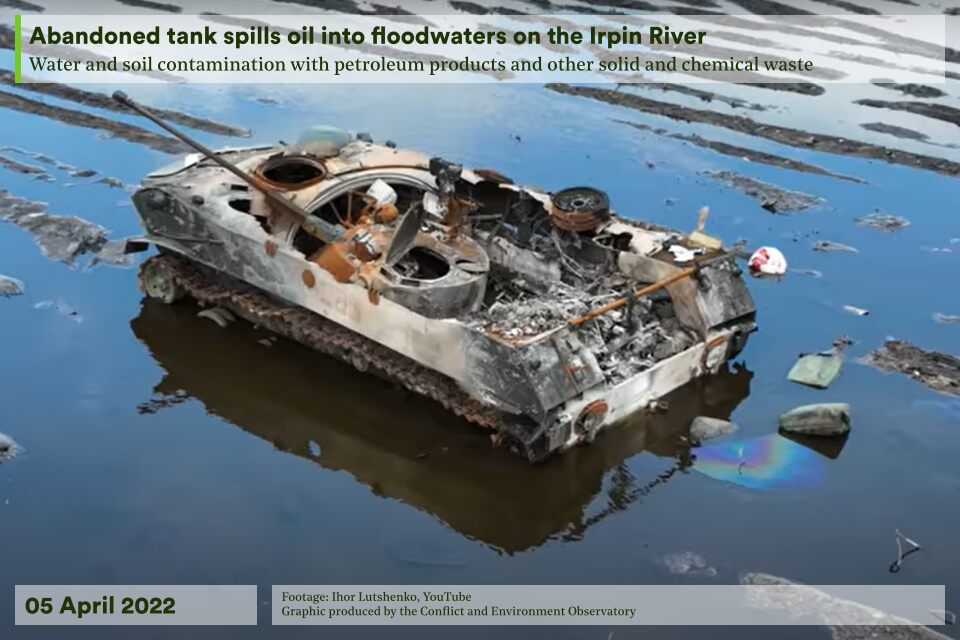
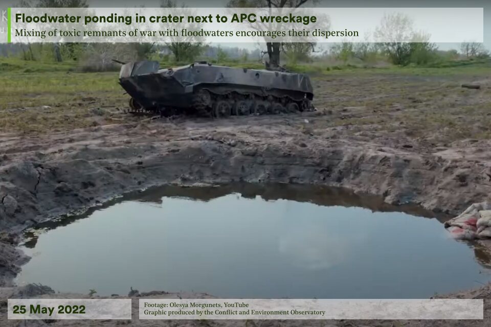
The Irpin valley was left littered with military materiel, particularly from failed river crossings. At least 12 tanks, four heavy vehicles and multiple pontoon segments could be seen in drone footage, together with intense cratering; the presence of mines and unexploded ordnance was likely. Some of the most intense fighting took place in the urban areas in the basin: Hostomel, Irpin and Moschun.
In early 2024 it was announced that the dam would be rebuilt with help from South Korea in order to protect communities from flooding.
Environmental harm assessment
Pollutants mobilised by the flooding in settlements included sewage from household latrines, fuel and lubricants from petrol stations, construction materials from building sites, paints from a metal shop and heavy metals from electrical infrastructure.
Destroyed military vehicles are likely to have released heavy metals, motor oil and fuel, as well as persistent organic pollutants such as PAHs and PCBs. Munitions are likely to have released energetic compounds such as TNT, RDX and HMX,2 in addition to propellants,3 and heavy metals.4 The environmental fate of these toxic remnants of war, especially the energetic compounds, is complex,5 can worsen over time and is dependent on the site of their release.
Longer-term implications
Although in decline prior to February 2022, the Irpin’s wetlands were ecologically important and included in the Emerald Network system of protected areas.6 The valley had four grassland and meadow habitat types and was home to many fish species and migratory birds, including vulnerable species such as the red-footed falcon and lesser white-fronted goose. Local conservationists had long advocated for a planned rewetting of the valley to improve biodiversity.
Limited anecdotal evidence from June 2023 suggested that plant and animal species were adapting to the re-flooded land upstream of the repaired dam but the abrupt return of water to the valley was not the rewetting that conservationists had hoped for and done without the planning required for successful ecological restoration. For example, invasive fish species were likely to have been introduced from flooded fish farms and from the Kyiv Reservoir, whilst the habitat for species that prefer flowing water is now reduced. Ecological monitoring will be needed to track how the habitat is changing.
Dis/mis-information watch
In the days after it was destroyed, uncertainty was rife over who had caused the damage to the dam, with the Ukrainian Prosecutor General’s office stating that the pumping station was destroyed ‘as a result of aggression of the Russian Federation’.
External resources
Ukraine conflict environmental briefing: water | CEOBS and Zoï Environment Network
Return to the country map here.
- Unlike conventional colour or false-colour satellite images, radar images operate at one wavelength, where the strength of the return signal is dependent upon the optical ‘roughness’ of a surface relative to the wavelength. Water is ‘smooth’ and appears dark as the pulse will reflect away from the satellite, while ‘rough’ vegetated areas reflect in multiple directions and are bright, and urban areas create a very bright ‘double-bounce’ reflection. The Sentinel-1 image of the River Irpin shows the large dark region of the Kyiv Reservoir, and the smaller dark region of flooded area where they meet.
- TNT (2,4,6-trinitrotoluene) is used as a booster for high-explosive munitions and is highly chemically stable. This means it can remain in the soil even as UXO casings degrade, having long-term vegetation and human health impacts – high concentrations are still found at WWI battle sites. The US EPA classifies TNT as a possible human carcinogen, and exposure to even low concentrations can lead to long-term health impacts, including abnormal liver function and anaemia. Exposure is typically through drinking contaminated water – the level of groundwater contamination is more significant in sandy soils, whereas in high carbon soils TNT rapidly degrades and so is largely contained to the site of contamination. However, this chemical and microbiological decomposition can produce harmful derivatives, in particular DNT (2,4-dinitrotoluene). DNT is highly toxic, more so than TNT itself, and is listed by the US EPA as a priority pollutant in aquatic environments. RDX, Royal Demolition Explosive (hexahydro-1,3,5-trinitro-1,3,5-triazine) is another chemically and thermally stable compound. It is both less soluble and susceptible to degradation than TNT, and this makes it more likely to migrate through soils and contaminate groundwater. Plants, including crops, take up RDX, yet because they cannot naturally degrade it, they become a potential contaminant redistribution source. This can be through fire, cuttings, or by being eaten – RDX can then start to bioaccumulate in the food chain, posing risks to wildlife and humans. Results from liver and lung animal studies suggest RDX is potentially carcinogenic, though there is no data for humans. It can be toxic when ingested. Structurally similar to RDX is HMX, High Melting Explosive (octahydro-1,3,5,7-tetranitro-1,3,5,7-tetrazocine), which is used in artillery shells and plastic explosives. It is even less soluble, though is also less toxic in the environment.
- Energetic materials contain propellants that include: nitroglycerin, which is relatively safe; nitrocellulose, is highly soluble and can quickly migrate into groundwater though is less toxic than RDX and TNT; nitroguanidine, is similar to nitrocellulose but can lead to eutrophication where degraded by sunlight; and ammonium perchlorate, which causes the most significant and long-term groundwater contamination.
- Heavy metals remain present for significant periods. There still remain high concentrations of copper, iron, lead, and zinc in the soils of WWI battlefields, even in areas not shelled as intensively. There are also high concentrations of arsenic. From more modern battlefields an additional heavy metal contaminant can be depleted uranium (DU), which is radioactive and chemically toxic.
- The transportation and chemical transformations are governed by : 1) the inherent properties of the compounds, like solubility and vapour pressure; 2) the nearby presence of energetics-degrading microorganisms; and 3) the local environment, especially soil type, weather and hydrogeology. Contaminants may partition between multiple media – water, air, soil and biosphere.
- The Emerald Network is an ecological network made up of Areas of Special Conservation Interest. It was launched by the Council of Europe as part of its work under the Bern Convention (the Convention on the Conservation of European Wildlife and Natural Habitats).

