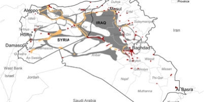
Study revealed the complex relationship between agriculture and land use and conflict.

Socio-economic shocks, technogenic catastrophes, and armed conflicts often have drastic impacts on local and regional food security through disruption of agricultural production and food trade, reduced investments, and deterioration of land and infrastructure. Recently, more research has focused on the effects of armed conflict on land systems, but still little is known about the processes and outcomes of such events. Here we use the case of Syria and Iraq and the seizure of land by the Islamic State (IS) since 2014 as an example of armed conflict, where we investigate the effects on agricultural land use. We apply a reproducible approach using 250 m satellite-based time-series data to quantify the areas under cultivation from 2000 to 2015. Despite a common belief about widespread land abandonment in areas under conflict, results point to multiple trajectories regarding cropland cultivation in the IS seized area: (1) expansion of cropland to formerly un-cultivated areas, (2) cropland abandonment, and (3) decrease of high-intensity cropland. Our study highlights the need to understand these diverse conflict-related and context-dependent changes to the land system.


