WISEN-Ukraine: tracking four years of wartime environmental harm
Published: November 2026 · Categories: Publications, Ukraine, Law and policy
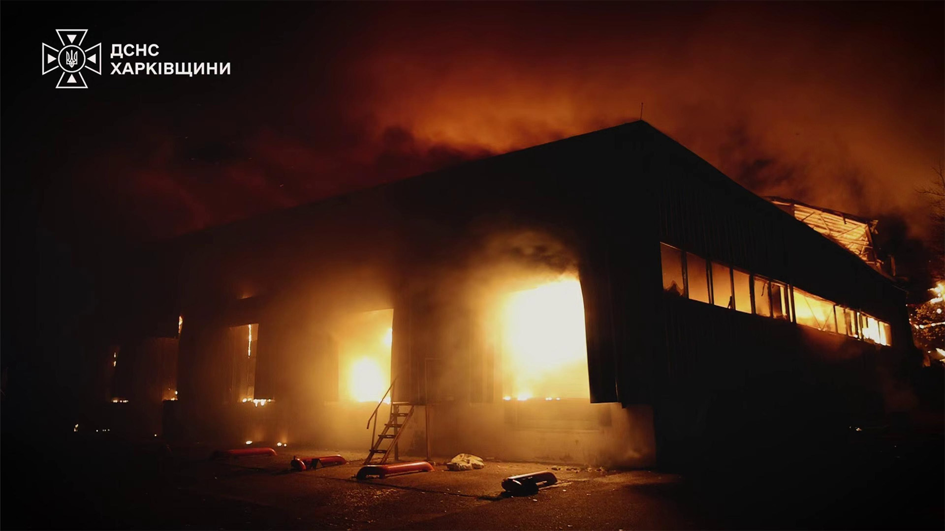
Four years of data from our WISEN-Ukraine database documents environmental harm from Russia’s full-scale invasion that is widespread, severe, diverse and cumulative. Here we examine what’s been damaged, and when, how harm has built up in particular locations, and release the dataset to support recovery, research and accountability.
Key findings
- Harm is widespread and diverse. WISEN-Ukraine has recorded 3,697 damaged facilities, spanning industry, agriculture, energy, transport and military sites. Fires, explosions and leaks at these sites can release fuels, chemicals, fertilisers and explosive residues into air, soil and water, degrading the ecosystem services on which communities and local economies depend.
- Its geography closely tracks the conflict. Nearly two-thirds of damaged facilities (65%) were in occupied territory or within 25 km of the front line. But harm is not confined to the fighting: in cities such as Dnipro, repeated attacks have layered new contamination onto a substantial industrial legacy.
- The toll is deepening, and much of it will persist. Renewed attacks on energy infrastructure since summer 2025 have driven some of the highest levels of assessed risk. Consequences such as groundwater pollution and long-term ecosystem effects may take years to fully emerge.
1. What is WISEN-Ukraine, and what can it tell us?
Four years of full-scale war have caused environmental harm across Ukraine that is widespread, severe and remarkably varied, and much of it will persist long after the fighting ends. Since February 2022, we’ve systematically recorded evidence of this harm through our Wartime IncidentS to ENvironment Database, or WISEN.
WISEN-Ukraine is a consistent record of documented environmental harm and risk: what has been damaged and where, how patterns have changed over time, and which sectors and components of the environment have been affected. It is not complete. Landscape-scale impacts such as deforestation, burn scars and cratering are not included, and some other harms are hard to reliably detect remotely.
In this overview, we use four years of WISEN-Ukraine data to examine the scale, geography, timing and character of that harm. For an introduction to WISEN see here, for the detailed WISEN-Ukraine methodology here.
2. Four years of documented environmental harm in Ukraine
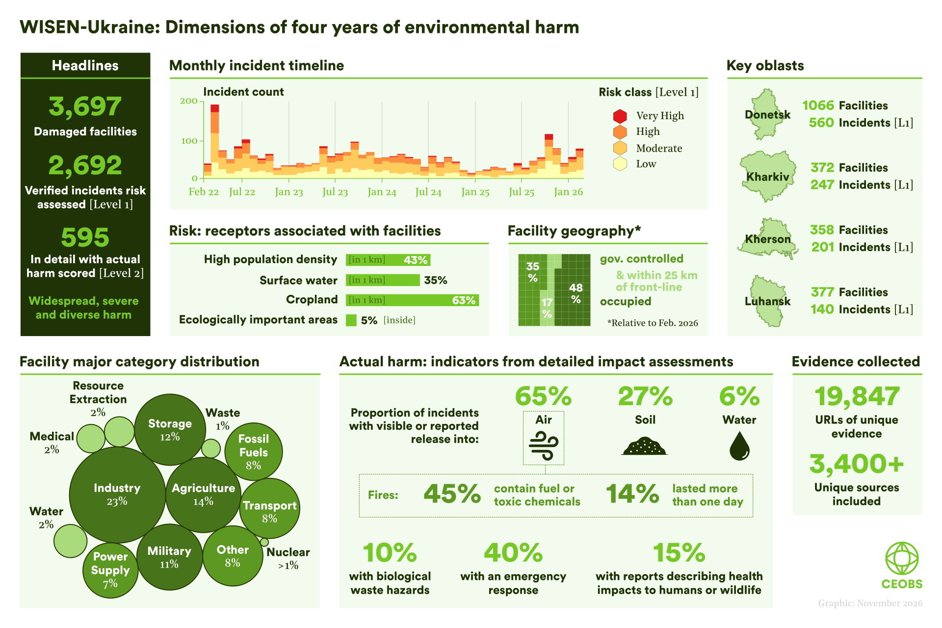
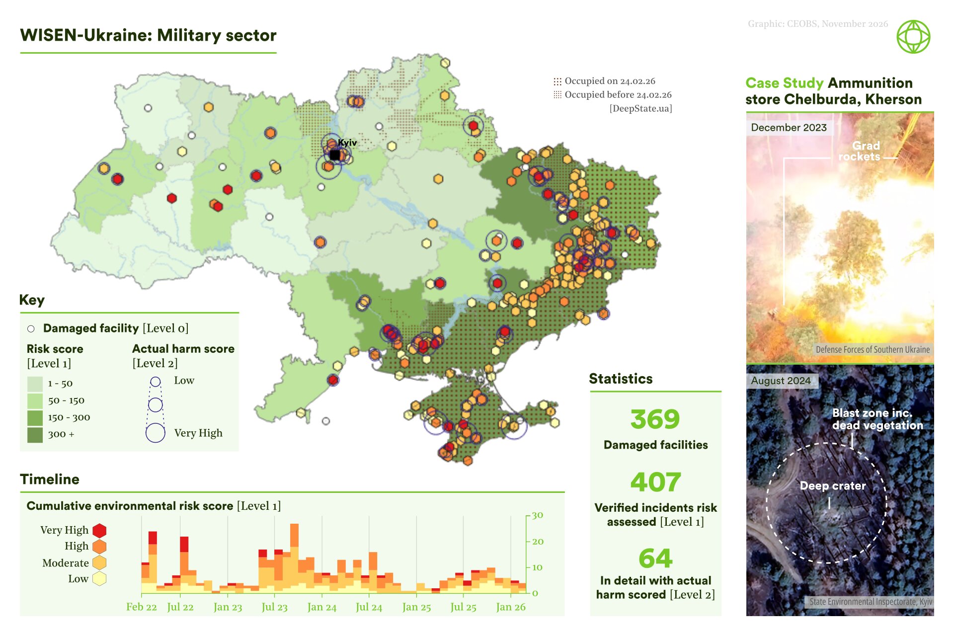
What: By 24 February 2026, WISEN-Ukraine had recorded 3,697 damaged facilities, with 2,692 verified incidents assessed for environmental risk, 595 of which have undergone more detailed assessment of observed or reported harm. Incidents differ in their causes, evolution and consequences, and affect a wide range of civilian, industrial and military facilities.
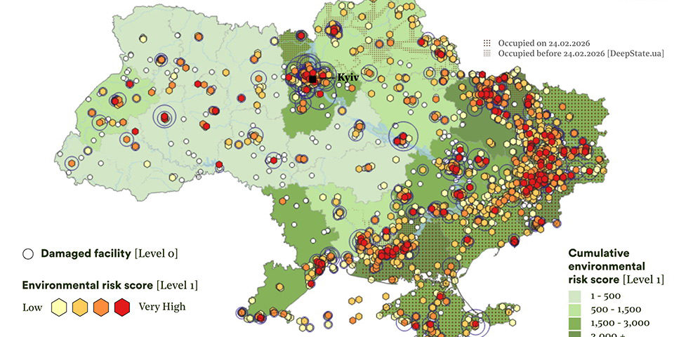
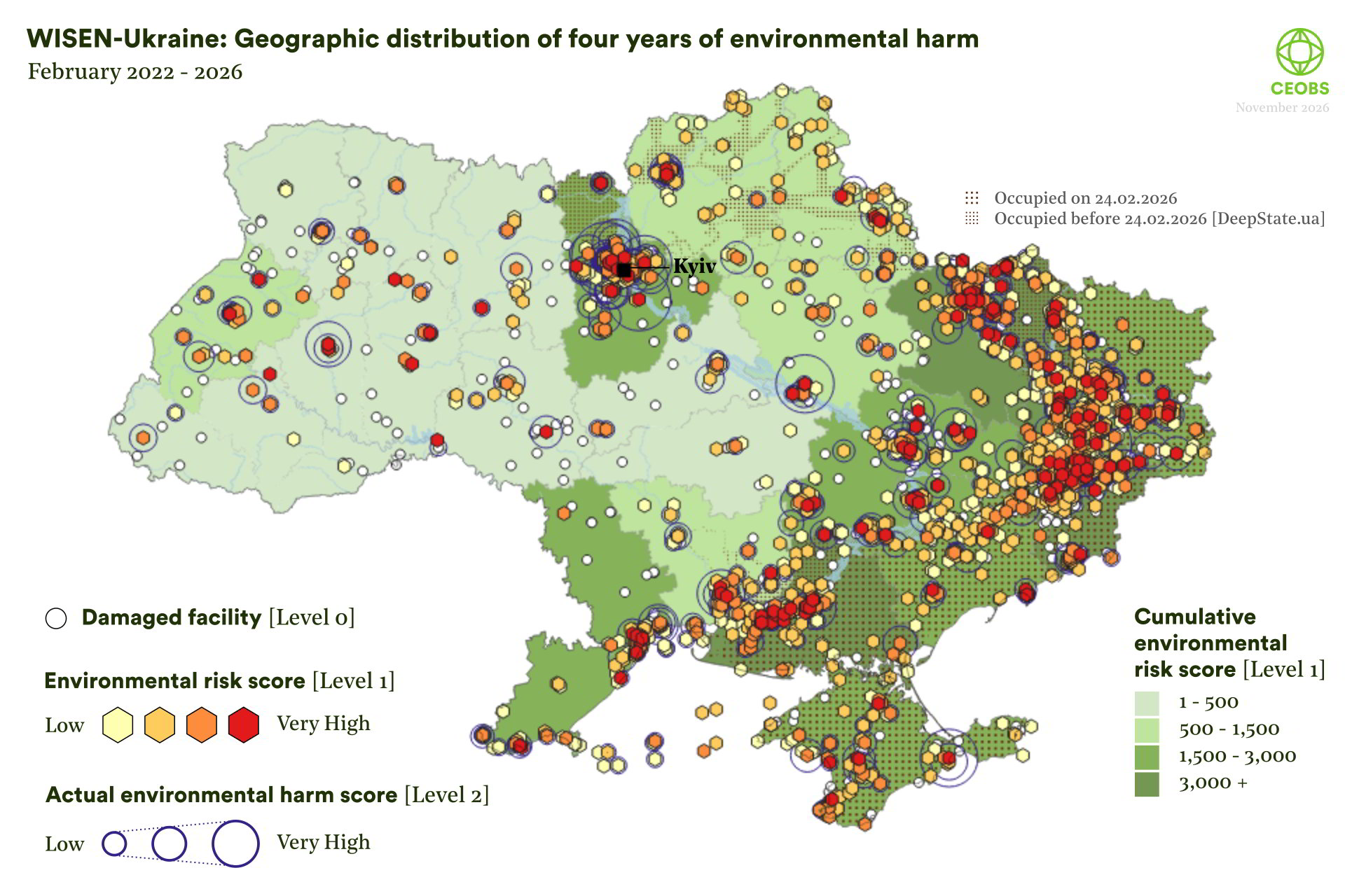
Where: Harm has been documented across Ukraine, but its geography closely tracks the conflict: as of February 2026, 65% of damaged facilities were in occupied territory or in government controlled territory but within 25 km of the front line. Damaging incidents have also occurred far from the fighting – though primarily on land, 80 incidents had been recorded in the marine environment, and 268 within 5 km of the coast.
When: Harm has persisted throughout the invasion. Incidents peaked sharply in the opening months but have continued at substantial levels, with no simple downward trend. Beneath this lie shifts linked to the changing conduct and geography of the war, including periods of intensified damage to energy infrastructure and agricultural storage sites.
Why is WISEN-Ukraine reliable?
WISEN-Ukraine is built on independence, triangulation, transparency and domain expertese. We are not funded by, or answerable to, any party to the conflict. But independence is not distance; our team includes Ukrainian researchers, and combines expertise in conflict and environmental science with Ukrainian sources, language and local knowledge. Automated techniques help flag potential damage but nothing enters the database without manual verification against multiple sources, including satellite imagery and open-source reporting. Thousands of candidate sites have been filtered down to a conservative set of confirmed cases, drawing on nearly 20,000 evidence URLs from more than 3,400 sources and tens of thousands of hours of analysis. The methodology is published and open. It is not perfect: it is resource-intensive, and some methods reflect what was feasible in 2022.
3. Understanding the nature of environmental harm
3.1 What is being harmed? Sectoral patterns
The facilities recorded are strikingly diverse. Industry is the largest category, with 836 damaged facilities (23%), followed by agriculture (511; 14%), storage (458; 12%) and military sites (393; 11%), with transport, fossil fuel and power infrastructure all accounting for substantial shares. Prominent facility types include electrical substations, ammunition stores, agricultural warehouses, livestock farms, grain stores, fuel depots, petrol stations and bridges. Some of the most publicly prominent risks are comparatively rare: only six nuclear facilities appear in the dataset. How often a type of facility is damaged is not the same as how environmentally significant that damage is.
Sectoral trajectories also differ. Damage to fossil fuel and non-nuclear energy infrastructure has persisted throughout the invasion, but rose markedly from summer 2025, with particularly high assessed risk in late 2025 and early 2026. Damage to agricultural storage, by contrast, was concentrated in 2022–24 before falling away. Military incidents have continued throughout, while chemical industry incidents are fewer but include several assessed as causing substantial harm.1
WISEN also includes ten ‘special cases’: high-risk facilities where repeated attacks, changes of control or the volume of reporting made incident-by-incident recording less useful. At the Avdiivka Coke and Chemical Plant, for example, 157 reports of attacks, damage, operational changes and forecasts trace how risks evolved over time. Only ten special cases were defined; the approach was not expanded as the wider WISEN framework matured.2
Combined with knowledge of industrial processes, contaminants, hydrology and land use, these data can help identify priorities for field investigation and recovery. A damaged fuel depot may warrant soil and groundwater assessment; damaged power infrastructure can raise risks from coal ash, heavy metals or PCB-containing equipment; agricultural stores can release fertilisers, pesticides and oils into soils and water. At military sites, contamination assessment must be coordinated with clearance of unexploded ordnance. In this way, WISEN can help turn remote evidence into priorities that Ukrainian authorities, scientists and communities can test and act on.
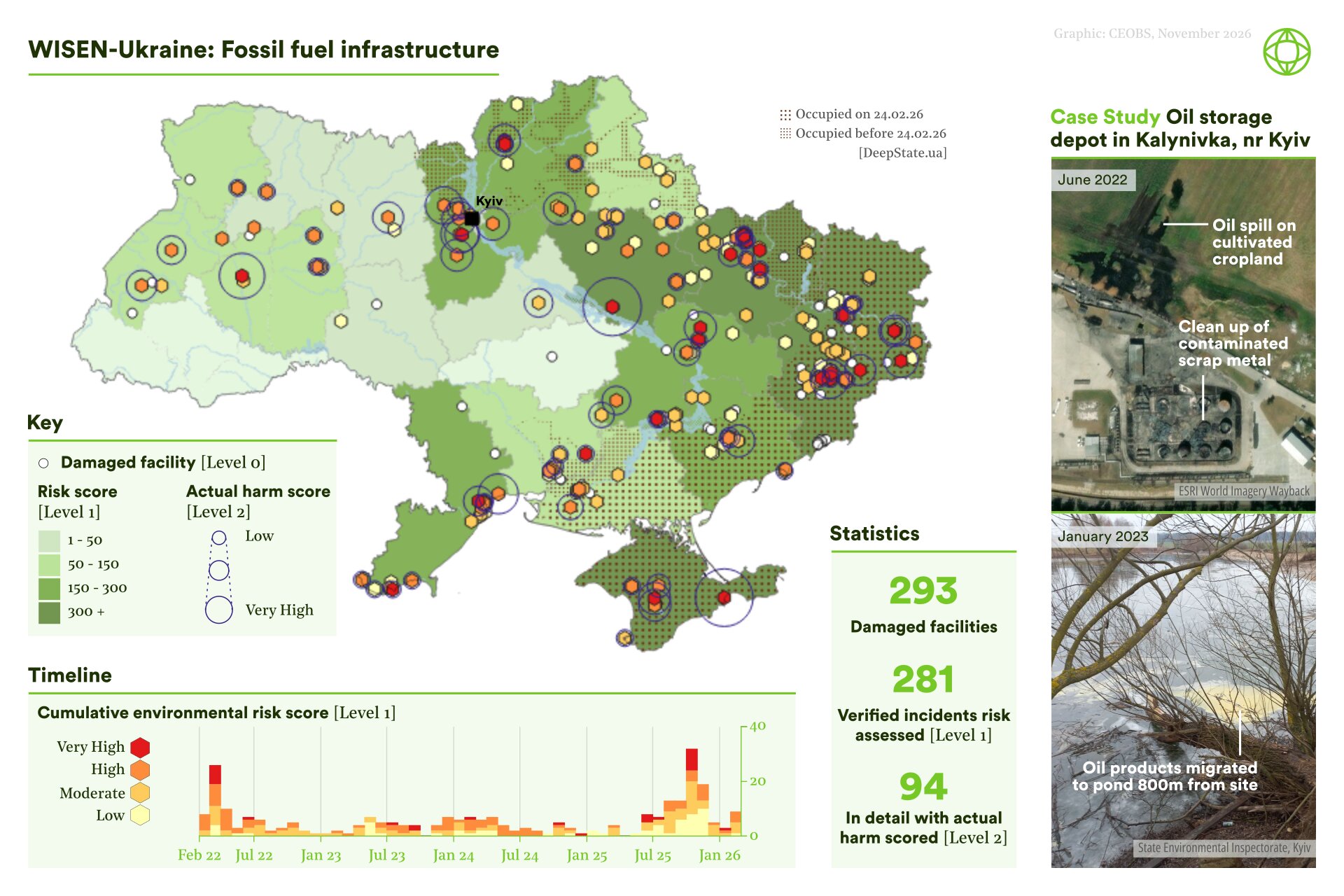
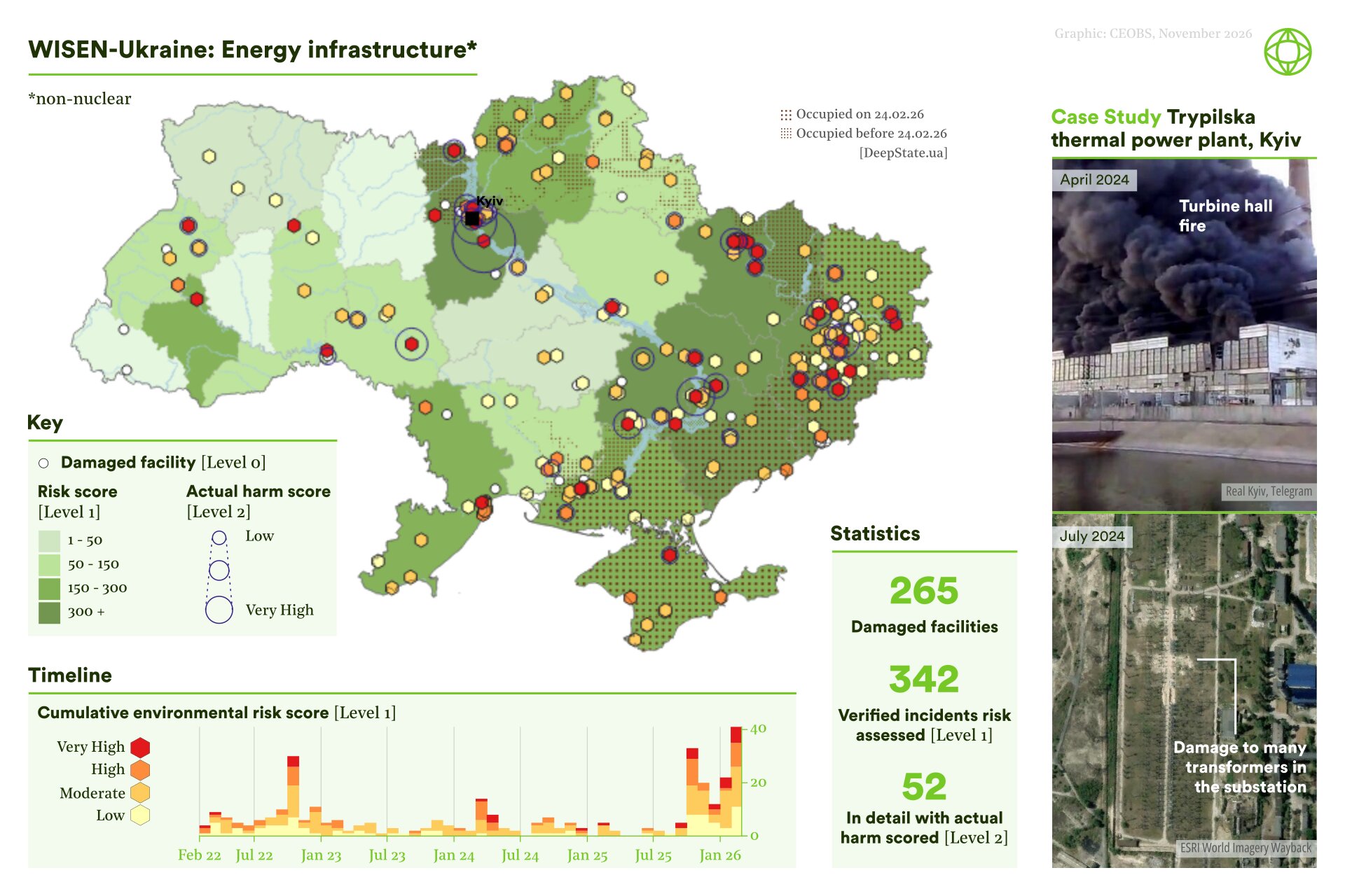
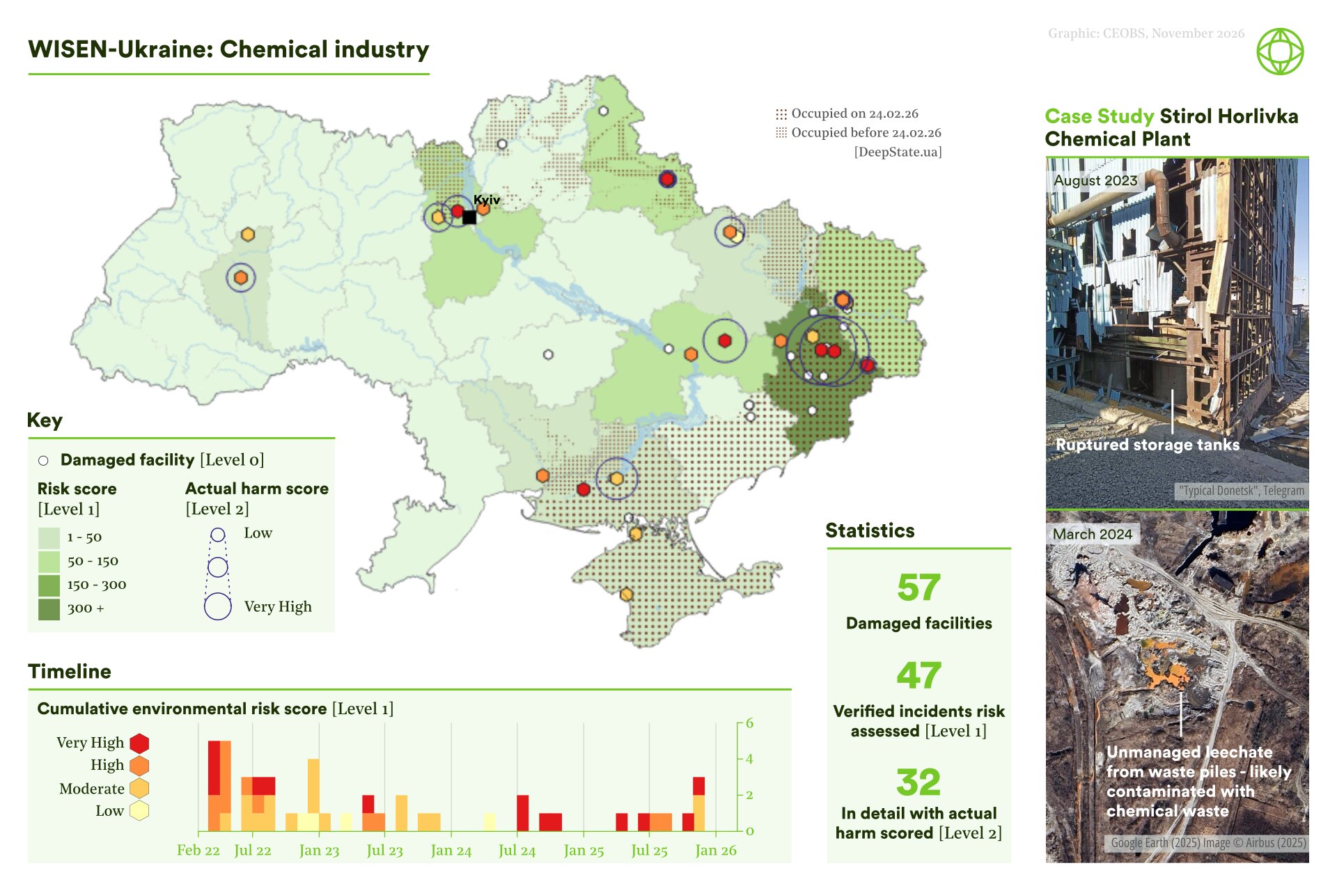
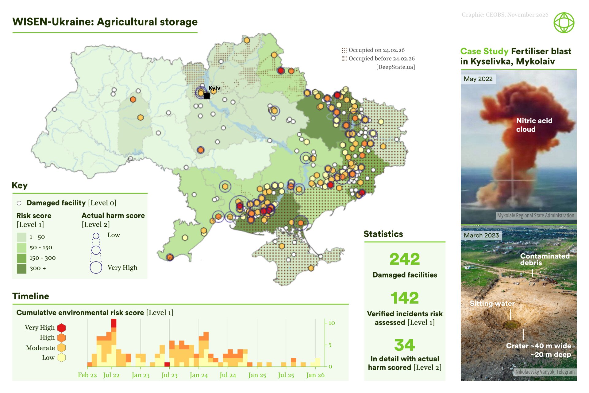
3.2 How does environmental harm accumulate in particular places?
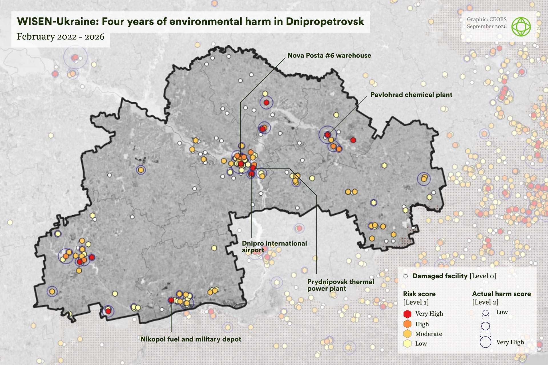
WISEN-Ukraine can also show how harm builds up regionally. Dnipropetrovsk Oblast contains 193 damaged facilities and 115 verified incidents, 22 of them assessed in detail at Level 2. Industry accounts for 22% of affected facilities, followed by agriculture (20%), transport (15%), fossil fuels (10%) and power supply (10%), with livestock farms, electrical substations and machine-building plants particularly prominent. Damage is concentrated around urban centres rather than only along the front line.
This matters for exposure. The oblast has taken in around 500,000 displaced people, many in Dnipro and Kryvyi Rih, and a high proportion of them are older. Dnipropetrovsk ranks third among oblasts for assessed actual harm, and sixth for environmental risk.
How repeated attacks create compound environmental risks
Incident counts alone cannot show how risks build up in particular places. These five facilities illustrate different pathways of repeated, overlapping and cumulative harm across Dnipropetrovsk Oblast: from urban air pollution and contaminated soils to damaged energy infrastructure and long-term industrial legacies.
3.2.1 Nova Poshta warehouse no.6, Dnipro [WISEN L2 ID: I1697]
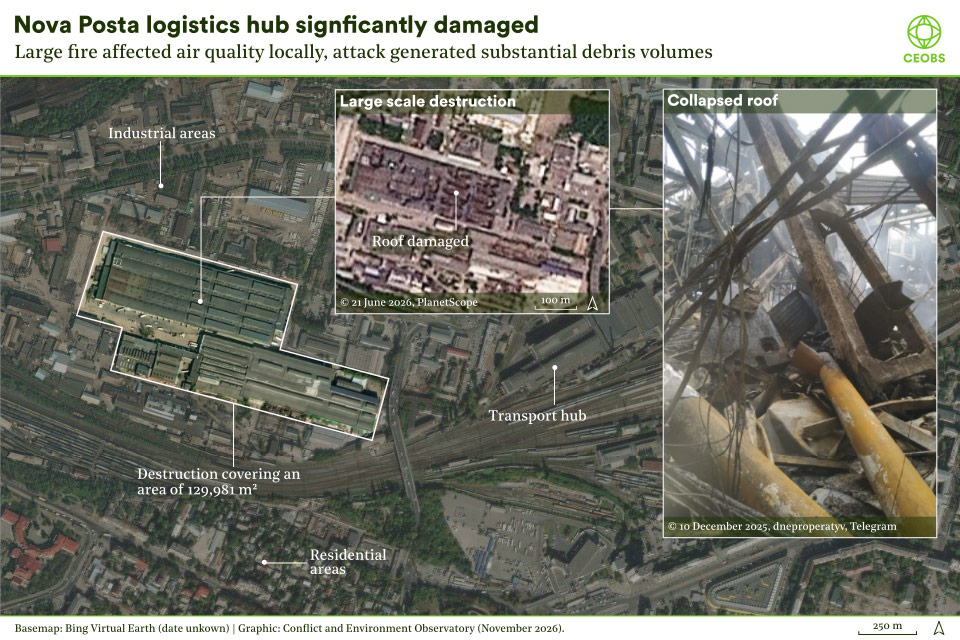
On 6 December 2025, a missile strike destroyed a Nova Poshta warehouse in Dnipro, causing a large fire and a smoke plume across the city. Burning mixed goods can release fine particulates, carbon monoxide, nitrogen oxides, VOCs, PAHs and dioxins; unconfirmed reports suggest medicines for the humanitarian response were also stored there. The site’s proximity to homes, the city centre and the main railway station increased potential exposure and showed how attacks on logistics infrastructure can create complex environmental and public health risks.
3.2.2 Pavlohrad chemical plant [WISEN L2 ID: I1253]
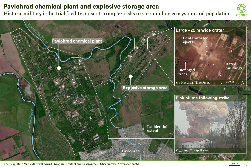
This military-industrial site is associated with rocket fuels, explosives and the disposal of obsolete landmines. WISEN records six Level 2 incidents there. The largest, in April 2023, reportedly struck an explosives storage area and caused a major blast. Another attack in April 2026 produced a large pinkish plume of unknown composition. Repeated damage risks accumulating contamination in soils and drainage systems, with nearby homes and rivers offering exposure pathways.
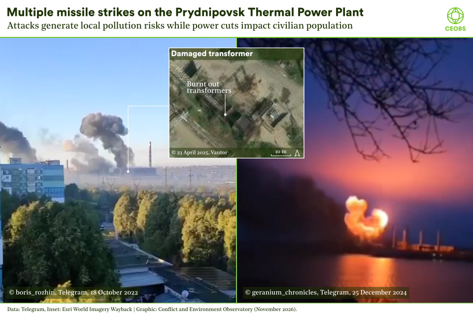
3.2.3 Prydnipovsk Thermal Power Plant [WISEN L2 ID: I1556]
Already a major local polluter before the war, the plant has two Level 2 incidents in WISEN: transformer damage in 2022 and damage to fuel storage in 2024. Such attacks can release fuels, electrical oils and other contaminants, while disrupting power supply and increasing reliance on local diesel generation, extending their environmental effects well beyond the site. As of February 2026, the plant was reportedly inoperable.
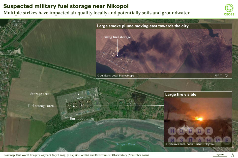
3.2.4 Nikopol fuel and military depot [WISEN L2 ID: I1118]
WISEN records two incidents in March 2022 at an oil storage site west of Nikopol. The largest, on 29 March, sent a dark smoke plume almost 20 km towards the city, and satellite imagery later showed several burnt-out storage tanks. Large fuel fires cause substantial air pollution, while damaged storage can contaminate soils and groundwater; an example of a single strike creating multiple harm pathways.
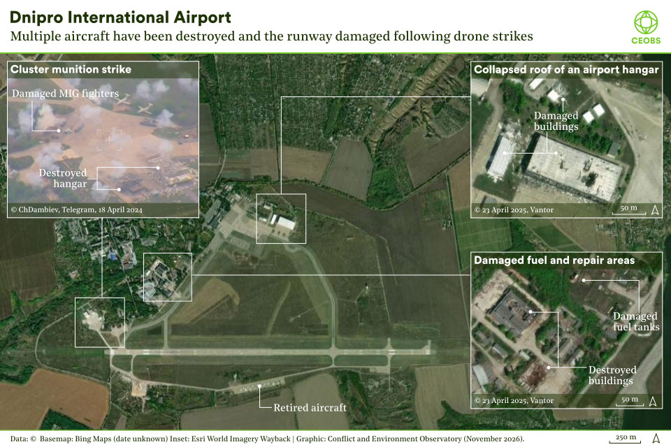
3.2.5 Dnipro International Airport [I923]
WISEN records eight Level 2 incidents at the airport, affecting aircraft, shelters, terminal buildings, fuel storage, warehouses and workshops. Missile strikes, some using cluster munitions, caused large fires and widespread damage, and one hit the airport’s emergency and rescue unit, potentially weakening its response to later attacks. Although no strike has been recorded since April 2024, the site is left with a complex mix of fuel contamination, debris and explosive residues.
4. What does WISEN-Ukraine tell us about the environmental consequences of the war?
4.1 Four characteristics of environmental harm in the full-scale invasion
Taken together, the data show environmental harm that is widespread, locally severe, diverse and frequently cumulative. Incidents have occurred across the country, but are concentrated along the front lines and in areas that have experienced occupation or repeated attacks. Some caused immediate, highly visible damage; others created risks that may persist for years.
The destruction of the Kakhovka dam became emblematic of the war’s environmental toll, but WISEN records incidents affecting 21 dams, alongside thousands of other sites. These impacts interact: repeated attacks layer new contamination onto earlier damage, and wartime pollution adds to a substantial industrial legacy, much of it inherited from the Soviet era. Much of the harm stems from damage to objects indispensable to the civilian population and to local economies.
4.2 What WISEN shows, and what it cannot show
WISEN-Ukraine is a structured record of documented incidents and their associated risk and harm; it does not measure the war’s total environmental cost. Reporting has varied by region and over time; restrictions on publishing information from government-controlled areas, introduced for understandable security reasons, have reduced the visibility of some incidents. Forest loss, cratering, habitat disturbance and many impacts on wildlife are poorly captured by an incident-based approach, and almost all Level 2 assessments concern direct rather than indirect harm.
Some consequences, such as groundwater pollution, chronic exposure and long-term ecosystem effects, may only become clear through field sampling and monitoring. WISEN-Ukraine is strongest when used as a prioritisation tool, identifying patterns, risks and priorities for further investigation.
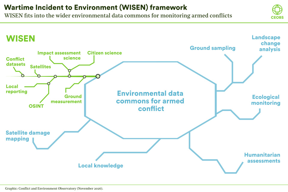
5. WISEN within Ukraine’s environmental data commons
Much of the work of documenting the war’s environmental toll has been led by Ukrainians — government agencies, scientists, civil society organisations, journalists and local communities — frequently in extraordinarily difficult conditions. International researchers, satellite assessments and OSINT investigations have added to a growing landscape of monitoring.
WISEN-Ukraine is one contribution to this shared effort, and to a wider international movement to make the environmental dimensions of armed conflict more visible. Its value lies not in replacing other sources, but in offering an independent, standardised record that can be compared across places, sectors and time, and combined with pollution monitoring, land cover change, protected area assessments, health data or field investigations to reveal patterns that no single dataset can reveal in isolation.
5.1 What can the data be used for?
WISEN-Ukraine is openly available, first and foremost to those working in Ukraine. It can help identify locations and sectors needing deeper investigation, prioritise assessment and remediation, support recovery planning and enable cross-dataset research.
Since the start of the full-scale invasion, the WISEN framework has underpinned our work on Ukraine and allowed us to advocate more effectively for the environment in war. These are some of the ways that we have used data and insights from the WISEN-Ukraine dataset:
- Developing thematic briefings on the environmental consequences of the war for the UN Environment Programme.*
- Preparing a wide range of publications for the Organization for Security and Cooperation in Europe, and briefing its delegations on the environmental situation.*
- Contributing to the process to develop the Ukraine’s High-Level Working Group on the Environmental Consequences of the War’s Environmental Compact for Ukraine.*
- An EU4Environment project to map conflict damage to Ukraine’s Emerald Network sites and to develop methodological guidelines for remote assessments.
- Working with Ukraine on the drafting and successful passage of a UN Environment Assembly resolution on monitoring environmental harm in areas affected by armed conflicts.
- Extensive work with media organisations reporting on the environmental dimensions of the conflict.
- The provision of technical advice to legal experts working on accountability.
* In collaboration with Zoï Environment Network.
Looking ahead, we will be using WISEN-Ukraine data for a Wellcome Trust funded project on conflict pollution, soil health and the law, and supporting researchers investigating air quality during conflicts. We are actively seeking other applications for the data that contribute to the protection of people and the environment.
5.2 From documenting harm to recovery and accountability
For recovery, WISEN-Ukraine provides a baseline for identifying pollution hotspots and prioritising clean-up. For justice, systematic documentation can support damage assessments, reparations and investigations into serious environmental harm. And for advocacy, it adds weight to what Ukrainian environmental organisations have argued since 2022: that the war’s environmental consequences are inseparable from its human toll, that the environment must be part of recovery, and that Russia must be held accountable for the damage its war has wrought.
The harm is far from over. Rather than easing, the war’s environmental toll is deepening, with renewed attacks on energy infrastructure since summer 2025 and some of the highest levels of assessed risk recorded in late 2025 and early 2026. As winter 2026 approaches, Ukrainian energy infrastructure is once again the object of Russian attacks. Every new incident adds to the burden Ukrainian communities, institutions and ecosystems will carry for decades.
We wish to continue to document new incidents and track how existing damage evolves, and wish to invite support to do so. But documentation is only a starting point. Ukraine needs sustained international solidarity and support, and that support must include the environment: for monitoring and field investigation, for remediation, for the people and institutions doing this work on the ground, and for accountability for the harm caused. A just and sustainable recovery depends on it.
5.3 How can I access the data?
The Level 0 and Level 1 data, including facility-level summaries of Level 2 harm scores, are freely available on Zenodo under a CC BY-NC 4.0 licence. Detailed Level 2 documentation is available on application, subject to a data access agreement. Before using the data, please read the methodology and codebook, which explains how the data were compiled and their limitations.
Acknowledgements
WISEN-Ukraine has been a collaborative effort involving people, donors and partners.
CEOBS staff
We are grateful for the time, hard work and patience shown by the CEOBS staff who’ve worked tirelessly to curate WISEN-Ukraine. This includes present members of staff: Eoghan Darbyshire, Linas Svolkinas, Anna McKean, Leon Moreland, Jonathan Walsh; and past members: Rebekah Harries, Iryna Babanina, Rob Watson, Jay Lindle, Randa Kachef and Natalie Meiklejohn.
We have also been aided by a team of student researchers: Alex Shaw, Niamh de Búrca, Olivia Putnam, Kitty Taylor, Billy Bingham-Hall, Fiona Clark, Prathiga Srikanthan and Boyan Shahpasov.
And supported by volunteers and interns: Philipp Barthelme, Miguel Madrid, James Winter, Zach Torres, Daniel Dean, Lydia Miller and Lilla Albert.
Donors
Work on WISEN-Ukraine has been possible thanks to the financial support of the Norwegian Ministry of Foreign Affairs, UNEP, OSCE and the UNDP. The Joseph Rowntree Charitable Trust has also supported work on this project.
Partners
Collaboration with partners has been key, including Zoï Environment Network, whose Ecodozor data has formed part of the analysis; Mnemonic’s Ukrainian Archive, which has allowed us to archive social and traditional media posts, and the Decentralized Damage Mapping Group, whose radar data has supported our L0 analyses.
This report was written by Iryna Babanina, Eoghan Darbyshire, Jonathan Walsh, Linas Svolkinas and Leon Moreland. Found this useful? Please donate so that we keep monitoring harm.
- These patterns need cautious interpretation. WISEN records what could be identified, verified and assessed, not every incident that occurred. Reporting intensity, satellite visibility, access to occupied areas and the availability of evidence have all varied through the war. Detailed Level 2 assessment is also uneven between sectors: for example, a much larger proportion of verified chemical incidents have been examined in depth than energy or military incidents. Apparent differences in frequency or severity therefore cannot automatically be interpreted as changes in targeting or environmental impact.
- Special cases were introduced for facilities repeatedly affected by incidents that did not always individually meet Level 1 thresholds, generated unusually large volumes of reporting, or changed hands multiple times, particularly along the frontline.