New guidance for documenting war’s impact on protected areas
Published: February, 2026 · Categories: Publications, Ukraine

CEOBS has recently supported the Ukrainian government in developing guidance for documenting how war and occupation have impacted its nature reserves. In this post Iryna Babanina introduces the project and our work.
Introduction
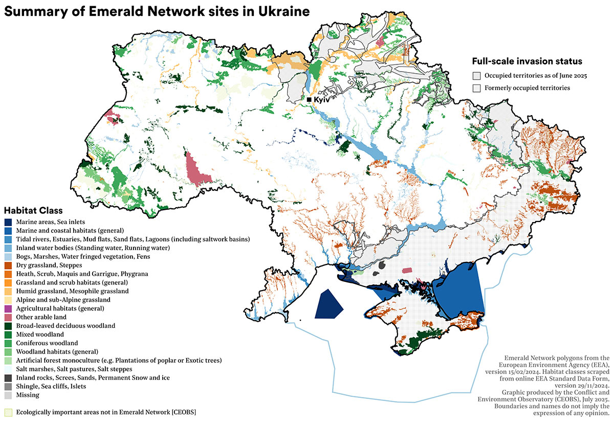
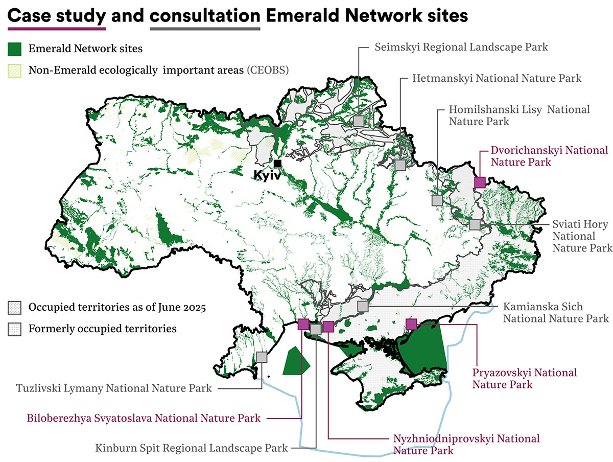
Russia’s war against Ukraine continues to cause widespread and severe damage to its landscapes and habitats. This includes many of its most important nature reserves and protected areas. Many of these sites are part of the Emerald Network, a regional network of areas of special conservation interest created to ensure the long-term survival of biodiversity and habitat types. The Network was established in 1989 by the Council of Europe to implement the Convention on the Conservation of European Wildlife and Natural Habitats (hereinafter referred to as the Bern Convention). Ukraine was in the process of finalising its legal regime to manage its Emerald Networks sites when the full-scale invasion began, and work to do so is ongoing, with 537 proposed and adopted sites partially overlapping with its national protected areas.
While the Emerald Network had established guidance for studying anthropogenic pressures on sites, as a peacetime conservation instrument it did not have standards for assessing the risks or impact of armed conflicts; nor does the Bern Convention contain provisions regarding its application in situations of armed conflict and occupation. And so, within the framework of a wider EU4Environment project ‘Recommendations on the Methodology for Assessing Anthropogenic and Military Impact on the Emerald Network Sites, Preparing Site Restoration Strategies, and Ensuring Effective Management’, CEOBS developed a methodology and recommendations for assessing wartime damage.
Understanding harm
Our work on the project required a number of different methods, including:
-
A standard data form analysis to derive information on Emerald areas and habitats near the front line or under occupation;
-
Country-level geospatial analysis;
-
OSINT and remote sensing;
-
Consultations with the specialists of national park administrations;
-
Desk studies and legislation analysis.
Analysis by Zoï Environment Network had found that by early 2025, and of Ukraine’s 538 approved and proposed Emerald sites, 47% were either occupied or had been within 10 km of the front line. This amounted to 250 sites with a total area of 71,957 km2. When we began the study in November 2024, 129 sites with a total area of 47,566 km2 remained occupied. Given that Russia has occupied ~20% of Ukraine’s territory, the figures indicate that the war is having a disproportionate impact on its Emerald sites.
Further research is recommended to determine the extent to which the war has also disproportionately affected rare and endemic species which, unlike more generalist species, can be much more severely affected by population loss and habitat destruction.
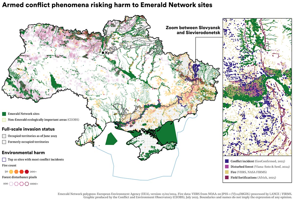
Building on this work, we analysed data on landscape fires and forest cover disturbance, detecting considerable increases in both as a result of the conflict.1 Between the start of the full-scale invasion and December 2024, 35,778 fires were recorded in those Emerald sites that were occupied or within 10 km of the front line, compared with 6,098 fires in all other areas. Of these affected sites, fire activity was classified as anomalous in 69% of cases (172 sites).2 Similarly, a large difference was observed when comparing forest cover disturbances in 2022 and 2023. In the occupied areas or areas within 10 km of the front line, 43,262 ha of forest cover were disturbed, compared to 29,490 ha in non-occupied areas.
Digging deeper
Conflict-related incidents, land warfare and fortifications were also explored as risk factors for Emerald Network sites using satellite and OSINT tools. However, the available datasets comprise only reported or visible cases and thus represent only a fraction of the full picture.3 To develop a more comprehensive understanding, we conducted written interviews and a consultation event with protected area staff and experts. We also developed in-depth case studies on a selection of sites. The interview questionnaires included 27 questions covering direct harm, indirect harm and pre-war anthropogenic pressures that may have been compounded or otherwise influenced by the war.
All administrations of national nature parks (NNP) and regional landscape parks (RLP) identified the following types of military factors as directly and physically affecting Emerald sites:
-
Artillery and missile shelling;
-
Air and drone strikes;
-
Combat operations involving heavy military equipment;
-
Construction of fortifications;
-
Military waste.
Respondents unanimously identified the use of explosive weapons and contamination with explosive remnants of war (ERW) as a serious problem.4 Moreover, explosive ordnance exacerbated the fire threat to ecosystems, as firefighting became complicated and dangerous in contaminated areas.5 All national parks located close to the front line identified mine action — including non-technical surveys and mine clearance — among key priorities. Valuable information was obtained on damage and remediation needs, on staff needs, and on the losses to park equipment and data caused by direct attacks or looting by the occupying forces.
Specific harms reported from particular protected areas
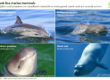
The administration of the Tuzly Lagoons (Tuzlivski Lymany) NNP reported the consequences of naval operations and factors such as ship movements, sonar use, and pollution, which affected dolphin populations in the Black Sea. The park staff recorded dozens of cases where cetacean carcasses were washed ashore within the park. Most of these deaths were thought to be linked to naval battles for Zmiinyi (Snake) Island in 2022.
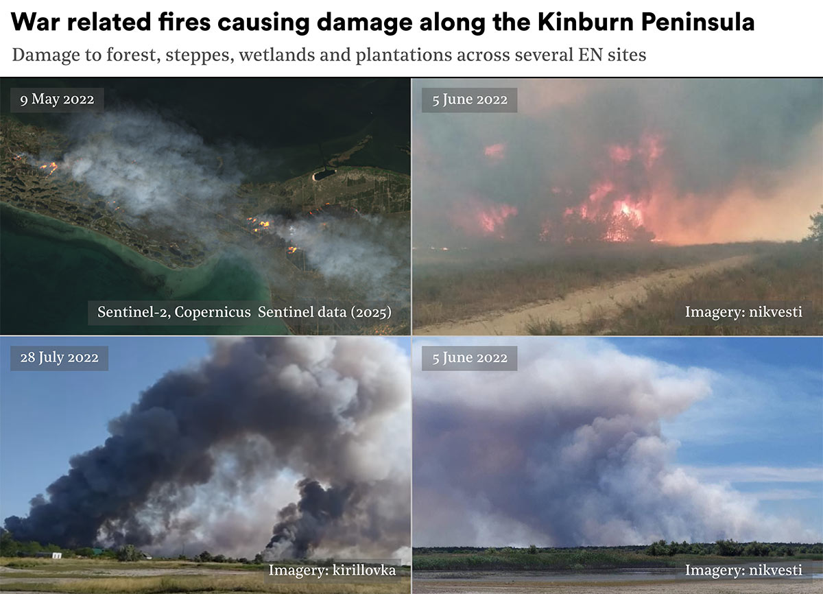
The valuable ecosystems of the Biloberezhzhia Sviatoslava NNP, whose territory remains occupied and used for the permanent deployment of Russian troops, had suffered the greatest destructive impact from the construction of fortifications and artillery shelling. A unique orchid meadow on the territory of the Kinburn Spit was also under threat of destruction.
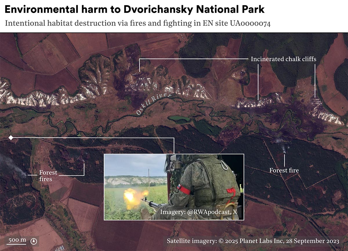
Dvorichanskyi NNP reported significant noise pollution and disturbance, in particular from the operation of Russian air defense systems and flights of Russian aircraft and drones over the territory: 10-15 helicopter overflights per day at an altitude of 50-70 metres. The park specialists also provided a detailed list of impacted species based on pre-war mapping.
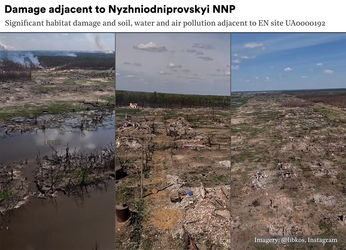
For the Lower Dnipro (Nyzhniodniprovskyi) NNP, the most significant event was the destruction of the Kakhovka Dam and the flooding of nearly all the park’s territory, which caused pollution by industrial chemicals, household waste, and displaced bottom sediments. The park staff also mapped extensive ecosystem fires.
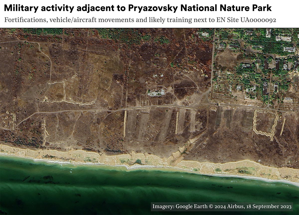
The project included four case studies based on OSINT and remote sensing, which helped to gather data on damage to temporarily inaccessible locations. These included: Dvorichansky National Park, Nyzhniodniprovskyi (Lower Dnipro) National Park, the Kinburn Spit Peninsula and Pryazovskyi National Park. The observations detected large-scale forest fires on the Kinburn Spit; damage to rare geological formations and associated unique ecosystems such as chalk cliffs in Dvorichanskyi NNP; and geomorphological damage sometimes resulting in extensive cratering and the formation of a “military landscape” in Nyzhniodniprovskyi NNP.
Law, governance and indirect harms
In addition to direct harm, the war has brought with it a number of legal and structural threats to Emerald Network sites. Military and security activities involve the construction of fortifications and allocation of land plots within protected areas for the defensive purposes. These works disturb land cover, disrupt ecosystem connectivity and require increased use of timber and other natural resources. A typical border strip will be located 30-50 metres from the state border, or the bank of a border river, along borders with the EU countries, and up to 2 km along borders with Russia and Belarus. The construction of fortifications affects a number of national parks and Emerald areas, among them some of the most important ecosystems of the Ukrainian Polissya, probably one of the least anthropogenically transformed areas of Europe and a habitat for many rare species.
Meanwhile, post-war recovery activities such as agricultural recovery, mining and other resource extraction, are likely to affect a number of Emerald sites that have not yet been formally designated as protected areas; Ukraine has yet to fully adopt its national Emerald Network law. A significant portion of local community budgets depend on land tax and land lease income, and affected communities facing financial difficulties and recovery costs may be forced to allow the conversion of previously unused lands in a natural state to new economic uses.
Outcomes
Despite the many direct and indirect pathways through which armed conflicts can impact protected areas, the pre-existing anthropogenic threat classification system for Emerald sites only addressed the consequences of military exercises. We used the study findings to propose a new classification system for war-related damage factors and for their relationship with the types of direct and indirect damage they cause. Because of the access constraints common to conflicts, we explored the potential of applying remote sensing methods to assess the impact of conflict factors and to detect damage, finding that it can help in remote evaluations, particularly when combined with local expertise and observations from the ground.
A key outcome of the project has been phased guidance that can be used by the Ukrainian authorities in damage assessment to sites. The conflict threat classification system developed for the project has also been shared with the Bern Convention Secretariat and it is our hope that it will be incorporated into their existing system. We presented our summary results at EU4Environment webinars for Ukrainian and regional experts on October 3rd and November 10th 2025.
Iryna Babanina is a Researcher at CEOBS; our Emerald Network project team also included Eoghan Darbyshire, Anna McKean, Linas Svolkinas and Doug Weir. Our thanks to Olesya Petrovitch, Stefanos Kouroupis, Nickolai Denisov and to all the Ukrainian park staff who contributed their expertise to the project. If you find our work useful, please consider making a donation so that we can continue it.
- Based on the VIIRS Active Fire and Thermal Anomalies product processed by LANCE/FIRMS.
- Fire activity is considered anomalous if the annual number of fires exceeds twice the average number of fires in those years that didn’t experience armed conflict.
- Open-source conflict data research identified 940 incidents in occupied Emerald sites or those within 10 km of the frontline, compared with only 10 incidents outside these areas. These incidents are primarily related to military activity, such as land combat, drone use, and long-range weapons. Satellite image analysis revealed Russian or Belarusian military earthworks (fortifications, trenches, bunkers, etc.) at 33 locations. Another dataset tracking military positions indicates that Russian forces are positioned in 45 Emerald sites, and Ukrainian forces are positioned in 40 Emerald sites. It is likely that there are many other cases in adjacent areas directly surrounding Emerald sites.
- For example, 11,895 ha of the Sviati Hory NNP and 11,673 ha of the Hetmanskyi NNP were considered dangerous and required survey. The Biloberezhzhia Sviatoslava NNP reported that about 15,000 ha of the Dnipro-Buh estuary are contaminated with explosive ordnance. Even in the Tuzly Lagoons NNP — the only coastal park not located directly on the frontline — about 5,000 ha out of 27,865 ha are considered potentially hazardous. Cases of sea mines washed ashore have been reported, as well as explosive devices displaced by floodwaters from the Kakhovka Reservoir following the dam’s destruction.
- At present, mine clearance operations are progressing slowly due to limited resources and difficult terrain.Thus, in different departments of Sviati Hory NNP, from November 2022 to January 2025, just 0.3% of forest areas and a minor share of firebreaks and roads were cleared due to high contamination, difficult terrain, and heavy soils. This park also reported incidents of vehicle damage and staff injuries caused by mine explosions. In other areas close to the frontline, such as Dvorichanskyi Regional Landscape park, mine clearance has not started yet while active fighting continues. The Dnipro River delta within the Lower Dnipro NNP is also contaminated with EO, and underwater clearance is particularly complex and risky.