After another severe fire season in Europe, new research explores whether military training areas have their own distinctive fire regime.
Is there a pattern to fires on military sites across Europe? And is it changing in response to the climate crisis and increasing military spending? Students Sara Niknam, Adam Krid and Ritchie Davelaar from Utrecht University’s Open-Source Global Justice Investigations Lab consider the evidence.
Context
As European countries raise military spending and step up training, one environmental risk is becoming harder to ignore: fire. Live ammunition, explosives and pyrotechnics are all potential ignition sources, and fires on training grounds can damage habitats, generate air pollution and spread beyond the boundaries of military properties.
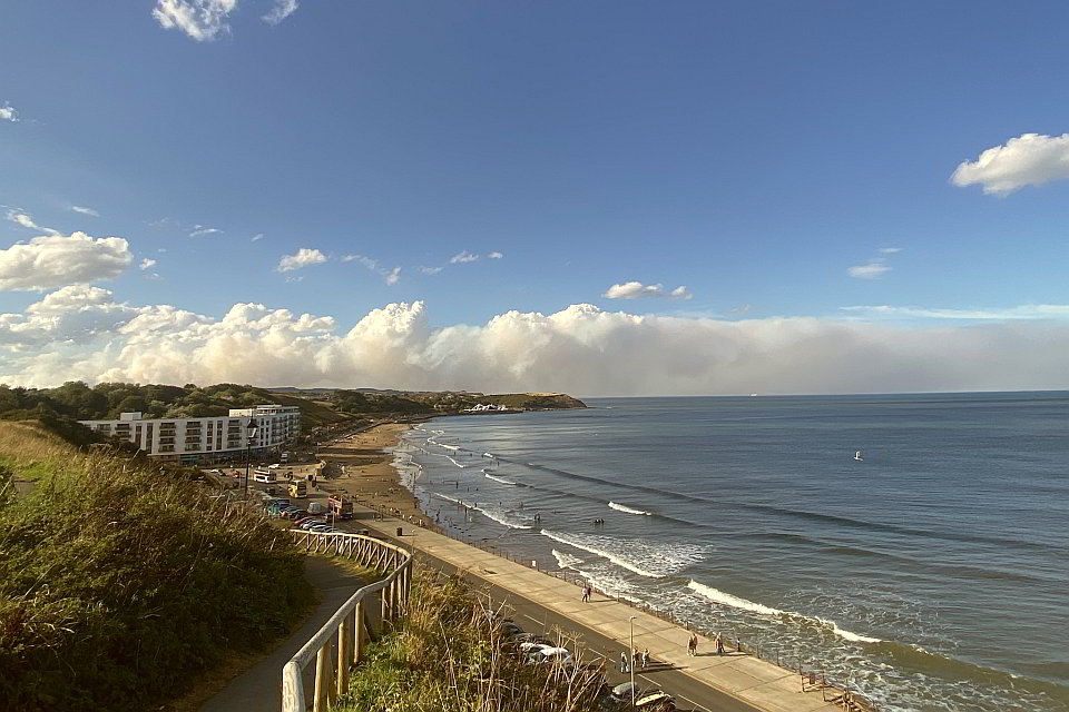
A 2025 BBC investigation using Freedom of Information (FoI) requests identified 1,178 fires linked to UK Ministry of Defence sites since 2020; 101 of these occurred in the first half of 2025 alone, and were attributed to training or manoeuvres. That investigation helped prompt this research — which excluded the UK — to explore whether there was a similar pattern across continental Europe. Our student research team combined satellite fire detections, burned-area observations, fire-weather data and case studies to examine NATO military areas between 2019 and 2025; here’s what we found.
Finding #1: Military activities can ignite fires
The Netherlands offers several documented cases of military training starting fires. For instance, a fire at Leusderheide in April 2021 was caused by a smoke grenade used during an exercise. In April 2025, a fire broke out at Harskamp during an exercise involving pyrotechnics such as smoke pots, which are normally intended for use only on less flammable sandy ground. In that case, the fire was ignited after a dry February and March had already left vegetation unusually susceptible to burning. A further fire at ‘t Harde the same month also coincided with a military exercise, though its cause is unclear.1
The level of attribution for Leusderheide and Harskamp is unusual. Details of exercises, munitions and individual incidents are often unavailable, and typically only emerge through media reporting, parliamentary questions or FoI requests. That made Grafenwöhr Training Area in Germany a useful case study: it is one of only a few military sites in Europe that publishes firing schedules, including broad categories of permitted ammunition.
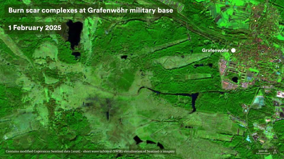
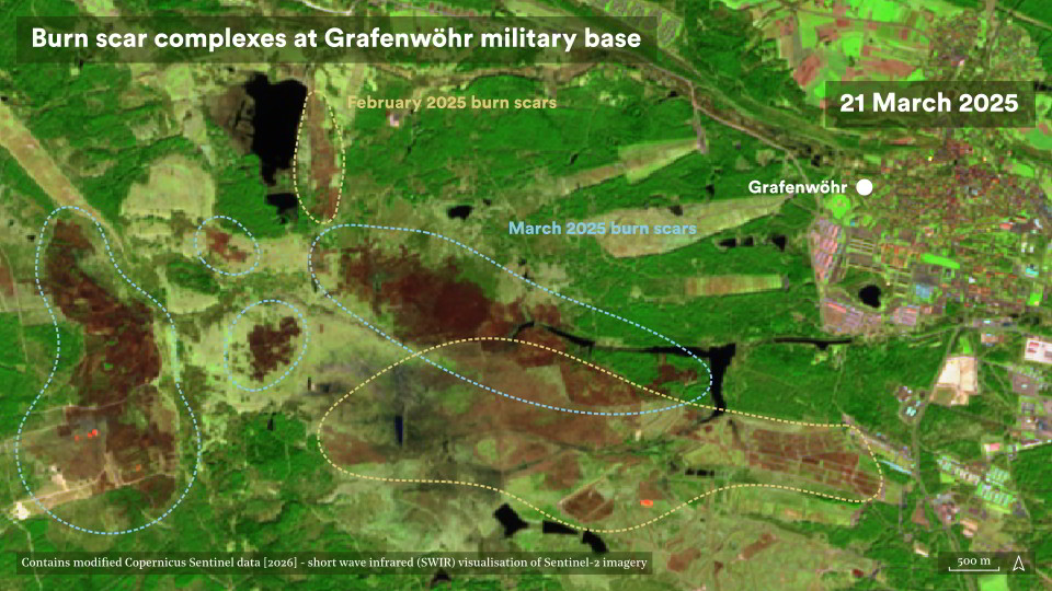
When we cross-referenced NASA FIRMS satellite fire detections with before and after satellite imagery, and Grafenwöhr’s published schedule, we found that fires repeatedly coincided with periods when firing was permitted. This included months during which weather conditions were relatively unfavourable for ignition.
Although the published schedules were too broad to link particular rounds to particular fires, Grafenwöhr also raised questions about ammunition types. Research has shown that rifle ammunition can ignite vegetation, with ignition likelihood varying according to bullet construction and composition. This suggests that ammunition type, rather than calibre alone, deserves closer scrutiny.
Finding #2: Military land appears to have a distinctive fire regime
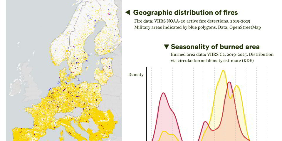
Military training areas covering 0.46% of Europe’s land area were mapped using OpenStreetMap. These were cross-referenced against the more than 1.1 million VIIRS active-fire detections that were recorded across the study countries between April 2018 and December 2025. Fires were grouped into spatio-temporal clusters, with a cluster classed as military-associated where its earliest detection fell inside a mapped military area.
This method identified 3,519 military-associated fire detections and 331 associated burn scars: around 0.3% of all active-fire detections and 0.6% of burned-area detections across the study region. This is probably an undercount as firebrands — embers with the capability of setting additional fires — can be transported many kilometers from the main fire.
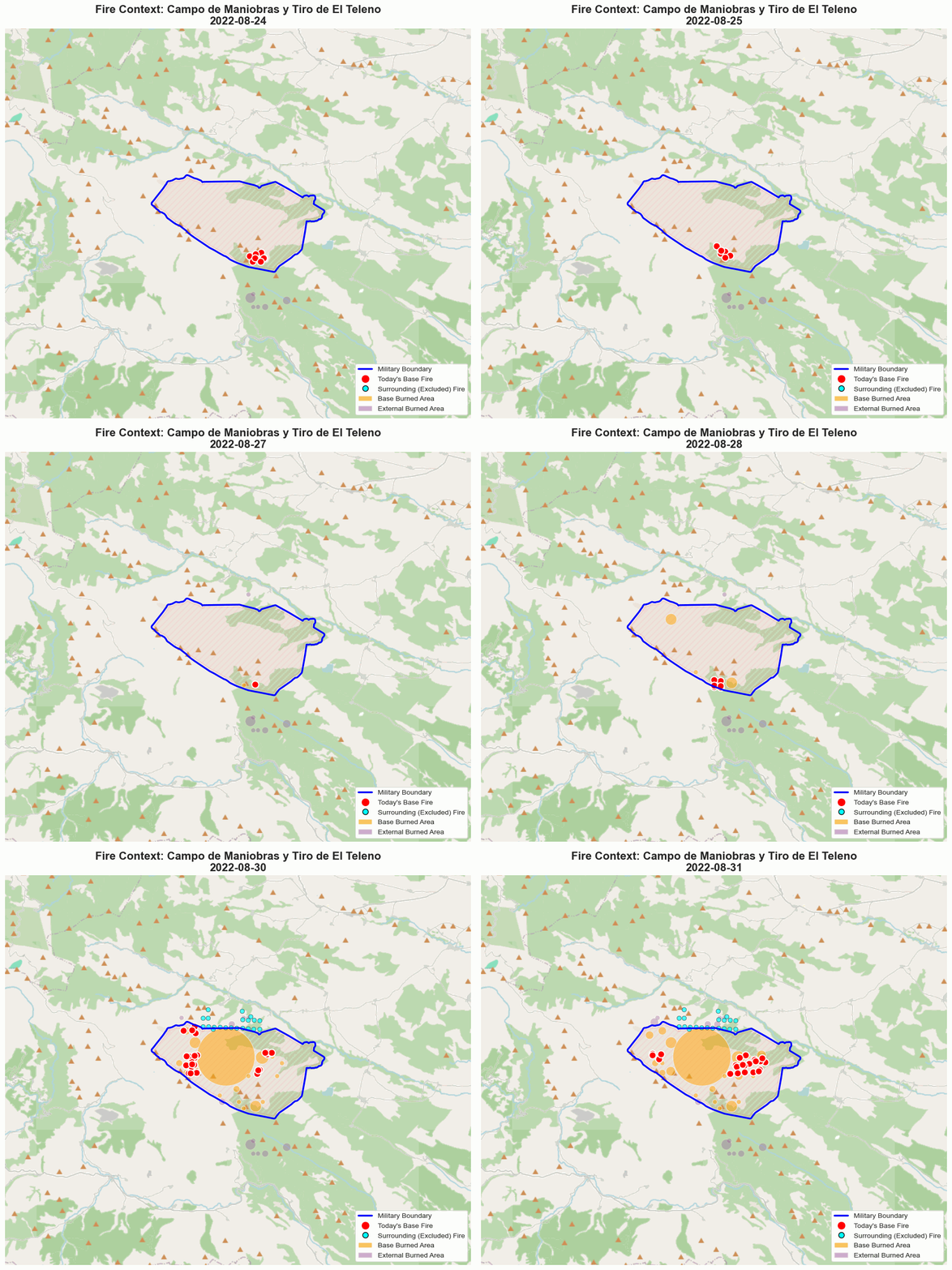
These totals for continental Europe conceal stark differences between countries. We found that the burned area per unit of military land exceeded that of non-military land in Germany, France, Spain, Hungary, Romania and North Macedonia; whereas elsewhere, military land burned far less than the surrounding landscape, including in Albania, Greece, Italy, Montenegro and Portugal. Hence the picture is therefore not one of military land burning unusually everywhere, instead we detected an uneven, geographically patchy footprint.
A different fire season
As we expected based on landscape fire risk, the frequency of both military and non-military fires builds steadily from May to a broad late-summer peak. Military-associated fires, however, were relatively more prominent outside the summer landscape fire season, including during late winter and early spring. This is a striking difference, and is consistent with military training providing an additional source of ignition outside the conventional landscape fire season.
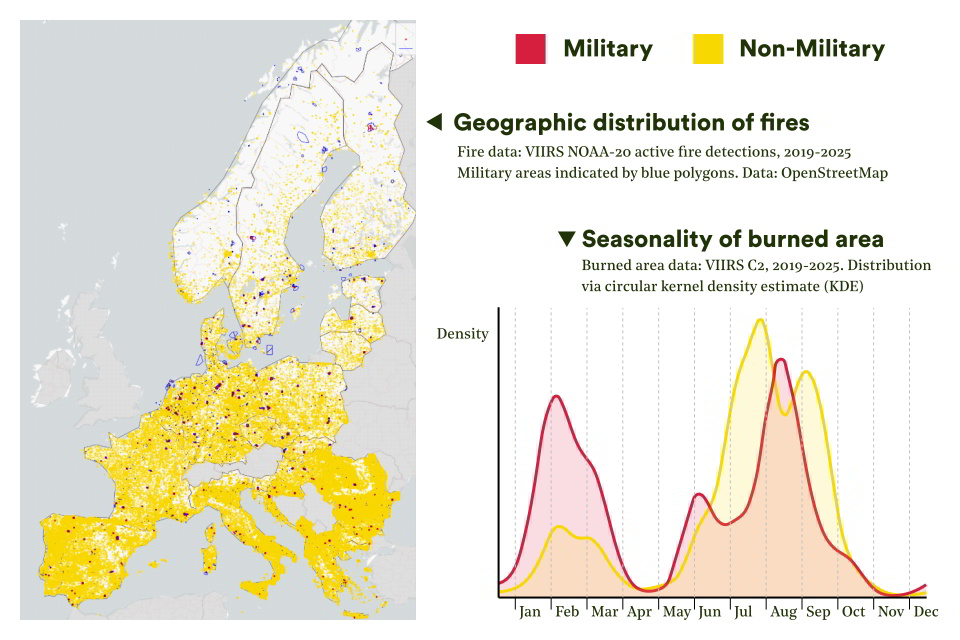
It is likely that this late winter/early spring fire activity matters ecologically. Spring overlaps with the breeding and growing season for many species; fires do not need to become large landscape fires to cause harm. This study didn’t measure ecological impacts directly but the pattern suggests that looking only at the number of hectares burned will understate the full picture of harm from military-origin fires.
We also found that at some times of the year relatively high numbers of detections mapped onto a relatively small newly detected total burned area. This is consistent with non-landscape fires, small, rapidly controlled fires, or repeated burning of already-disturbed ground, although the satellite record cannot distinguish between these.
Fires occur outside the most severe fire weather
When we matched detections against the Copernicus Fire Weather Index (FWI), we found that the average conditions for military and non-military fires were broadly similar, but their distributions were not. No military-associated fire was recorded above a FWI of 70, Copernicus’s very extreme threshold. This may suggest some restraint during periods of exceptional danger, although testing this properly would require data on training schedules set against local fire-danger conditions. Fires did still occur at FWI values of 50–70, which are already classed as extreme.
Our study found that spatial pattern, seasonality and fire weather all point to a distinctive military fire regime. However, as only 7.5 years of satellite data are available, it is difficult to say from this study alone if climate change is exacerbating military fires, as this period is not long enough to account for climate variability. Further research is needed.
Open question #1: Does more military activity mean more fire?
If training generates ignition opportunities, more intensive years should show more fires. The record contains one clear anomaly: military-associated fire detections and burned areas both rose sharply in 2022, a year that combined the lifting of COVID-19 restrictions with a sharp increase in NATO training following Russia’s full-scale invasion of Ukraine. The non-military fire record shows no comparable rise.
Military training regimes can be highly variable and unfortunately there is no consistent Europe-wide dataset on military training and its intensity against which to test that link directly. Grafenwöhr is very much the exception. Meanwhile, other factors, including weather, cannot be ruled out. For now, the data for 2022 provides a lead worth following rather than proof of cause and effect.
Open question #2: Is European rearmament already increasing the problem?
Across the seven complete years of data (2019–25), neither military-associated fire detections nor burned areas show a clear upward trend, and comparing national military spending against fire activity produced no consistent relationship.
However, budgets are a very blunt proxy for activity on the ground. New spending can go on equipment, infrastructure or personnel without translating into more training days or ammunition use, and seven years is a short window against the natural variability of fire weather. The underlying data has its own limits too; the OpenStreetMap military-land layer is only as complete as its contributors allow, VIIRS will miss smaller or obscured fires, and the clustering method cannot fully reconstruct fire spread beyond the boundaries of military land. Attribution remains hardest precisely where transparency is weakest.
While the evidence does not show that European rearmament has already produced a sustained rise in military-linked fires, it does show that military land carries an identifiable fire signature that can now be tracked as training intensity and climate risk both change.
Conclusions
Taken together, the findings suggest that military activity can and does ignite fires, and that military land shows a distinctive spatial, seasonal and meteorological fire pattern. Whether Europe’s rearmament is intensifying that pattern is not yet answerable from this dataset. The seven-year satellite record is too short to separate long-term change from natural variability, whilst irregular training cycles, incomplete military-land mapping and limitations in detecting and tracking smaller fires all complicate attribution.
This study shows that there are technological opportunities to further investigate the relationship between landscape fire and militaries. Future work should combine longer and multiple satellite and climatological datasets with improved fire-clustering, manual verification and better access to military training and incident data, while also investigating the ecological and emissions impacts of repeated burning.
This blog is an abridged version of a report by Sara Niknam, Adam Krid and Ritchie Davelaar under the supervision of Thijs Jeursen and CEOBS. They are a team of students from Utrecht University’s Open-Source Global Justice Investigations Lab. The students were supported by Eoghan Darbyshire and Leon Moreland at CEOBS. If you find our work useful, please consider making a donation so that we can continue it.
CEOBS’ perspective: where should military-fire research go next?
This work suggests that military training areas can have distinct fire regimes. But how well is this understood by militaries, civilian authorities and the public? How should these impacts factor into the social licence militaries have to operate? Are they an unavoidable cost of maintaining security, or should military management and behaviour change?
CEOBS considers that there is not yet enough evidence to answer these questions, and further research is needed in three areas:
1. What are the full environmental impacts of military fires?
Burned area captures only part of the harm. What are the exposures to air pollution; especially given it is not just vegetation burning but can also be contaminated soils? And what of impacts on air pollution, habitats, soils, post-fire water quality and greenhouse gas emissions? How important is repeated burning, and are fire-related emissions adequately reflected in military emissions accounting? How do military fire regimes outside Europe compare, including those affecting overseas training ranges?
2. How effectively are militaries managing fire risk?
Militaries have responsibilities for prevention, preparedness and response, but to what extent are these being met? How does UXO affect firefighter access and fire suppression? How should firebreaks and vegetation management be balanced against ecological protection? If training activity increases, is investment in prevention and firefighting capacity keeping pace? And should militaries provide greater transparency on fires, their causes and mitigation? What roles are there for civilian oversight bodies?
3. How significant is landscape fire as a security risk?
Fires are not only an environmental consequence of military activity; they can also threaten military infrastructure and operations. How vulnerable are bases, ranges and other critical sites to wildfire? In Europe during the summers of 2025 and 2026 we saw how UXO amplifies emergency risks; what does this look like under future climate scenarios? And how seriously should deliberate ignition, including as a means of disruption or hybrid warfare, feature in military resilience planning?
- This contrasts with a recent fire at the same location after this study period: on 29 April 2026 a large fire was ignited during a planned explosives exercise. The subsequent investigation concluded that the most likely cause was glowing-hot material, including fibreglass fragments from older mines and residues from flares used in the exercise, being thrown from the blast pit.